|
0 members (),
57
guests, and
13
robots. |
|
Key:
Admin,
Global Mod,
Mod
|
|
 Advice re: North Slope of Mt. Whitney
|
Joined: Feb 2012
Posts: 1
|
OP

Joined: Feb 2012
Posts: 1 |
Hello all,
Looking for a bit of advice. I'm planning a trip for this summer ending with a jaunt up Mt. Whitney (August 2 or 3). For background: I've taken the trail up Whitney before. I'm an experienced hiker (comfortable off-trail, etc.) and used to do some rock climbing in Yosemite and SEKI. Haven't done any "real" climbing for years but still enjoy cross country, scrambling, etc.
I'm taking a look at going up the North Slope of Whitney from Arctic Lake. I haven't been able to find much info about the North Slope route(s) aside from Secor. He says "Class 2-3. Climb the left side of the north slope, just under the northeast ridge. Ascend some shallow chutes leading to a 50-foot high wall of broken blocks. Pass through these blocks and climb directly to the summit."
Anyone been up this way? I'd greatly appreciate any tips.
|
|
|
Re: Advice re: North Slope of Mt. Whitney
|
Joined: Sep 2009
Posts: 8,509 Likes: 103
|
|
Joined: Sep 2009
Posts: 8,509 Likes: 103 |
The only person I know of who has done that is Rick Kent, an extraordinary climber, known for very long multi-peak day hikes. I believe he has climbed down from Mt Russell, and up the north slope of Mt Whitney at least once, maybe more. Searching for: "Rick Kent" whitney russell will turn up some hits. Here is a picture of his from his album: Mount Hale & Mount Young - 8/28/2005Caption: North slope/face of Mount Whitney (as seen from Mount Hale)  Click for the full-size image. Somewhere, he has posted a view of Whitney's north slope from Mt Russell, with a line showing his route to the summit of Mt Whitney.
|
|
|
Re: Advice re: North Slope of Mt. Whitney
|
Joined: Sep 2009
Posts: 8,509 Likes: 103
|
|
Joined: Sep 2009
Posts: 8,509 Likes: 103 |
Here's a picture of the Mt Whitney north slope taken by Bob R from Mt Russell, in the album: 2010-07-09 Mt. Russell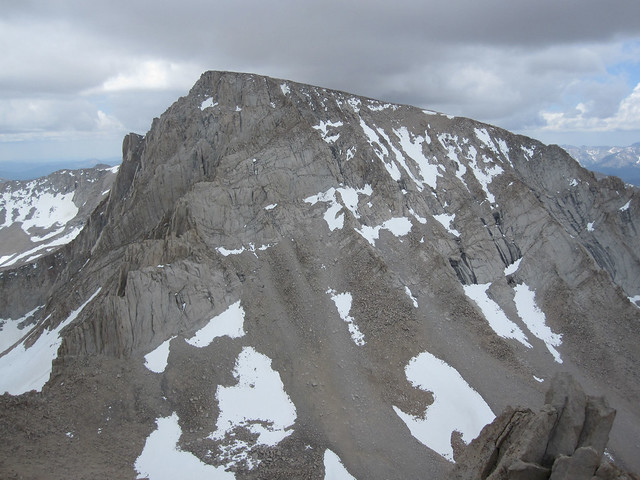 click for full size
|
|
|
Re: Advice re: North Slope of Mt. Whitney
|
Joined: Sep 2009
Posts: 8,509 Likes: 103
|
|
Joined: Sep 2009
Posts: 8,509 Likes: 103 |
Here's text from a report from Summit Post, posted Jan 30, 2003: "Mt. Russell, Mt. Muir, Mt. Whitney, and Mt. Carillon in a Day" (Link) We re-joined the trail, headed for Whitney, and made one detour to fill up on water from a melting snowfield before reaching the summit a little over an hour later. Amazingly, there were only 3 tourists on top, and as we arrived, they started down, leaving us to enjoy some solitude on one of the busiest peaks in the U.S., in the middle of the summer climbing season! We took in some calories and water, and descended toward the top of the Mountaineers Route. When we arrived at the notch that denotes the right turn to continue the Mountaineers, we kept on straight down the north slope.
The north slope descent was much more difficult than expected, steep and loose, with intermittent cliff bands and polished slabs. Patient route finding kept the difficulty in the 3rd-4th class range. There were many relicts of past rappels left on the slope, we found a servicable #2 Camalot, and an old ring piton, along with many rotten slings. The descent to the base and the subsequent crossing of the basin to the base of the South Face of Mt. Russell consumed an additional hour and fifteen minutes. And here's a description from RockClimbing.com on climbing the north face of Mt Whitney: Mt. Whitney : North FaceA description by Rick Kent: Mount Whitney - The North Face 2007 Pictures from that trip are here: Mount Whitney (19x) - North Face - 4/28/2007It sure looks hairy! 
|
|
|
Re: Advice re: North Slope of Mt. Whitney
|
Joined: Sep 2009
Posts: 8,509 Likes: 103
|
|
Joined: Sep 2009
Posts: 8,509 Likes: 103 |
Ok, found Rick Kent's route picture: In the album titled: Carillon (3x), Russell (4x), Whitney (6x), Keeler (1x), Muir (3x) 6/18/2005 IMG_1683.JPG (click for full size)  Caption: The North Face of Mount Whitney (as seen from Mount Russell's south slope) The red line was my approximate path up the North Face. This route seemed optimal though it was still very strenuous. The red box is the region where the Whitney Notch is located.
|
|
|
Re: Advice re: North Slope of Mt. Whitney
|
Joined: Feb 2010
Posts: 649 Likes: 52
|
|
Joined: Feb 2010
Posts: 649 Likes: 52 |
I can't add much to what Steve has already posted, but I have done that route. I did a 10-hour Carillon-Russell-Muir-Whitney trip in September, 2002. I did Muir before Whitney, so I could descend the Mountaineers' Route instead of the trail.
It's been almost ten years, but I'm going to guess that my route up the north face wasn't too different from the red line in Kent's photo. There wasn't very much snow left, but the snow that remained was very icy, so I had to avoid it with light hiking boots. The icy snow and some less-than-perfect route finding meant that I had to do a few short sections of fourth class rock. I'm sure it can be third class with better route finding. Some of the rock is loose, so be careful, especially if you have partners below you.
|
|
|
Re: Advice re: North Slope of Mt. Whitney
|
Joined: Feb 2010
Posts: 649 Likes: 52
|
|
Joined: Feb 2010
Posts: 649 Likes: 52 |
Just because someone has done a ski descent doesn't make a route easy. I climbed the Black Ice Couloir on the Grand Teton when it was seventy-degree ice. My guide had previously descended that route on skis.
|
|
|
Re: Advice re: North Slope of Mt. Whitney
|
Joined: Jan 2010
Posts: 1,034
|
|
Joined: Jan 2010
Posts: 1,034 |
Just because someone has done a ski descent doesn't make a route easy. I climbed the Black Ice Couloir on the Grand Teton when it was seventy-degree ice. My guide had previously descended that route on skis. well, judge for yourself - this isn't a 70 degree kamikaze route. Skiing Whitney's North Face
|
|
|
Re: Advice re: North Slope of Mt. Whitney
|
Joined: Sep 2009
Posts: 8,509 Likes: 103
|
|
Joined: Sep 2009
Posts: 8,509 Likes: 103 |
That would be kamikaze if I tried it. 
|
|
|
Re: Advice re: North Slope of Mt. Whitney
|
Joined: Jan 2010
Posts: 1,034
|
|
Joined: Jan 2010
Posts: 1,034 |
That would be kamikaze if I tried it. there definitely are a few "pucker" sections on that downhill - personally I have issues with the narrow sections more than the steep stuff.
|
|
|
Re: Advice re: North Slope of Mt. Whitney
|
Joined: Sep 2009
Posts: 1,261
|
|
Joined: Sep 2009
Posts: 1,261 |
There are routes that I have done by ski that I would never have been able to climb, regardless of slope, as it was the contour of the exposed rock that differed so much than when the same area was covered by snow. Dana is an example of a hike changed by snow: a straight up walk to the summit when covered by snow -- a miserable dance with scree when done in the summer.
I agree, Fish, that the narrow areas are far more tedious than the wide open steep areas, as it limits the aility to negotiate grade by traverse. I took the time to become an expert side-slipper, so that while my more aggressive buddies could out-ski me, they could not out maneuver me when the track became narrow & technical.
The body betrays and the weather conspires, hopefully, not on the same day. 
|
|
|
Re: Advice re: North Slope of Mt. Whitney
|
Joined: Nov 2009
Posts: 7
|
|
Joined: Nov 2009
Posts: 7 |
Ok, found Rick Kent's route picture: In the album titled: Carillon (3x), Russell (4x), Whitney (6x), Keeler (1x), Muir (3x) 6/18/2005 IMG_1683.JPG (click for full size) Caption: The North Face of Mount Whitney (as seen from Mount Russell's south slope) The red line was my approximate path up the North Face. This route seemed optimal though it was still very strenuous. The red box is the region where the Whitney Notch is located. Is that Whitney-Russell Saddle on the left? I did something like that many years ago when I was young and immortal didn't know better. I had no ice axe and the MR chute was full of snow. So I crossed the saddle and headed up a chute, moving right to the next chute each time it got too steep (as described in the Climber's Guide at the time). I did this with a huge external frame pack (Kelty Sonora), almost crawling at times. It was worth it. I took the trail down.
|
|
|
|
|


