|
0 members (),
121
guests, and
8
robots. |
|
Key:
Admin,
Global Mod,
Mod
|
|
 Re: HST - High Sierra Trail
|
Joined: Nov 2009
Posts: 1,037 Likes: 6
|

Joined: Nov 2009
Posts: 1,037 Likes: 6 |
can you tell if he is moving any faster as he burns off those 12 lbs of food?
|
|
|
Re: HST - High Sierra Trail
|
Joined: Apr 2012
Posts: 579 Likes: 3
|
|
Joined: Apr 2012
Posts: 579 Likes: 3 |
Looks as though he has started back down. Hope he has pictures of his route. It looks very difficult on the TOPO.
|
|
|
Re: HST - High Sierra Trail
|
Joined: Feb 2011
Posts: 1,572
|
|
Joined: Feb 2011
Posts: 1,572 |
Looks like weather. Intellicast interactive map shows a series of systems right on top of him for the past hour. This time of day, that usually means t-storms. Note he's retreating first off the ridge, down the fall line, then over to his ascent route. Covered the first 400 feet of descent in no more than 20 minutes, maybe a lot less.
Wherever you go, there you are. SPOTMe!
|
|
|
 Re: HST - High Sierra Trail
|
Joined: Nov 2009
Posts: 161
|
|
Joined: Nov 2009
Posts: 161 |
Black Kaweah was his plan on the several e mails we exchanged.
|
|
|
Re: HST - High Sierra Trail
|
Joined: Feb 2012
Posts: 44
|
|
Joined: Feb 2012
Posts: 44 |
I have got to come clean: I am jealous.  Instead of being at my desk right now, I'd love to be where he's at....sounds amazing... 
|
|
|
Re: HST - High Sierra Trail
|
Joined: Nov 2009
Posts: 582
|
|
Joined: Nov 2009
Posts: 582 |
Welcome to amazing world of Sierra Video Games.
|
|
|
Re: HST - High Sierra Trail
|
Joined: Feb 2011
Posts: 1,572
|
|
Joined: Feb 2011
Posts: 1,572 |
Welcome to amazing world of Sierra Video Games. HeeHee: Top Ten List SimSierra World of Campcraft Grand Theft Marmot Alpinelands PermitWars Legend of Laura Portal PackMan Uncharted SuperMario Ultralight
Wherever you go, there you are. SPOTMe!
|
|
|
Re: HST - High Sierra Trail
|
Joined: Oct 2009
Posts: 2,251 Likes: 1
|
|
Joined: Oct 2009
Posts: 2,251 Likes: 1 |
Welcome to amazing world of Sierra Video Games. HeeHee: Top Ten List SimSierra World of Campcraft Grand Theft Marmot Alpinelands PermitWars Legend of Laura Portal PackMan Uncharted SuperMario Ultralight 
Verum audaces non gerunt indusia alba. - Ipsi dixit MCMLXXII
|
|
|
Re: HST - High Sierra Trail
|
Joined: Oct 2009
Posts: 2,251 Likes: 1
|
|
Joined: Oct 2009
Posts: 2,251 Likes: 1 |
Verum audaces non gerunt indusia alba. - Ipsi dixit MCMLXXII
|
|
|
Re: HST - High Sierra Trail
|
Joined: Oct 2009
Posts: 2,251 Likes: 1
|
|
Joined: Oct 2009
Posts: 2,251 Likes: 1 |
Once Steve got past Jester Lake(49), he really got a move on! 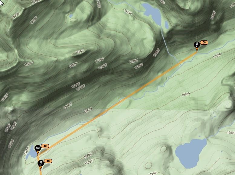
Verum audaces non gerunt indusia alba. - Ipsi dixit MCMLXXII
|
|
|
Re: HST - High Sierra Trail
|
Joined: Nov 2009
Posts: 582
|
|
Joined: Nov 2009
Posts: 582 |
Welcome to amazing world of Sierra Video Games. HeeHee: Top Ten List SimSierra World of Campcraft Grand Theft Marmot Alpinelands PermitWars Legend of Laura Portal PackMan Uncharted SuperMario Ultralight Now THAT made me laugh out loud!! But this is why I almost never take my SPOT with me anymore...
|
|
|
Re: HST - High Sierra Trail
|
Joined: Feb 2011
Posts: 1,572
|
|
Joined: Feb 2011
Posts: 1,572 |
Once Steve got past Jester Lake(49), he really got a move on!
All afternoon to fish the upper Kern. Heaven
Wherever you go, there you are. SPOTMe!
|
|
|
Re: HST - High Sierra Trail
|
Joined: Sep 2011
Posts: 1,158
|
|
Joined: Sep 2011
Posts: 1,158 |
Looks like Steve did a southern detour from his itinerary, now heading north past Artic Lake. Carrying that full wag bag might slow him down but he's making good time 
|
|
|
Re: HST - High Sierra Trail
|
Joined: Oct 2009
Posts: 2,251 Likes: 1
|
|
Joined: Oct 2009
Posts: 2,251 Likes: 1 |
Steve is presently at Arctic Lake. Does anybody know what the light green/darker green demarcation line is on the west slope of Whitney? It passes through Mt. Russell & heads North/South. I don't think it is the Zone, as I can't see it at Lone Pine Lake. You will need to select "Terrain". 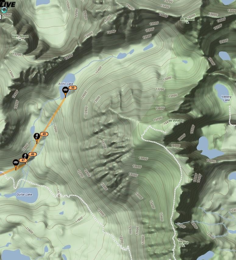
Verum audaces non gerunt indusia alba. - Ipsi dixit MCMLXXII
|
|
|
Re: HST - High Sierra Trail
|
Joined: Oct 2009
Posts: 2,251 Likes: 1
|
|
Joined: Oct 2009
Posts: 2,251 Likes: 1 |
?!. Huh? WTF? Oh, just looked at the webcam. Probably weather. 
Verum audaces non gerunt indusia alba. - Ipsi dixit MCMLXXII
|
|
|
Re: HST - High Sierra Trail
|
Joined: Nov 2009
Posts: 582
|
|
Joined: Nov 2009
Posts: 582 |
Don't be silly. What's a little lightning at 13K? 
|
|
|
Re: HST - High Sierra Trail
|
Joined: Feb 2011
Posts: 1,572
|
|
Joined: Feb 2011
Posts: 1,572 |
At 5:30 PM. This is interesting. According to his SPOT, he's free solo on the East Buttress. I know, he's gotta be in the MR chute, right? But check out the satellite view. Another good reason to at least leave the SPOT off for a while, huh?
Wherever you go, there you are. SPOTMe!
|
|
|
Re: HST - High Sierra Trail
|
Joined: Nov 2009
Posts: 1,037 Likes: 6
|
|
Joined: Nov 2009
Posts: 1,037 Likes: 6 |
Does anybody know what the light green/darker green demarcation line is on the west slope of Whitney? It passes through Mt. Russell & heads North/South.
I don't think it is the Zone, as I can't see it at Lone Pine Lake. You will need to select "Terrain".
Definitely not SEKI or Inyo Co boundaries. Could it just be some overlapping aerial/satellite survey equivalent of cut and paste? Clock is ticking- is Steve planning to sleep on the summit?
|
|
|
Re: HST - High Sierra Trail
|
Joined: Oct 2009
Posts: 2,251 Likes: 1
|
|
Joined: Oct 2009
Posts: 2,251 Likes: 1 |
Steve is apparently on the summit, 6 minutes ago. The hard way, I reckon. 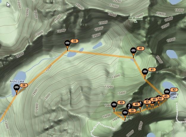
Verum audaces non gerunt indusia alba. - Ipsi dixit MCMLXXII
|
|
|
Re: HST - High Sierra Trail
|
Joined: Sep 2011
Posts: 1,158
|
|
Joined: Sep 2011
Posts: 1,158 |
Does anybody know what the light green/darker green demarcation line is on the west slope of Whitney? It passes through Mt. Russell & heads North/South.
I don't think it is the Zone, as I can't see it at Lone Pine Lake. You will need to select "Terrain".
Wagga, I think that's just a 3D shading effect you're referring to. The steep eastern escarpment shows up as darker because the light source used to render the topography is coming from the west. That would explain why it only shows up in terrain view. In some 3D mapping programs you can change the direction of the lighting.
|
|
|
|
|