|
0 members (),
148
guests, and
6
robots. |
|
Key:
Admin,
Global Mod,
Mod
|
|
 HST: High Sierra Trail and Pants Pass
|
Joined: Sep 2009
Posts: 8,509 Likes: 103
|
OP

Joined: Sep 2009
Posts: 8,509 Likes: 103 |
On Sept 3 - 8, I hiked solo from Crescent Meadow in Sequoia National Park, on the west side of the Sierra Nevada, to Whitney Portal on the east side. I followed the High Sierra Trail part of the way, but at Kaweah Gap, where the trail crosses the Great Western Divide, I left the trail and hiked cross-country northeast across Pants Pass. That route took me to the headwaters of the Kern-Kaweah River, where I eventually joined the trail descending that valley from Colby Pass. At Junction Meadow, where the Kern-Kaweah joins the Kern River, I reconnected with the High Sierra Trail, and hiked to the junction of the John Muir Trail. Following the JMT almost to Guitar Lake, I again hiked cross-country up the Arctic Lake drainage all the way to the Whitney-Russell pass. I had hoped to climb the north slope of Mt Whitney, but couldn't see a route that appeared safe for a solo hiker. I then went over the W-R pass to Iceberg Lake, loaded up on 3 quarts of water (using freezer Ziploc bags), and climbed the Mountaineers Route of Mt Whitney, so I could sleep overnight in the summit hut. Worst day was taking the Main Mt Whitney Trail to Whitney Portal -- my feet were killing me (toenail problems), and a blister afterward caused my entire left foot to swell. Next time I'll have bigger boots!
Going on such an adventurous route, and with family having concerns, I carried a Spot satellite signal unit so people could watch my progress, and just in case, I could summon help if I got into serious trouble. The nice part of carrying the unit is that I can see my route on a map after the trip. Here's a link (be sure to zoom in): Spotwalla Map
Starting out, my pack weighed about 26 lbs, carrying about 12 lbs of food, and a pound of fishing gear. I did not carry any water treatment tools, only a Snow Peak cup to dip and drink. I carried a Gatorade bottle, nearly empty most of the time, only filling it when I expected long stretches without water. Using my cup, I'd dip and drink at almost every stream crossing I encountered.
The pictures below, and many more, can be seen in this album: HST High Sierra Trail, Pants Pass
Day 1:
More pictures and report coming later....
|
|
|
Re: High Sierra Trail and Pants Pass
|
Joined: Dec 2009
Posts: 558
|
|
Joined: Dec 2009
Posts: 558 |
I wouldn't really want to climb the West side of Pants Pass. That would be a hard task.
A note on it's East side though. The chute you took down is indeed Pants Pass but there is a way you can cheat and take an easier route. When on top you walk along the ridge moving South for about 100 yards to another notch where easy slopes lead you down.
Over all sounds like a great trip. I like how you did not filter. My filter broke on me on day 30 of my trip and I did not filter again for 81 days with no problems.
|
|
|
 Re: High Sierra Trail and Pants Pass
|
Joined: Dec 2009
Posts: 213
|
|
Joined: Dec 2009
Posts: 213 |
Great show, Steve!
Isn't it so wonderful to get out there? (Duh.)
And best of all -- it shows you're still qualified as my potential Mountaineer's Route guide in 3 years! :D
6 days away from my own gig (rim to rim).
|
|
|
Re: High Sierra Trail and Pants Pass
|
Joined: Sep 2011
Posts: 1,158
|
|
Joined: Sep 2011
Posts: 1,158 |
What a great trip. I wonder how that Gatewood Cape would hold up in a storm pitched without stakes. I think you might have lucked out on that. We sure enjoyed speculating about your next move and few people thought you'd spend the night on the summit given the forecast. Your sunset shots are amazing. PS Is the Giardia medicine working?  
|
|
|
Re: High Sierra Trail and Pants Pass
|
Joined: Sep 2009
Posts: 8,509 Likes: 103
|
|
OP
Joined: Sep 2009
Posts: 8,509 Likes: 103 |
I'm pretty happy with the sunset shots. Really lucky to see sun through the slot since there was so much cloud cover. I was also lucky with the rain. Other hikers coming from other areas reported having several hours of rain several days. I only had rain on the second day mid-afternoon. So I just sat on a rock with the parka-tent over me and ate my lunch. Other days, there were only a few drops.
It was pretty tough setting up the tent without stakes. I'd hate to try it with rain coming down -- I'd probably do like that lunch, and just sit under it with it draped over me.
I talked with several hikers at Crabtree the night before the summit, telling them how nice it is on top, and tried to get them to meet me via the JMT. They were all finishing the JMT, so were well acclimated. One chickened out when a hiker told him the hut is freezing inside (...yeah, at noon when it is sunny out; but at night when it is cold out, the hut is returning all that solar heat!) Others chickened out thinking it would be too stormy. After my week of watching the 15k cloud ceiling and having little rain, I was confident it would be quite nice on the summit. And it was -- 60 F inside, even without the door!
Giardia? Try as I might, I couldn't find any. :grin: I am happy to certify that all the water along my route is clean and pure.
|
|
|
Re: High Sierra Trail and Pants Pass
|
Joined: Dec 2009
Posts: 558
|
|
Joined: Dec 2009
Posts: 558 |
Those are always special moments when the sun will dip down below the clouds and put on a wonderful show for about 5 minutes. Your lucky to get one of those a year.
|
|
|
Re: High Sierra Trail and Pants Pass
|
Joined: Sep 2009
Posts: 8,509 Likes: 103
|
|
OP
Joined: Sep 2009
Posts: 8,509 Likes: 103 |
Continuing on...

That first day, upon reaching Bearpaw High Sierra Camp, it wasn't quite 4 PM. I felt pretty strong, and looking at the map, Hamilton Lakes was just 4 miles ahead, only 600' higher. I didn't realize there was some significant loss and gain in elevation: -600, +1200. I made it -- it just took a while.
Check out Bearpaw on the satellite view "map".
|

The main cabin at Bearpaw. These hikers had come from Mineral King, and were spending two nights before heading out. Pretty relaxing!
Bearpaw is nice, with a fantastic view. But no stream or lake nearby. The people told me all summer reservations are gone in several hours the first day they become available.
|

This was the only deer I saw on the trip. She was right by the trail, using her hoof to dig for something good to eat.
|

I'm not sure what these berries are. Blueberries? Huckleberries? They tasted ok, but had lots of seeds.
Answer (Thanks to RogueP!): They are Sierra Currants (Ribes Nevadense) -- A gooseberry is in the currant family, I think. (See Google's images).
|

The Footbridge over Lone Pine Creek. It's a deep chasm, no way to get water here. There's even a remnant of an old bridge below that broke and fell.
|
Here's my camp site at the end of the day - on a sandy spot near upper Hamilton Lake. It was quite warm that night. There were about a dozen other campers here, all using tents. Not sure why people use tents when the weather is so nice!
Lots of small fish in the lake, too. Rules are catch and release. I was too tired to try fishing, and with so many people there, I figured the fish would be wary.

|
|
|
Re: High Sierra Trail and Pants Pass
|
Joined: Dec 2009
Posts: 558
|
|
Joined: Dec 2009
Posts: 558 |
Those berries are Sierra Currants(Ribes Nevadense).
I'm really surprised you didn't see deer at Hamilton Lake. This buck while I was there was a pest. He would chew on anything you left out and he was well trained to know when people have to use the bathroom. I had his company on both stays 5 days apart.
|
|
|
Re: High Sierra Trail and Pants Pass
|
Joined: May 2012
Posts: 18
|
|
Joined: May 2012
Posts: 18 |
This photos are fantastic! Brought back lots of memories from my trip across earlier this summer. What were you using for a stove?
|
|
|
Re: High Sierra Trail and Pants Pass
|
Joined: Sep 2011
Posts: 1,158
|
|
Joined: Sep 2011
Posts: 1,158 |
I wouldn't really want to climb the West side of Pants Pass. That would be a hard task.
A note on it's East side though. The chute you took down is indeed Pants Pass but there is a way you can cheat and take an easier route. Yeah, from Pants Pass drop down Gaiter Gully to Socks Saddle then over to Bandana Basin and take Tee-Shirt Traverse heading up Raincoat Ridge to Poncho Peak. Much easier and you get the whole outfit.
|
|
|
Re: High Sierra Trail and Pants Pass
|
Joined: Dec 2009
Posts: 558
|
|
Joined: Dec 2009
Posts: 558 |
Lol I didn't think I was that vague. The picture below displays what I mean. The small saddle to the left of the photo is the point that you start down on easy slopes. Or in the East to West climb aim for there and walk the ridge. You may have an easy class 3 move between the ridge and actual pants pass. 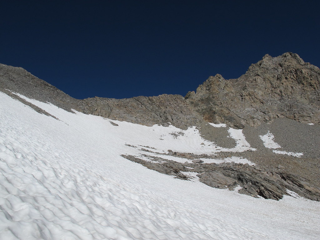
|
|
|
Re: High Sierra Trail and Pants Pass
|
Joined: Apr 2010
Posts: 659
|
|
Joined: Apr 2010
Posts: 659 |
Great photos. Looking forward to more installments of the report. HST is high on my list for next year.
Watching your style, I find myself slipping into ultra-light territory. Just got an ultralight shelter (Go-Lite was dumping all their Shangri-La 1's a week or so ago at hugely reduced prices; nest is heavy, so made a ground cloth out of Tyvek today as an alternative configuration). Now you have me pondering a Z-pack...after a few years of resisting....
|
|
|
Re: High Sierra Trail and Pants Pass
|
Joined: Aug 2010
Posts: 632
|
|
Joined: Aug 2010
Posts: 632 |
Steve...your trek is so fun to read...I have never even seen all the flowers and berries you photographed...I must not be as observant as you when I hike..first rule of the Sierra Club...never hike faster than you can enjoy your surroundings...at least that's what I was told is the first rule...hey didn't. You have a rope for your dip cup...you could have got a cup of water out of that deep chasm by lowering your dip cup...wow..wasn't your wife worried about you....I know I'd worry...I can't even imagine myself going it alone on the trails...great trip report ...thanks for sharing. Glad you got home safely to your wife and daughter and your Kitty too.
Last edited by lynn-a-roo; 09/29/12 09:38 PM.
Lynnaroo
|
|
|
Re: HST: High Sierra Trail and Pants Pass
|
Joined: Sep 2009
Posts: 8,509 Likes: 103
|
|
OP
Joined: Sep 2009
Posts: 8,509 Likes: 103 |
Connor, the stove is an " Esbit Titanium Folding Stove" SierraNevada: I didn't name that pass.  I think the idea is that people would need to slide down on the seat of their pants. I went up the slippery talus side, don't think I ever sat down. Slipped backward a full step several times. That was frustrating. I'll do a full write-up on that section in a later installment. Akichow, ultralight is nice--sure makes the walking more enjoyable. As for Tyvek: I got some once, but it weighs a ton, so threw it out. I have a box of Hefty 39 gallon trash bags, 1.1 mil, one bag weighs < 2 ounces. Slit the bag down both sides, makes a perfect ground cloth. Use a new one every trip. Lynn-a-roo, the Whitney east side trail doesn't have too many flowers -- well it does in the right season. West side trails have more, especially the trek to Bearpaw from Crescent Meadow. You and your friends should do that trip to Thousand Island Lake some summer. The High Route trail has lots of flowers. ...As for worried family: the Spot satellite unit provides a lot of security for me--If anything happens, at least they would know exactly where to look. (As for Kitty: It's 4 kitties now!  )
|
|
|
Re: HST: High Sierra Trail and Pants Pass
|
Joined: Sep 2009
Posts: 8,509 Likes: 103
|
|
OP
Joined: Sep 2009
Posts: 8,509 Likes: 103 |
Another installment...

Day 2 started with a long climb from Hamilton Lake. The trail starts at 8200', and climbs steadily to Kaweah Gap at 10,700'. The remarkable thing about the High Sierra Trail is that in most places, it was built with an amazingly even ascent rate. So the climb was steady, and not steep -- rather enjoyable, in fact, as I could watch Hamilton lake below, turning ever darker blue as I ascended.
This is a giant Juniper tree growing right by the trail. The cliffs of Valhalla can be seen behind the tree. (album view)
Clicking on most of the pictures will link to a larger view.
|

This short tunnel is the most remarkable engineering feature of the entire High Sierra Trail. About 1 1/2 mile and 1000 feet above Hamilton Lake, there is a massive narrow chute that cuts the granite. Builders originally erected concrete anchors and built a suspension bridge, but it apparently broke, probably under heavy snow. The anchors and concrete are still there, and so are several coils of monster cable -- with frayed ends.
This trail and tunnel extends horizontally back into the chute and out again along the opposite wall. I understand that in heavy snow years, this may be the last spot to open for hikers to pass, due to a steep icy snow bank blocking the trail. |

Looking back at the tunnel. Hamilton Lake is far below.
|

Pretty flowers along the trail. |

While I was busy taking closeups of pretty flowers and getting water from a stream, I cannot believe I completely missed this view! (This is not my picture. source) Before ascending to Precipice Lake, the trail overlooks Hamilton Lake, with a grand view of Valhalla.
Valhalla is the name of a Great Hall, in Norse or Germanic mythology, where heroes slain in battle lived eternally. |

Precipice Lake -- Jewel of the High Sierra Trail.
Truly a special place. Elevation is about 10,300', the lake is deep and blue, with one side bordered by 300' high cliffs. I took a good break here, climbing around to get pictures from various angles. It is difficult to choose the best ones from all the pictures.
This link is a view of Ansel Adams' "Frozen Lake and Cliffs" taken at Precipice Lake. |

As I climbed around Precipice Lake, I happened upon this -- a big spider having a bee for lunch. Fortunately I spotted it before breaking the huge web. I am amazed that such a creature could survive the winters here.
Click on the picture to see it even larger. |
While I explored the lake, about a dozen hikers came along -- a number I had camped with at Hamilton Lake, and others who had just come over the Great Western Divide at Kaweah Gap. It started raining at the lake, but lasted only long enough for me to put on my rain parka.
Hiking up to the gap was easy and gentle. There, I rested and talked with Emily and Stephanie from the SF Bay Area -- Emily returns to Hamilton Lake nearly every year. This trip she was introducing her friend to the beauty. They had day hiked to the gap, and would return to their camp at Hamilton Lake.
Another group of six men from Texas, who had also spent the night at Hamilton Lake, had been planning on doing the same as me -- leaving the HST, and heading over Pants Pass. The pass could be seen from Kaweah Gap, and it took them about ten minutes to decide to change course and head down the Big Arroyo, following the trail. Unfortunately, the next morning, when I talked to them, one of their group was having intestinal and headache problems, and decided to head back to the trail head, while the rest would move on.
|
One last look at Precipice Lake

|
|
|
Re: HST: High Sierra Trail and Pants Pass
|
Joined: Dec 2009
Posts: 213
|
|
Joined: Dec 2009
Posts: 213 |
Fun read, Steve! I like the way you've aligned pictures with your text. Not quite sure if it will work out that way for my own TR on rim to rim, but it's on my mind. (I have quite a few non-trail pictures.)
The first picture of the tunnel is AMAZINGLY just like the way the Supai Tunnel (1.7 miles down the North Kaibab Trail) looks. You'll see when I post it . . .
|
|
|
Re: HST: High Sierra Trail and Pants Pass
|
Joined: Apr 2012
Posts: 26
|
|
Joined: Apr 2012
Posts: 26 |
Great report so far Steve! Enjoyed every bit of it.
I have a question, how difficult was it to reserve a permit for the HST? Did you apply as soon as the permit office started taking applications?
Cody
|
|
|
Re: HST: High Sierra Trail and Pants Pass
|
Joined: Aug 2010
Posts: 632
|
|
Joined: Aug 2010
Posts: 632 |
Steve...I would like to know the answer to RadNar's question too (above).
Love all the photos ...the tunnel..spider..flowers..and especially Precipice Lake and how you pointed out Ansel Adams photo of this same lake.....hmmmm your photo is easily worth $192K....both your photos are equally as good as Ansel Adams' and maybe better.
Last edited by lynn-a-roo; 10/09/12 05:07 PM.
Lynnaroo
|
|
|
Re: HST: High Sierra Trail and Pants Pass
|
Joined: Dec 2009
Posts: 558
|
|
Joined: Dec 2009
Posts: 558 |
The High Sierra Trail is not a hard permit to get. I have never not just walked in and got one. I also have never seen the wall charts they have show full while at Lodegpole.
|
|
|
Re: HST: High Sierra Trail and Pants Pass
|
Joined: Feb 2011
Posts: 1,572
|
|
Joined: Feb 2011
Posts: 1,572 |
There are also several alternate access points/trails near enough to Crescent Meadow.
Wherever you go, there you are. SPOTMe!
|
|
|
|
|