|
1 members (dbd),
52
guests, and
8
robots. |
|
Key:
Admin,
Global Mod,
Mod
|
|
 Re: Trip & Hike Planning, June 1-4 2014
|
Joined: Nov 2009
Posts: 1,256 Likes: 2
|

Joined: Nov 2009
Posts: 1,256 Likes: 2 |
Chevy, I'd definitely recommend Dana, either as an acclimatization hike for a fourteener or a goal unto itself. It's probably the shortest/quickest way to get to 13K' in the Sierra, and the payoff is fabulous. Once you reach the crest, though, the wind can be wicked. My wife and 11 YO daughter did this with me a few years ago prior to a Whitney backpack, and we were up and down in what I remember as a relatively short, leisurely day. I can't recall the exact duration, but it was a late start and early finish, with lots of goofing-around time in the snow with our daughter and maybe an hour on the summit. I do remember that we got to the Whoa Nellie Deli before the dinner crowd hit.
I also think Little Lakes Valley is an excellent choice as the first hike of the trip for a family. Gorgeous scenery and not very demanding. Great way to start acclimating without pushing it.
I know you have your accommodations in Mammoth already set but in the future you might want to consider renting a condo. The inventory is heavily glutted there in the summer and they can be dirt-cheap. Certainly the best way I've found to sleep high in comparative luxury in the Sierra.
|
|
|
Re: Trip & Hike Planning, June 1-4 2014
|
Joined: Oct 2010
Posts: 453 Likes: 1
|
|
Joined: Oct 2010
Posts: 453 Likes: 1 |
Looks like I was wrong. Someone found NAP passable but OAP not. http://www.summitpost.org/phpBB3/viewtopic.php?t=67704If you're acclimated, Dana is very easy, probably the easiest 13er you'll ever do.
Under the same snow conditions, I don't see any difference from New to Old Army. I only find New Army safer under dry conditions because the trail isn't washed out, but that's just my opinion.
The further Northeast you head on Langley, the more technical it will get. You should not encounter anything harder than Class 3 for a few short sections, if that. There is no preferred way up there. Even in the Summer, there are so many use trails...pick what feels best for you.
Depending on your provider, there may be cell coverage. I could not call but could text.
|
|
|
Re: Trip & Hike Planning, June 1-4 2014
|
Joined: Aug 2012
Posts: 671
|
|
OP
Joined: Aug 2012
Posts: 671 |
Thanks again for all the other suggestions regarding alternate hikes. They'll come in handy in the coming months, if not on this trip! The Saddlebag Lake hike looks particularly scenic, but the resort website says that the road is still closed. I emailed them to see if this is actually the case. Looks like I was wrong. Someone found NAP passable but OAP not. Thanks for the heads up, as well as the info on the routes approaching the summit of Langley. ..you might want to consider renting a condo... Thanks - not sure why I hadn't thought of that! We're hiking Clouds Rest in August. I'll have to think about a condo for that trip. I spoke with my father-in-law last night after discussing the options, I think we've finally made a decision. The plan is for us to hike Mt. Dana as our 'peak' then hike MWMT up to trail camp so that he can gain some familiarity with the trail. He will be back out here in early October, so I hope getting him on that trail will ease his anxiety a bit. I was thinking it might be fun/useful to practice with an ice axe and crampons while in the Mammoth or Yosemite area, then do the same at Trail Camp. If the snow comes early this fall, it would be nice to have some more experience under our belts. Is Dana a place where we could practice, assuming there's enough snow? Are there any spots closer to Mammoth? The gondola on Mammoth Mtn doesn't open until June 13. A customer service rep told me we aren't allowed on the ski slopes.
|
|
|
Re: Trip & Hike Planning, June 1-4 2014
|
Joined: Nov 2009
Posts: 1,256 Likes: 2
|
|
Joined: Nov 2009
Posts: 1,256 Likes: 2 |
You'll be approaching Dana from the north most of the way, so you'll have the best possible chance of catching snow. The beginning of the hike takes you through meadows on the south side of Tioga Rd, just behind the Ranger hut (you really don't need to enter the park - just use the roadside parking on the north side of Tioga outside the entrance station). As I recall, there are a couple of extended slopes of maybe 30 degrees you'll need to negotiate that would be your best opportunity if the snow is deep/firm enough and not badly suncupped. As I mentioned, the wind gets pretty wicked up high along the crest, so I doubt you'll find any snow to speak of above 12K'. Your best shot of finding snowpack to work with would likely be a couple of miles or so into the hike, at around 11-11.5K'.
Once you're above 12K', the reasonably well-defined use trail kind of disappears into talus and scree. The final approach to the summit - maybe 500 vf - is pick-your-poison. Be careful on that last incline (and descent) on the talus - lotta unbalanced rock and more ankle-breakers than you might suspect.
|
|
|
Re: Trip & Hike Planning, June 1-4 2014
|
Joined: Apr 2010
Posts: 659
|
|
Joined: Apr 2010
Posts: 659 |
In recent years, the Park has been putting flags and markers to help with the last 500'. It is slowly moving from use trail/route to real trail territory. Don't know if they've done it this year yet, though.
|
|
|
Re: Trip & Hike Planning, June 1-4 2014
|
Joined: Aug 2012
Posts: 671
|
|
OP
Joined: Aug 2012
Posts: 671 |
I am working on a trip report, but here's an updat: We hiked to Mono Pass Monday and spent a couple of hours in the area brushing up on our ice ax and crampon use. Monday afternoon I took the family to Devil's Postpile then up to Mono Lake to watch sunset. We hiked to Outpost Camp Tuesday, then summited Wednesday morning and returned to the portal Wednesday afternoon. I just started looking through my photos. Here's my favorite so far: 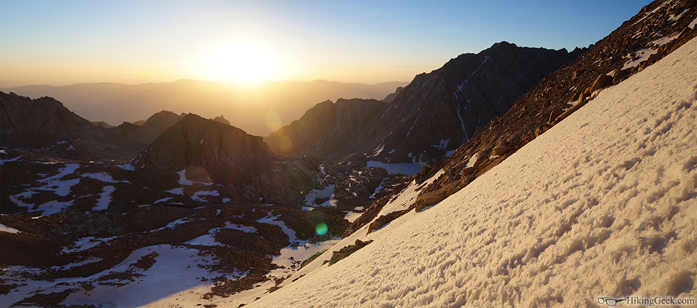
|
|
|
Re: Trip & Hike Planning, June 1-4 2014
|
Joined: Apr 2012
Posts: 579 Likes: 3
|
|
Joined: Apr 2012
Posts: 579 Likes: 3 |
Hi Chevyll,
Congrats to you and your crew. I'm guessing both you and your father-in-law are stoked. Great picture, great adventure:-)
John
|
|
|
Re: Trip & Hike Planning, June 1-4 2014
|
Joined: Aug 2012
Posts: 671
|
|
OP
Joined: Aug 2012
Posts: 671 |
Thanks John!
I'm glad I was finally able to get him up there. We've been talking about doing it for the last 3 years and the timing never worked out for us.
I took 500+ photos over the 4 days. I will post them as soon as I have the time to go through them.
Thanks again for your suggestions and help planning the trip!
Lyndon
|
|
|
Re: Trip & Hike Planning, June 1-4 2014
|
Joined: Sep 2011
Posts: 1,158
|
|
Joined: Sep 2011
Posts: 1,158 |
Awesome. Glad you were able to stick with Plan A)4.b.IX.c.  That's a good lesson for everyone. Get lots of ideas but be flexible and it all works out somehow. Nice photo! How was the chute? I guess I should wait for the TR.
Last edited by SierraNevada; 06/05/14 06:52 PM.
|
|
|
Re: Trip & Hike Planning, June 1-4 2014
|
Joined: Aug 2012
Posts: 671
|
|
OP
Joined: Aug 2012
Posts: 671 |
Awesome. Glad you were able to stick with Plan A)4.b.IX.c. lol  I really enjoy the process and planning and researching different options. I also don't like being stuck without options if something goes wrong.
How was the chute? I guess I should wait for the TR.
Going up wasn't too bad. I struggled a bit due to poor conditioning. I didn't get cramps, but felt like I was on the verge. My hamstrings were sore from the 2 hrs of playing in the hills by Mono Pass before we even started. We also left the switchbacks to soon and had to backtrack... we probably added 20 minutes of unnecessary strenuous hiking. Standing at the top and looking down was a bit intimidating though! It's my most memorable Whitney hike and I'm thankful for the experience. It was warmer than expected, so the snow wasn't too hard even @ 4:00 am when we left Trail Camp. When we were headed down @ 11, the snow was very soft, but I did hit an icy section and self arrested (twice) as soon I started to pick up speed.
|
|
|
Re: Trip & Hike Planning, June 1-4 2014
|
Joined: Aug 2012
Posts: 671
|
|
OP
Joined: Aug 2012
Posts: 671 |
Here's a video of the trip up and down the chute. It is very shaky and kinda unwatchable, but I'm glad I was able to capture it in some manner. I used a gorilla pod to attach and old digital camera to my chest strap. I've done something similar on car cruises and it worked fine. I didn't realize how much I would be bounced around. ... it might be time to invest in a GoPro. https://www.youtube.com/watch?v=s3z43a5frnM&feature=youtu.beWe were both very conscious of our speed headed down, trying to go as slow as possible and stopping often. The glissade took about 10 mins including breaks, then another 15 minutes to walk over to the trail. I was surprised at how tiring braking was - I had never done it over such a long distance. I've finished editing/resizing the photos, I just need to upload them.
|
|
|
|
|