Mt Whitney Webcam
Mt Williamson Webcam
Who's Online Now
0 members (), 148 guests, and 6 robots.
Key: Admin, Global Mod, Mod
Previous Thread
Next Thread
Print Thread
Avalanche on the North Fork Lone Pine Creek
#49641 04/23/17 12:24 PM
Joined: Sep 2009
Posts: 8,509
Likes: 103
S
Steve C Offline OP
OP Offline
S
Joined: Sep 2009
Posts: 8,509
Likes: 103
This reported April 22, 2017, on the Eastern Sierra Avalanche Center website.

Avalanche on Mt Whitney Mountaineers Route

Reported at 9300' elevation, puts it in the canyon below Lower Boy Scout Lake, about the elevation of the Ebersbacher Ledges. Form the picture, it appears the slide came down into the canyon from the north-facing slope above the canyon.

Type: Wet Loose Point-release     Slope: 45 degrees     Crown Height: 1 ft.     Aspect: North
Avalanche Width: 100 ft     Avalanche Length: 500 ft     Partial burials: 2

More info:
Estimated R2-3, D2 avalanche in the initial gully of the mountaineers route up mt Whitney. Location 1.3 miles from trailhead parking, elevation 9300 ft. We encountered several groups who had been partially buried in the slide. Large 2 ft deep by 25 ft square ice boulders carried by slide. Several injuries, one requiring helicopter evacuation. Cause determined to be warning rock and running water at the base of the snowpack creating a perfect bed surface. Extremely warm conditions at around noon; guess of around 50-55 F air temps when we got there.

Two pictures: click on the pic for enlarged view

This shows the rescue helicopter, with its stretcher hoist mounted.
 

Re: Avalanche on the North Fork Lone Pine Creek
Steve C #49642 04/23/17 01:58 PM
Joined: Feb 2011
Posts: 1,572
Offline
Joined: Feb 2011
Posts: 1,572
Note to reporters: this was NOT on the Mountaineer's Route. This was on the North Fork of Lone Pine Creek, the approach to the the Mountaineer's Route and a dozen or two other routes on and around the east face of Whitney.


Wherever you go, there you are.
SPOTMe!
Re: Avalanche on the North Fork Lone Pine Creek
Steve C #49653 04/23/17 11:06 PM
Joined: Jun 2014
Posts: 114
Offline
Joined: Jun 2014
Posts: 114
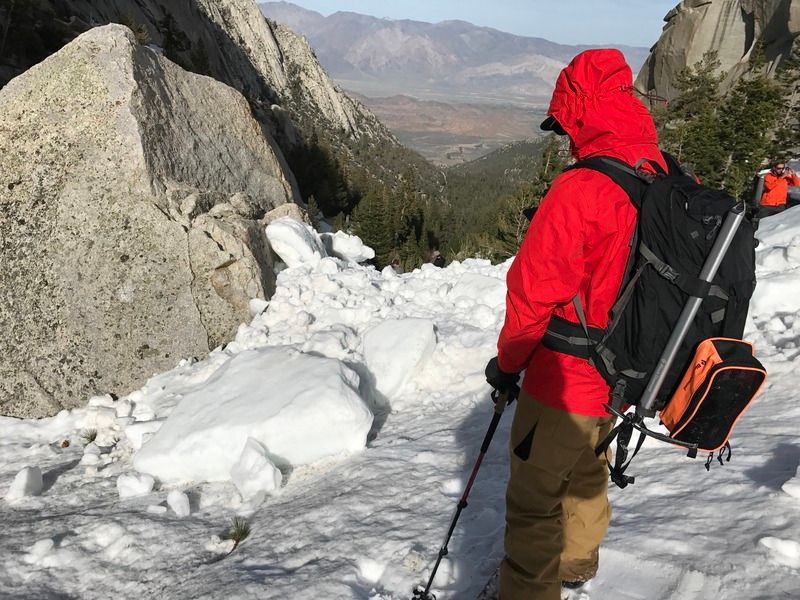
I saw the aftermath of this avalanche later in the day.

The avy observation is correct - we were actually sitting at the Pizza Factory next to the party who wrote and posted the report that evening.

We were lucky that we hiked through this section at 5 AM, when it was still cold. The avy happened in late morning, a few hours of warming after the sunrise.

From what I heard, the slide came down near a party of four. There was one person partially buried and injured his foot/leg. A party of two were able to shield themselves behind a large boulder, and then came out to dig up the buried victim. Another party came along (there were 5 of them I believe, they wrote the avy report) and stayed with the injured person until the rescue chopper picked him up around 530 PM. A SAR ground team also came to help. That is a long time to wait to be extracted - keep that in mind when planning your outings!

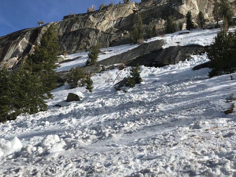
The North Fork of Lone Pine Creek has very steep rock walls on both sides between 9000-10000 feet. It's a huge terrain trap and the slabs aren't going to hold the snow much longer as the days get warmer and the nights are not cold enough for refreezing below 9000-10000 feet or so. There is water running between the rock and the snow on top of it, undermining the snow and creating a layer of lubrication. Point releases and wet slides were prevalent below, at, and above treeline, on all aspects.

Everyone was lucky on Saturday - this could have happened to any of us. When going out in these conditions, please wear a beacon, probe, shovel, and first aid gear - and know how to use all of these things! Take an avalanche class and Outdoor Emergency Care (OEC) or Wilderness First Aid course.


The slide path and debris. The avalanche crown is visible on the right side of the dark rock in the center. That entire rock was covered in snow/ice that slid.


Size of debris ranged from microwave- to refrigerator-sized chunks

Last edited by goldscott; 04/23/17 11:13 PM.
Re: Avalanche on the North Fork Lone Pine Creek
Steve C #49654 04/24/17 05:49 AM
Joined: May 2013
Posts: 9
N
Offline
N
Joined: May 2013
Posts: 9
On our way down on Sunday around 4:45pm we witnessed an other, smaller avalanche (about 30ft wide and 1ft deep) just 100 ft above the one that injured the guy on Saturday. The snow above the canyon seemed very unstable with water coming down everywhere. Please be careful if you decide to skip the ledges.

Last edited by nemeseri; 04/24/17 05:50 AM.
Re: Avalanche on the North Fork Lone Pine Creek
nemeseri #49666 04/24/17 03:06 PM
Joined: Aug 2011
Posts: 581
Likes: 10
S
Offline
S
Joined: Aug 2011
Posts: 581
Likes: 10
Calicokat fell through a snow bridge on the N. Fork Gully a few weeks back. His feet snagged on some willows keeping him from being sucked under the snow into the creek. Lilbitmo helped extract Calico.

Unsurprisingly, it seems that this big snow year has made Whitney all the more treacherous this season.

Stay safe or wait until the snow melts folks.


@jjoshuagregory (Instagram) for mainly landscape and mountain pics
Re: Avalanche on the North Fork Lone Pine Creek
Snacking Bear #49687 04/25/17 09:23 PM
Joined: Sep 2009
Posts: 8,509
Likes: 103
S
Steve C Offline OP
OP Offline
S
Joined: Sep 2009
Posts: 8,509
Likes: 103
CHP posted a video of the avalanche rescue:

https://www.facebook.com/276737786013059/videos/442622306091272/

Re: Avalanche on the North Fork Lone Pine Creek
Steve C #49737 05/02/17 10:35 AM
Joined: Jun 2014
Posts: 114
Offline
Joined: Jun 2014
Posts: 114
My friend Sarah sent me this article, written by Bob Rockwell in 2006 and extremely relevant, especially this season. Circle number 2 on the second page is exactly where this avy occurred.

http://www.californiamountaineer.net/WhitneyAvalancheAvoidance04282006.pdf

Re: Avalanche on the North Fork Lone Pine Creek
goldscott #49738 05/02/17 03:44 PM
Joined: Sep 2009
Posts: 8,509
Likes: 103
S
Steve C Offline OP
OP Offline
S
Joined: Sep 2009
Posts: 8,509
Likes: 103
Bob R first wrote and posted that on the Whitney Portal Store forum, but it got so much flak from trolls and such that he took it down. I am glad it is still available. Bob R doesn't get out anymore, which is a huge loss.

One place that is missed on that map is the area just south of Iceberg Lk. A number of years ago a group reported being buried inside their tent during the night while camped there during a storm. Several were in the tent, and one ended up on top of the other. Top man wasn't buried too much, so once he got free, that provided a passage for the one well underneath to get out!


Link Copied to Clipboard
Powered by UBB.threads™ PHP Forum Software 7.7.4
(Release build 20200307)
Responsive Width:

PHP: 7.4.33 Page Time: 0.163s Queries: 30 (0.156s) Memory: 0.6105 MB (Peak: 0.6881 MB) Data Comp: Off Server Time: 2024-04-20 02:26:22 UTC
Valid HTML 5 and Valid CSS