|
|
|
0 members (),
99
guests, and
8
robots. |
|
Key:
Admin,
Global Mod,
Mod
|
|
 Old Army Pass conditions
|
Joined: Jul 2012
Posts: 3
|
OP

Joined: Jul 2012
Posts: 3 |
Hi all,
I plan to climb Mt Langley via Cottonwood Lakes/Old Army pass this weekend. Does anyone know the conditions at Old Army pass? Ie, are crampons/axe necessary or overkill?
Thanks much,
Dave
|
|
|
Re: Old Army Pass conditions
|
Joined: Oct 2010
Posts: 453 Likes: 1
|
|
Joined: Oct 2010
Posts: 453 Likes: 1 |
|
|
|
Re: Old Army Pass conditions
|
Joined: Sep 2011
Posts: 93 Likes: 7
|
|
Joined: Sep 2011
Posts: 93 Likes: 7 |
Please post a trip report when you return if you can. I'm heading up Langley at the end of the month (wow that's in like 2 weeks!) with some friends and would love to know what it's like up there right now.
=) tif
|
|
|
Re: Old Army Pass conditions
|
Joined: Jul 2012
Posts: 3
|
|
OP
Joined: Jul 2012
Posts: 3 |
Thanks very much. Good to know I can save the weight.
-Dave
|
|
|
Re: Old Army Pass conditions
|
Joined: Jul 2012
Posts: 3
|
|
OP
Joined: Jul 2012
Posts: 3 |
Sure - I'll post a TR when I get back!
-Dave
|
|
|
Re: Old Army Pass conditions
|
Joined: Oct 2010
Posts: 453 Likes: 1
|
|
Joined: Oct 2010
Posts: 453 Likes: 1 |
Please post a trip report when you return if you can. I'm heading up Langley at the end of the month (wow that's in like 2 weeks!) with some friends and would love to know what it's like up there right now.
=) tif Old Army Pass is the last place with snow. It is completely bone dry. All the little creeks are bone dry. The only thing you'll have to worry about in two weeks is rain, and strong winds. There are no other obstacles to impede your progress aside from the weather and the altitude. EDIT: and the mosquito.
|
|
|
Re: Old Army Pass conditions
|
Joined: Sep 2011
Posts: 93 Likes: 7
|
|
Joined: Sep 2011
Posts: 93 Likes: 7 |
Ugh the evil mosquito! (I had one try to make out with me in Yosemite last week and ended up with a SUPER plumped up lip for ~12 hrs)
My other concern with Old Army Pass is route finding, on many of the trip reports I've read, people have noted having difficulty finding the 'trail' beginning at the lakes heading up. Anyone have any suggestions for geting on the right route up the pass?
=) Tif
|
|
|
Re: Old Army Pass conditions
|
Joined: Oct 2010
Posts: 453 Likes: 1
|
|
Joined: Oct 2010
Posts: 453 Likes: 1 |
Tif,
Route finding is easy-peasy. Although the trail isn't maintained any longer, it still looks like a well defined use-trail. IGNORE THE CAIRNS that lead directly up the pass.
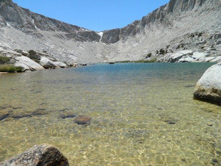
Remember that you have to bank way left, then back again. Look at the picture. You'll be on top of those slick looking slabs on the bottom left, then you'll be making your way on that obvious ledge in the cliffs leading to the snow. The exit of Old Army is just to the left of that snowfield.
|
|
|
Re: Old Army Pass conditions
|
Joined: Sep 2011
Posts: 93 Likes: 7
|
|
Joined: Sep 2011
Posts: 93 Likes: 7 |
Thanks for the info! I read in several places that getting on the right trail from the lakes can be tough as there are LOTS of use trails. Good to know about ignoring the cairns up the chute though!
=) tif
|
|
|
Re: Old Army Pass conditions
|
Joined: Sep 2009
Posts: 8,509 Likes: 103
|
|
Joined: Sep 2009
Posts: 8,509 Likes: 103 |
> I read in several places that getting on the right trail from the lakes can be tough as there are LOTS of use trails.
You may be mixing this area with the many use trails leading toward Mt Langley once you get above "old" or New Army Pass and leave the trail climbing ~400' elevation northward toward Mt Langley. Once you pass the 3700M (12,000') contour on the map, there are lots of use trails leading through the "kitty litter" decomposed granite terrain.
The unmaintained trail is shown on the map, where it travels along the north shore of Lake 4. You can't miss it there.
|
|
|
Re: Old Army Pass conditions
|
Joined: Sep 2011
Posts: 93 Likes: 7
|
|
Joined: Sep 2011
Posts: 93 Likes: 7 |
That map helps so much!! I definitely heard/read of the maze of use trails above the pass, but also read of people having a hard time getting started at the bottom of the pass too due to 'fishing' trails (i suppose from folks running around the lake to find the best fishing spot!)
Now though I know which way to start to find the 'real' trail up the pass.
You rock!
=) tif
|
|
|
Re: Old Army Pass conditions
|
Joined: Sep 2009
Posts: 1,253
|
|
Joined: Sep 2009
Posts: 1,253 |
It's not getting to the pass that is ambiguous; it's from about 12,300' level where trail go off in about 30 directions. Your goal is the southwest corner of the mountain for the class 2 route to the summit...me I like the 20 feet of light class 3 climbing through a slot, which saves about 20 minutes. How you choose to get there is up to you.
Me, I like the steep and direct route, which will be to your way to your left.
|
|
|
|
|
|
|