OP

admin
Joined: Sep 2009
Posts: 108 |
Posted by Wayne, 06-27-04This is old hat now to many on the Board, but we have had many newbies this past year.
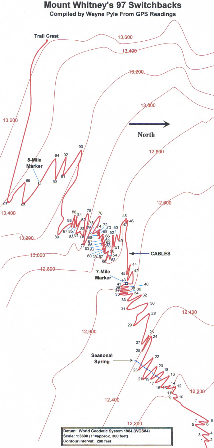
Until two years ago, there was a lot of confusion about the number of switchbacks between Trail Camp and Trail Crest. I saw counts ranging from 95 to 100. Why was the count not known? Anyway, I was a bit bugged by the confusion, so I set out to count the switchbacks myself, but to do it differently than anyone had done before.
I stopped at each switchback, pressed the "mark" button on my Garmin GPS 12, and then input the altitude shown on my Suunto altimeter. It took me several hours to go the 2.2 miles from Trail Camp to Trail Crest, but when I got to the top of the trail, my GPS showed 97 switchbacks.
When I got back home, I set out to map the trail, using, of all things, an Excel spreadsheet. I used the column and row lines as latitude-longitude lines. For contour lines, I used Topo software from National Geographic. I treated each contour line as if it were a separate trail, and recorded latitude-longitude data which I manually transferred to my Excel spreadsheet. After I connected all the dots, I used many photos to more closely match the switchbacks to the terrain. I also gave Bob R. a copy and asked him for his help in making corrections. Being the man he is, he was a great help!
Well, after dozens of painstaking hours, the map finally materialized, which you can see at Map of the 97 Switchbacks. (Note: it is an MS Excel file) Special thanks to Bob R. for generously posting it on his personal Website. Edit: a jpg image can be viewed/printed here.
The map is by no means perfect, but it gives a fair rendition of the Mt. Whitney Trail from Trail Camp to Trail Crest. I've also included trail mileages, based on the book, Mount Whitney Guide for Hikers and Climbers, by Paul Hellweg and Scott McDonald. They show 6.3 miles to Trail Camp from the trailhead. I allow one-tenth of a mile from Trail Camp to the start of the switchbacks. Doug Thompson's Mount Whitney Mountain Lore From the Whitney Store, shows 2.2 miles from Trail Camp to Trail Crest, but only 6.0 miles from the Trailhead to Trail Camp. I don't know which book is right, but both books agree that the 97 switchbacks are 2.2 miles.
The map was designed to be printed on legal-size paper, 8 1/2 x 14 inches. However, it can be printed on 8 x 11 paper.
All my GPS data is shown on a second spreadsheet in the Excel workbook, in case you would like to see it.
Happy switchbacking! 
Click on the image to see a full-size picture:

Posted by Karl Keating, 06-27-04Many thanks for this otherwise thankless task! I am impressed at your industry.
Posted by Sierra Sam, 06-27-04That's fantastic - how about doing the MR next?
Posted by kim, 06-28-04wow, that's very impressive. i'm tired just looking at it! they're not what i imagined-a little more spread out.
Posted by Wayne, 06-28-04Thanks, kkeating and kim. Sierra Sam, since I was on the lower part of the MR a few weeks ago with Bob R and Richard Piotrowski when we did Thor, I captured the route in my GPS. However, the MR would require a lot of terrain mapping to make it useful, which I am not prepared to do. Superimposing the route on a good topo might be helpful, with lots of annotations. We'll see.
Kim, we look forward to your trip report!
Posted by sipako, 06-28-04I don't see it on my browser. What is the underlying data format?
Posted by Scott M, 06-28-04The switchback layout is an Excel file.
Posted by ScottHiker, 06-28-04Wayne,
This is great! I just printed it out on our color printer here at work (8.5 x 11). I plan to put this into my California's Fourteeners book so I have it the next time I climb Mt. Whitney.
Posted by norweejunwood, 06-28-04wayner
really cool. appreciate the effort.
Posted by ellenclary, 06-28-04When I first read this report I thought it was an incredibly obsessive thing to do. Then I took a look at it. This is really useful as it's great having this detailed a map of the switchbacks. It shows where the cables are located, and where that spring is.
Ellen
Posted by elbin, 06-29-04what is the secret to viewing this?
I didn't think I was this lame, but I can't figure it out. all I get is code when I click the link, and a big blank graph when I open the link in Excel.
help me into the 21st century please.
Posted by Tucker, 06-29-04I have to add my words of appreciation to the chorus. I kept count on my way up in 2001, and it was oddly motivating to know that I only had X amount more to go - and it made for great conversation with the folks you play leap frog with on them ("Hey no worries, only 35 more to go - we're over half way there!") I will be printing this out and carrying it with me in September.
Side note, is it only me and my admittedly odd imagination, or when you're standing above the switchbacks and heading back down, watching all of the people descending and ascending infront of you, does it look like one of those old fashioned wooden marble toys where you roll the marbles down and watch them all bang into each other as the go down the wooden chute and curves?
Posted by AlanK, 06-29-04elbin -- follow the link. For me, the map is visible using Internet Explorer but the linked page looks like gibberish using Netscape. However, in either case, saving it to your disk gives you the Excel workbook, which you can open directly with Excel.
Posted by ellenclary, 06-29-04The way I viewed the file was to right-click on the link and save the file to my hard disk, then start Excel and open the saved file.
Posted by elbin, 06-29-04hooray!
the 21st century... everything is so shiny and beautiful!
Excellent map, very interesting. Although I believe if I was counting switchbacks when I was up there last week I would have gone crazy. As it was, having long since lost count, I slipped into an altered state of conciousness... my breathing was timed to my pulse and my steps were timed to my breathing, sweat dripped off my skin in tempos synchronized to ageless circadian rhythms... the moment crystallized and suddenly the world made sense... the popularity of pickles, why women's buttons are on the other side of their shirts, paper versus plastic, George W... it all became clear.
Great map, great hike.
Posted by fish395, 06-29-04Womens buttons are on the other side of their shirts?Where have I been?Oh yea,the map is great too!Seems to me when I went up a few weeks ago I counted 400 switchbacks.Maybe it just felt that way
_________________________
"At least I have a Peak named after me"
Posted by Wayne, 06-30-04Sierra Sam, I just finished transferring the way-points from my GPS to TOPO! from my recent trek up the MR. I discovered that I was not able to map the Ebersbacher Ledges, because, being so close to the walls of the ledges, I was only able to acquire one or two satellites. Therefore, no GPS map! You need at least three satellites to make a horizontal map. Maybe someone else can find the time to be at the Ledges or up in the Couloir, Notch, or top chutes when at least three satellites can be acquired. Easier said than done!
Posted by gatormom, 07-09-04Wayne,
Wonderful job, it's very impressive.
What exactly is "cables" between SB 45 and SB 46 mean? How wide is the trail on this part the Whitney Trail?
Posted by Wayne, 07-10-04Hi, gatormom! I emailed you a photo of the cable section. The trail between switchbacks 45 and 46 cuts across a rock face. There is a little exposure, which can be problematic to some with acrophobia. Otherwise, it is a highway during the latter part of the summer, about four feet wide. You can use the cables as a handrail, but most just walk on by. When there is a lot of snow, and the cables are still up, some hikers walk on the outside as they hold on to the cables. Since you plan to do the switchbacks later this summer, the trail should be clear. Happy switchbacking!
Posted by VersatileFred, 07-12-04Hi Wayne,
Thanks for the information. I downloaded the file earlier this year and took a printed copy of it with me on the trail last Saturday.
I noticed two turns around switchback #8 that were less than 135 degrees that may have been the difference between 97 and 99. A group that passed me near the first switchback were counting them out loud and I remember that my count was all of a sudden two less than theirs. My count correlated with yours at the cables, and it was good when I could tell the newbies in my group that there were no more switchbacks (just a long traverse) before Trail Crest.
Fred
_________________________
Orientation Notes for Whitney First Timers
Posted by Wayne, 07-13-04VersatileFred, from the photos in my collection, I can see that there used to be fewer switchbacks--95 to be exact. Switchbacks 92 and 93 are newer additions, although I don't know when the Forest Service, or whoever, added the 92 and 93 shown on my map. You can pinpoint the older switchback by extending lines from SB 91 thru 92, and another line from SB 95 to 94. The older SB is where the two lines intersect. I suspect part of that old segment collapsed long ago, making it too dangerous for hikers.
When I did my GPS readings, I went by the rule of thumb that a "switchback" had to be less than a 90-degree turn. Certainly the trail has to switch back in direction. There are turns, as you've observed, that are greater than 90 that I did not count. It's interesting that you said 135 degrees. Thanks for posting!
Posted by VersatileFred, 07-13-04Wayne,
I think that we are down to semantics in our definitions. If you add "the angle between trail segments" with "the angle of change in your course at their junction" you get 180 degrees. When I said there were two turns that were less than 135 degrees I was referring to the change in course angle. Another way of saying that would be that the angle between the segments was over 45 degrees (my tolerance threshold for 0 degrees) and probably did not count as switchbacks. Anyhow, both of the turns that I was referring to were about 90 degrees in succession (either way you measure the angle) so they did not count as switchbacks even though together the 180 degree course change has the same effect as a single switchback.
Hope that clarifies my last post.
Fred
_________________________
Orientation Notes for Whitney First Timers
1088384340 14064
|