|
0 members (),
95
guests, and
11
robots. |
|
Key:
Admin,
Global Mod,
Mod
|
|
 Re: Everest Gigapan image
|
Joined: Dec 2009
Posts: 213
|

Joined: Dec 2009
Posts: 213 |
I've decided -- the Everest picture is cooler than my spaghetti w/hot sauce, oregano, & garlic that I'm eating right now. (Even considering the glass of merlot accompanyng it.)
|
|
|
Re: Everest Gigapan image
|
Joined: Sep 2009
Posts: 8,509 Likes: 103
|
|
Joined: Sep 2009
Posts: 8,509 Likes: 103 |
What an amazing picture! Two other WZ members forwarded the link to me so we might post it here. Thanks, Fishmonger, for posting it.
Fishmonger wrote:
> you can see climbers all the way up the flank to the South Col when you zoom in.
Sorry for my not knowing... is Everest the peak in the center between the two closer peaks? And it the South Col the steep slope with the broken glacier area on that peak? I can see climbers and tents just to the left of that broken area, from the bottom, up to about half way.
Also, if you rotate the view all the way to the right and then zoom in, you can see the blue-roofed buildings of the whatever location that is.... base camp?
|
|
|
Re: Everest Gigapan image
|
Joined: Nov 2009
Posts: 1,037 Likes: 6
|
|
Joined: Nov 2009
Posts: 1,037 Likes: 6 |
Big E is the black big mother behind ( and tallest)
Lhotse (South Peak) is 4th tallest peak in world (although one could argue it is really just part of the Everest massif). It has the crenelated top straight ahead up the end of the Western Cwm
South Col is the pass or saddle between E and Lhotse. it is the site of current high camps from where summit bids start, although in past, some camps ( and even a few bivies) have been set higher. South Col is the edge of the Death Zone,
Nuptse (West Peak) is on the walled peak seen end-on on the right
Over to the left:
Hanging glacier is the Lho La ( South Pass)
behind it is Changtse ( North Peak) and the prominent saddle between it and Everest in the North Col - scene of where Mallory and the Brits started the show in 1921, 1922, and 1924 (when Mallory died).......
|
|
|
Re: Everest Gigapan image
|
Joined: Jan 2010
Posts: 1,034
|
|
OP
Joined: Jan 2010
Posts: 1,034 |
this photo helps a little to explain what's what 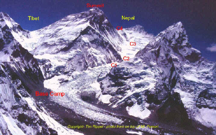 The peak where it states Nepal is Lhotse. Base camp is to the bottom left of the panorama, lots of tents there. Then above it the route follows the ice fall in the glacier (several climbers can be found to the left of the ice fall on the way up), then it enters the big valley above called the Western CWM. Above that valley which is hidden from view in the panorama, the route hugs the Lhotse face and heads diagonally up to the saddle between Lhotse and Everest, where you can find quite a number of climbers when zooming in. The rest of the route to the summit is hidden from this angle.
|
|
|
Re: Everest Gigapan image
|
Joined: Nov 2009
Posts: 249 Likes: 1
|

Joined: Nov 2009
Posts: 249 Likes: 1 |
...
Sorry for my not knowing... is Everest the peak in the center between the two closer peaks? And it the South Col the steep slope with the broken glacier area on that peak?
...
Everest is on the left, the view to the summit is up the west ridge. The middle peak is Lhotse. The right peak is Nuptse. The glacier ice is the Khumbu icefall. The South Col is in the notch between Everest and Lhotse. http://www.alpineascents.com/everest-map.aspDale B. Dalrymple
|
|
|
Re: Everest Gigapan image
|
Joined: Sep 2009
Posts: 8,509 Likes: 103
|
|
Joined: Sep 2009
Posts: 8,509 Likes: 103 |
Thanks for identifying the spots! Here's a picture from dbd's link that also helps:  What is the village named below Base Camp, that can be seen in the right side of the gigapan picture? (Scroll all the way right, then zoom in two clicks, look for the blue roofs). Here is a clip from the original: 
|
|
|
Re: Everest Gigapan image
|
Joined: Jan 2010
Posts: 1,034
|
|
OP
Joined: Jan 2010
Posts: 1,034 |
I had no idea these buildings existed :-) Google doesn't seem to find the answer either, or I am using the wrong terms to search.
Probably a Starbucks or a Patagonia store in there.
|
|
|
Re: Everest Gigapan image
|
Joined: Sep 2009
Posts: 8,509 Likes: 103
|
|
Joined: Sep 2009
Posts: 8,509 Likes: 103 |
Here it is: Gorak Shep From this SummitClimb.com website: Cleaning Up Mount Everest: Gorak Shep, a busy tourist village at the edge of the Khumbu Glacier at 5,180 meters / 17,000 feet. At the bottom of the photo, you can see porters carrying toilet drums. 
|
|
|
Re: Everest Gigapan image
|
Joined: Jan 2010
Posts: 1,034
|
|
OP
Joined: Jan 2010
Posts: 1,034 |
At the bottom of the photo, you can see porters carrying toilet drums. hmm, there's a suggestion for the never ending Whitney toilet discussion...
|
|
|
|
|


