|
0 members (),
121
guests, and
8
robots. |
|
Key:
Admin,
Global Mod,
Mod
|
|
 Mammoth Lakes Training Hikes
|
Joined: Apr 2012
Posts: 579 Likes: 3
|
OP

Joined: Apr 2012
Posts: 579 Likes: 3 |
Mammoth Lakes - Training and Acclimation Hikes I spent three days at Mammoth Lakes enjoying the Sierra Mountains, sort of “warming up” for Whitney and Langley later this summer (July and Aug – not sure of the order). Day one was ~ 9 miles RT from Saddlebag lake up to the Conness Lakes. Lots of scrambling and rock hopping in order to get around the Lakes. First picture is a Panorama of the Greenstone Lake basin, followed by pictures of lower and upper Conness Lakes. Upper Conness Lake is still partly frozen, with both lakes showing their green/aqua color from the Conness Glacier. 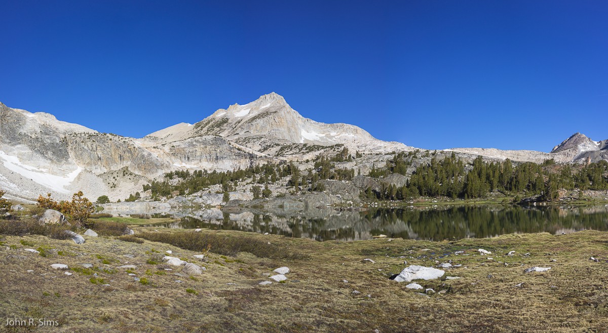 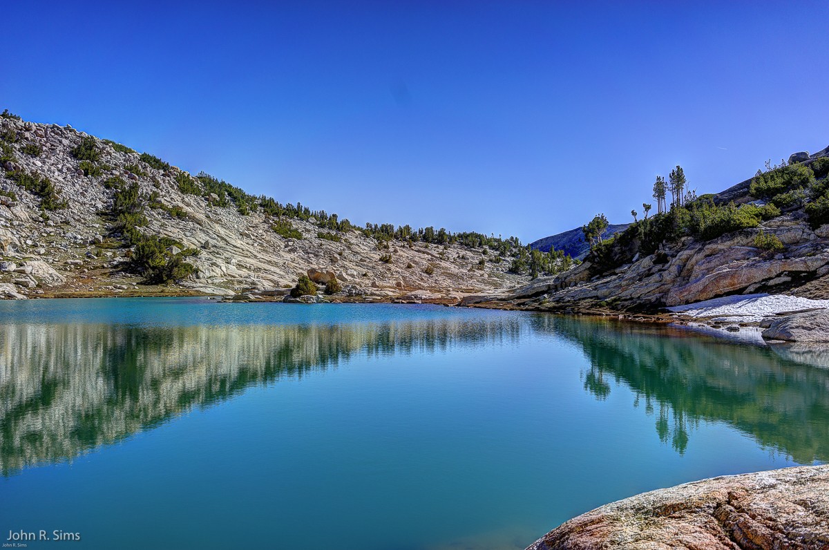 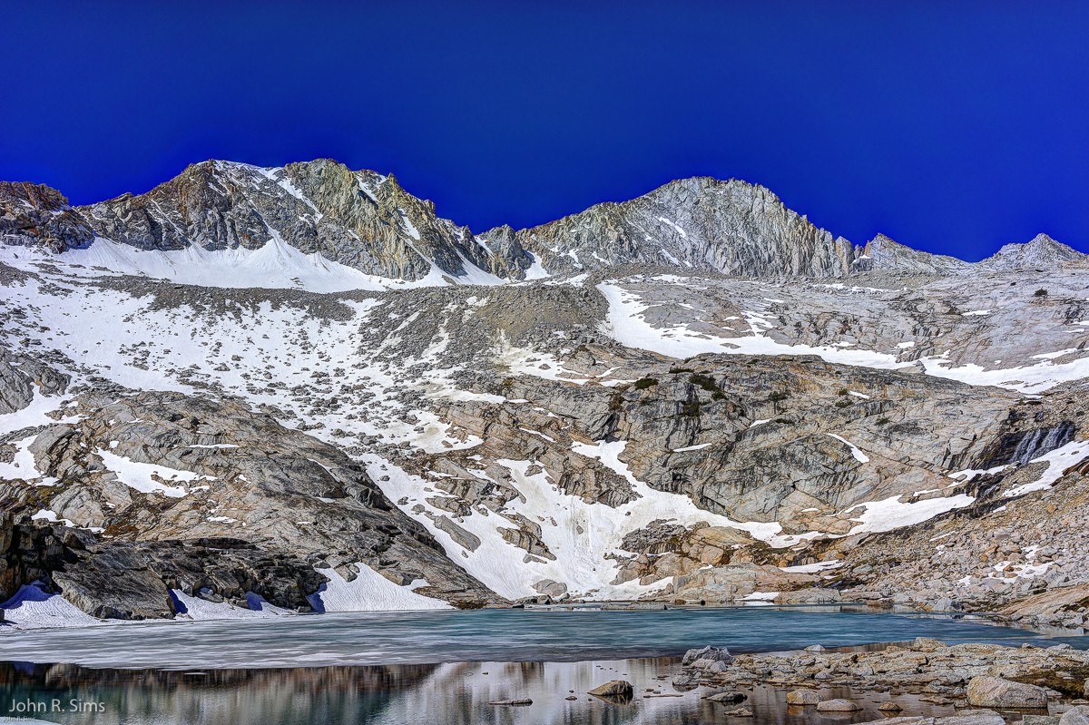 Day two was a short hike up to Crystal Lake. Four miles RT with perhaps 1,000’ of elevation gain. This is a well beaten path with lots of company – until you reach the far end of the lake. Working my way down to the beach took a bit of trial and error. Three pictures of the lake, all taken from the far end. 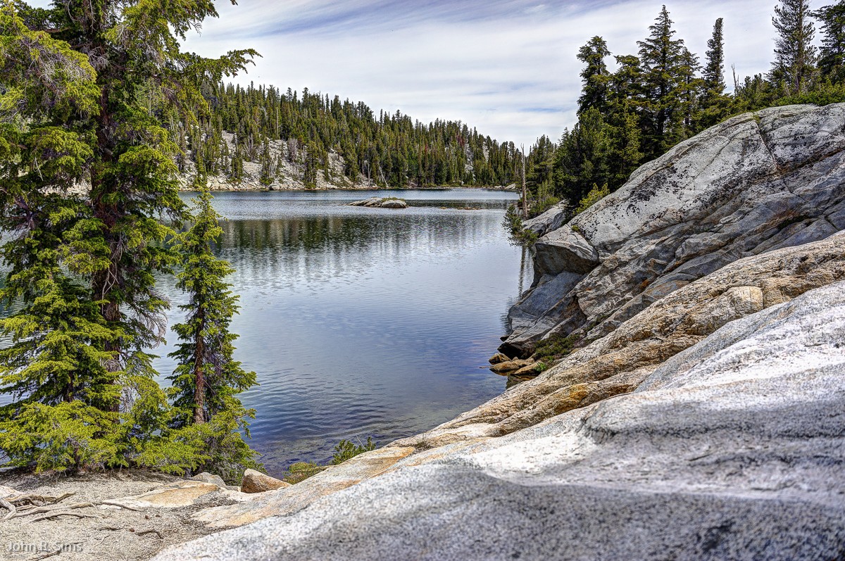 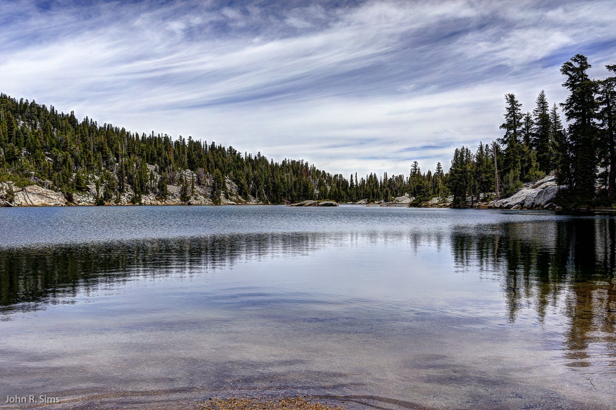  Day three was my longest hike. Agnew Meadows to Garnet Lake and back. Approx. 17.5 miles (RT), with ~2,000’ of elevation gain. Met two fellows doing the PCT. One of them from Australia, the other a student from So Cal. The student had a GoPro strapped on and had over 3500 photos so far. He was picking up a medium format camera when he reached Tuolumne Meadows to document his Yosemite visit. Interesting guy. He was also considering doing the Tahoe Rim Trail while he was passing through. Only added 100+ miles, and he did not seem to be rushed. Also met several hikers doing the JMT. All interesting to talk with. First picture is of Shadow Lake, followed by a shot of Ritter and Banner, and finally a pic of Garnet Lake. 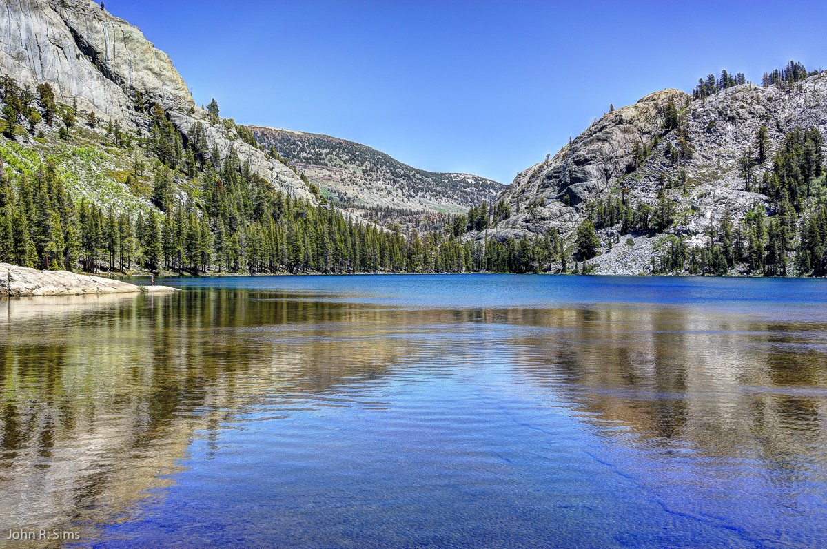 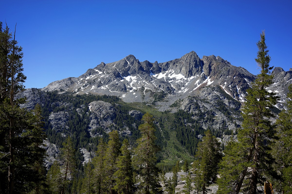 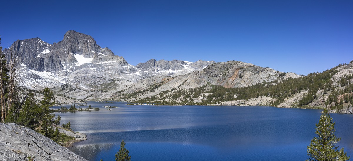
|
|
|
Re: Mammoth Lakes Training Hikes
|
Joined: Aug 2011
Posts: 464 Likes: 1
|
|
Joined: Aug 2011
Posts: 464 Likes: 1 |
I had asked months ago about Mammoth Lakes hikes not knowing exactly when I would be there. My hiking group has rented a 6 bedroom vacation home for 5 nights in mid August. Lake Ediza seems to be a favorite. I'm hoping there might be destinations along the way for some that don't care to hike that far. And Mammoth Mountain might be good. Can anyone tell me about the "Dragons Back" route? Maybe we could hike up that way and ride the tram down? Also thinking of a daytrip to the Ancient Bristlecone Pine Forest for some sightseeing and a short hike. I've read about a highly rated barbeque restaurant near the turn-off on 395. Anyone have any thoughts on this? I thought we might drive over and hike Cloud's rest but some in my group are going there next week right after we go up Mt Whitney MR. Those guys are retired, unfortunately I'll be going back to work from Whitney. And "Yay!" I fimally got backpack permits for the Grand Canyon 1st week in October. John, your pics are awesome, especially on this thread http://www.whitneyzone.com/wz/ubbthreads.php/topics/40519/Mammoth_Lakes_Hikes#Post40519. You, as many are on this forum, are an inspiration. BTY I'm going to find my way to Iceberg Lake next Thursday.
|
|
|
Re: Mammoth Lakes Training Hikes
|
Joined: Nov 2009
Posts: 1,256 Likes: 2
|
|
Joined: Nov 2009
Posts: 1,256 Likes: 2 |
Frank, Mt. Dana is a good one, as is Mono Pass. Both are short hikes, and Mt. Dana will get you to 13K' and back in half a day. We'll be out there in less than 3 weeks, sleeping 5 nights at Mammoth Lakes while dayhiking in Yosemite. Cathedral Peak and Cloud's Rest this time around. You can't beat sleeping in a Mammoth condo at 8K' with a blazing fireplace after a day of hiking in Yosemite. This will be our 3rd trip doing just that, staying in the same condo. After 5 nights in Mammoth, we'll shoot down to Lone Pine and plan to do the Whitney MR and Langley - weather, permits and legs allowing.
A quick side-trip in Yosemite is Olmstead Point. Huge parking lot and an overlook, with a granite dome behind it. Lots of people climb up this dome about half a mile for better views, but if you keep going you'll negotiate a small saddle to an even higher point. It may take some scouting to find your way up, but it's worth the effort. From this vantage you can see not only the valley to the west, but far back to the east including Tenaya Lake. I promise you'll be alone.
There are a couple of trails at the Ancient Bristlecone. We've hiked the Methuselah Trail, and it's well worth it. Short, but outstanding views and tons of Bristlecone pines. The drive up to the trailhead is fun too.
That BBQ restaurant you mentioned may be the Whoa Nellie Deli, an iconic eatery located in the Mobil station at 395 and Tioga Rd (120). Gourmet meals at a gas station - only in California. They have quite a menu that does include some BBQ, but also a variety of other items. The lobster taquitos are my favorite. Big green lawn with picnic tables overlooking Mono Lake, and often live entertainment. A must-experience if you've never been there.
|
|
|
Re: Mammoth Lakes Training Hikes
|
Joined: Apr 2012
Posts: 579 Likes: 3
|
|
OP
Joined: Apr 2012
Posts: 579 Likes: 3 |
Lake Ediza seems to be a favorite. I'm hoping there might be destinations along the way for some that don't care to hike that far.
Can anyone tell me about the "Dragons Back" route? Maybe we could hike up that way and ride the tram down?
I thought we might drive over and hike Cloud's rest but some in my group are going there next week right after we go up Mt Whitney MR.
Hey Frank and Bulldog, Lake Ediza is a popular destination. Two of the JMT hikers I spoke with were going there to camp, and it is not actually on the JMT. Just shows how popular it is. If you look on the map you will see another "Iceberg" Lake, ~ 1 mile south of Lake Ediza. I am told that this is well worth the added effort. My next trip I may try to get there from Reds Meadows, but the path may be difficult. I'll have to do more research. As for shorter hikes - Shadow Lake is ~ 4 miles from Agnew Meadows (en route to Lake Ediza), and is a worthy destination. In the picture below you can see boulders at the far end of the lake. Easy access from the trail, and great spots to kick back, have lunch, enjoy the sun, and for those so inclined perhaps a swim. 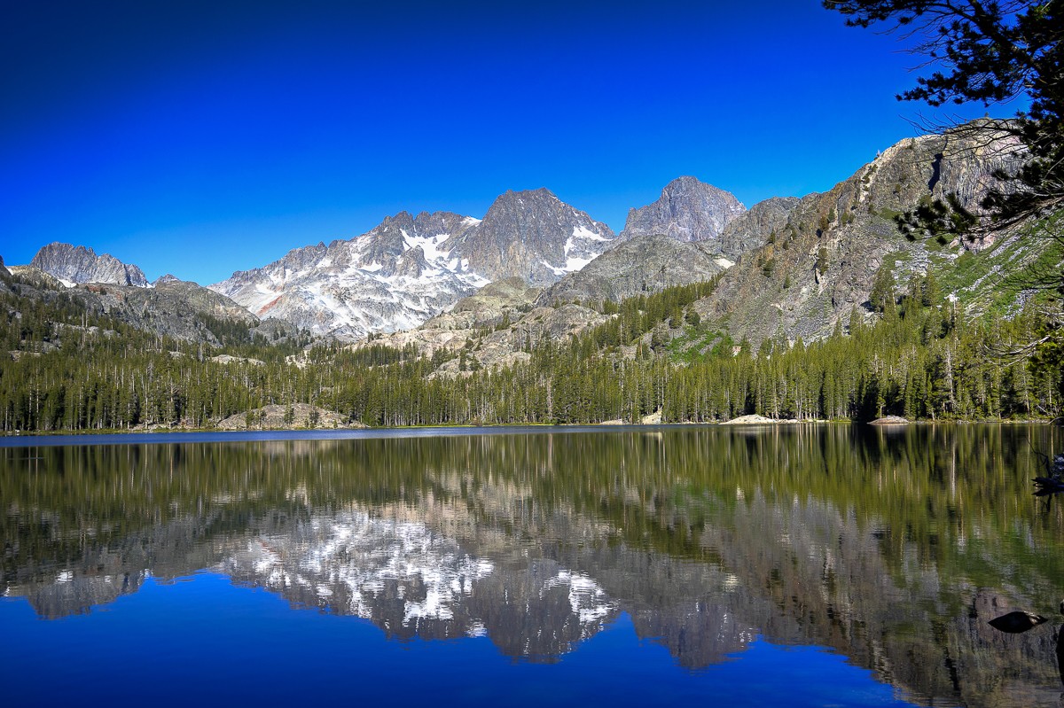 The dragons back is fairly steep, but a shorter route to the top compared to the trail starting at Mammoth Mountain Lodge. There are a few spots where you will need to trust your boots, but nothing exceptional. Also, no bicycles to deal with (although it can be fun to watch some of those guys flying down the hill). I "guess" you can buy a ticket at the top. Not really sure since I have not done that. Also, the trail head/tram start are far apart, so you would have to leave a car at the Tram station. Bulldog and Frank, we share a similar acclimatization process. I also enjoy the comfort of a condo while day-hiking the area as a comfortable way to adjust to the altitude. I'm sure you will enjoy your July and August visits. If you have not eaten there you should try Roberto's Mexican Cafe - 271 Old Mammoth Rd. Be forwarned, the servings are very large.
Last edited by John Sims; 06/21/15 11:02 AM.
|
|
|
Re: Mammoth Lakes Training Hikes
|
Joined: Aug 2011
Posts: 464 Likes: 1
|
|
Joined: Aug 2011
Posts: 464 Likes: 1 |
We'll be out there in less than 3 weeks, sleeping 5 nights at Mammoth Lakes while dayhiking in Yosemite... After 5 nights in Mammoth, we'll shoot down to Lone Pine and plan to do the Whitney MR and Langley - weather, permits and legs allowing.
I plan on camping at Upper Boyscout Lake July 14 & 15. We plan on summiting on the 15th. Any chance you'll be there?
|
|
|
Re: Mammoth Lakes Training Hikes
|
Joined: Nov 2009
Posts: 1,256 Likes: 2
|
|
Joined: Nov 2009
Posts: 1,256 Likes: 2 |
Yep. We arrive in Lone Pine the 14th and plan on heading up the North Fork the 15th, assuming we can obtain WZ day permits. We should definitely cross paths.
|
|
|
Re: Mammoth Lakes Training Hikes
|
Joined: Nov 2009
Posts: 1,256 Likes: 2
|
|
Joined: Nov 2009
Posts: 1,256 Likes: 2 |
Bulldog and Frank, we share a similar acclimatization process. I also enjoy the comfort of a condo while day-hiking the area as a comfortable way to adjust to the altitude. I'm sure you will enjoy your July and August visits. If you have not eaten there you should try Roberto's Mexican Cafe - 271 Old Mammoth Rd. Be forwarned, the servings are very large.
Thanks for the tip, John - we'll be there 5 nights so we'll give it a try. We typically eat in most nights in Mammoth, but my wife has developed an intense dislike for the Von's there. It's the only open grocery store in Mammoth during summer and the prices are similar to buying gas in Death Valley - captive audience strategy. It's almost as cost-efficient to eat out.
|
|
|
Re: Mammoth Lakes Training Hikes
|
Joined: Apr 2012
Posts: 579 Likes: 3
|
|
OP
Joined: Apr 2012
Posts: 579 Likes: 3 |
Thanks for the tip, John - we'll be there 5 nights so we'll give it a try. We typically eat in most nights in Mammoth, but my wife has developed an intense dislike for the Von's there. It's the only open grocery store in Mammoth during summer and the prices are similar to buying gas in Death Valley - captive audience strategy. It's almost as cost-efficient to eat out.
I fully understand your wife's point of view. I also find their selection weird. Often, I cannot find skim milk (perhaps I cannot see it for all the Almond Milk), but have a freezer dedicated to gluten free. You've probably already been there, but the turkey sandwiches at Schat's bakery are fabulous. They bake a turkey every day, and slice it as they make sandwiches. They offen many choices for bread. You have to get there close to noon, or it may all be gone.
|
|
|
Re: Mammoth Lakes Training Hikes
|
Joined: Nov 2009
Posts: 1,256 Likes: 2
|
|
Joined: Nov 2009
Posts: 1,256 Likes: 2 |
We've spent about a dozen nights in Mammoth over the last 5 years, but we've not gotten out to see the area much. Normally we're gone before dawn, to Yosemite, then back in the evening. The only places I know well are that damn Von's and Mammoth Mountaineering. Believe it or not, we've not even set foot in Devil's Postpile, and it's right there at Mammoth.
We'll change that this trip, since we only have 2 hikes or climbs scheduled during our 5 nights in Mammoth. That leaves a day to visit the Postpile and another to leisurely tour Yosemite Valley. It's been 10 years since we've been all the way to the Valley - too much cool stuff to do on the eastside!
|
|
|
Re: Mammoth Lakes Training Hikes
|
Joined: Aug 2011
Posts: 464 Likes: 1
|
|
Joined: Aug 2011
Posts: 464 Likes: 1 |
Lake Ediza is a popular destination....
As for shorter hikes - Shadow Lake is ~ 4 miles from Agnew Meadows (en route to Lake Ediza),
I've been researching the hike from Agnew Meadows to Shadow Lake and Ediza Lake. Do I need to study and take notes about the trail/route? Is the trail marked/signed? And I may try to drive to the trail head the day before so I know how to get there. I can drive there after 7pm, right? I plan on driving there the day of the hike before 7 AM. Is it more convenient to drive instead of taking a shuttle bus? What are the fees? If riding the shuttle is the cost per person? If driving, per vehicle? Several in my group have senior national park passes. Can we use these there?
|
|
|
Re: Mammoth Lakes Training Hikes
|
Joined: Apr 2012
Posts: 579 Likes: 3
|
|
OP
Joined: Apr 2012
Posts: 579 Likes: 3 |
I've been researching the hike from Agnew Meadows to Shadow Lake and Ediza Lake. Do I need to study and take notes about the trail/route? Is the trail marked/signed? And I may try to drive to the trail head the day before so I know how to get there. I can drive there after 7pm, right? I plan on driving there the day of the hike before 7 AM. Is it more convenient to drive instead of taking a shuttle bus? What are the fees? If riding the shuttle is the cost per person? If driving, per vehicle? Several in my group have senior national park passes. Can we use these there?
You have most likely already done this, but you will get lots of "hits" for internet search of "Shadow Lake Hike" or "Lake Ediza Hike". For instance: http://www.everytrail.com/view_trip.php?trip_id=1751750Also, map below highlights the trail junctions. They are all well marked, but if you missed one on the return you would end up at Reds Meadow. You would not be happy  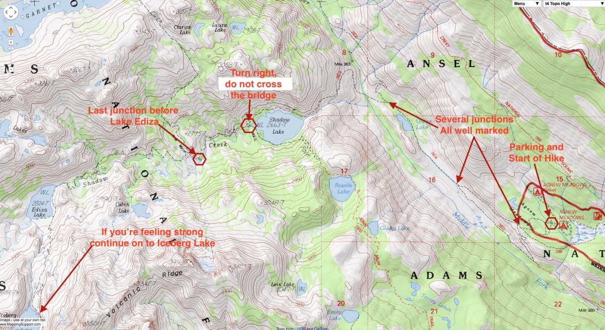 I'm not sure how punctual the rangers are at the gate, so you might want to wait until 7:30 PM to check out the trail head and parking. They do accept senior pass, so no cost in any case. Shuttle can be a pain. Adds 1/2 mile to the hike from road to trail head. Not a big deal, but at the end of the day you would prefer to avoid it. It also delays your start, and you may have to wait 30 minutes for return pickup. I think the fees are ~$7.00 each, but I'm not really sure.I would suggest going through the gate no later than 6:30 AM the day of the hike. Plenty of light at that time, so darkness is not an issue. Driving is more convenient, but the road is very narrow, and meeting another car (or the bus) can be tight. There are "wider" spots, so keep an eye out for traffic, and stop at one of these "wide" spots if you see another vehicle approaching.
|
|
|
Re: Mammoth Lakes Training Hikes
|
Joined: Jun 2010
Posts: 76 Likes: 10
|
|
Joined: Jun 2010
Posts: 76 Likes: 10 |
Frank, I went to Lake Ediza a little more than a month ago. Spectacular scenery. The entire trail is well signed and very easy to follow. There are a couple of intersections where it would be good to have looked at a map (or better, bring a map) to help you choose the right turn, but once you cross the San Joaquin River (which strangely drains into the San Joaquin Valley from the east side of the Sierra), you're basically hiking up into a canyon/drainage, so you keep going west. Don't carry more than a half bottle of water at a time; accessible water sources all along the way (bonus!). If anyone didn't want to go all the way to Lake Ediza (7 miles), any point would be a good turnaround. Shadow Lake is about four miles and also beautiful. At the time I went, I didn't realize that the shuttle didn't start running for about another week and I wasted 20 minutes trying to find an open ticket window or someone to ask. It's actually quite obvious (when open); you park on the right side of the road at Mammoth Main Lodge and the ticket window is right there, close to the road. It's $7/person. The NPS website says something about accepting passes, but isn't specific. That road to the trailhead is almost all one lane and there's some trailhead parking, but not a ton. I'd have no qualms about using the shuttle. My understanding is that it runs frequently, and I'm not aware of any real complaints about it. (Almost forgot to mention: when you get to Ediza, the log bridge to the main camping area at the northwest side of the lake has been broken by another log falling across it, making for a sketchy crossing. At least, it was to me carrying a 35 lb pack.)
|
|
|
Re: Mammoth Lakes Training Hikes
|
Joined: Aug 2011
Posts: 464 Likes: 1
|
|
Joined: Aug 2011
Posts: 464 Likes: 1 |
Some in my group are interested in renting canoes or kayaks and paddling at Twin or Lake Mary. Anyone have advice on this?
And I'm thinking stopping at the famous Whoa Nellie Deli for breakfast on the way to Yosemite to hike to Cathedral Lake. Which lake, Lower or Upper? Am I right that that's doable as a daytrip from Mammoth lakes?
|
|
|
Re: Mammoth Lakes Training Hikes
|
Joined: Oct 2009
Posts: 2,251 Likes: 1
|
|
Joined: Oct 2009
Posts: 2,251 Likes: 1 |
I can only help you on one of your questions: pizza.
Verum audaces non gerunt indusia alba. - Ipsi dixit MCMLXXII
|
|
|
Re: Mammoth Lakes Training Hikes
|
Joined: Sep 2009
Posts: 8,509 Likes: 103
|
|
Joined: Sep 2009
Posts: 8,509 Likes: 103 |
I think the Lower Cathedral lake is a nicer place to visit. It is definitely a nice day hike. It has a nice granite hump along the eastern side,and you can walk all the way around the lake, for some excellent picture-taking opportunities of Cathedral Peak. (IMO, one of the finest places in Yosemite.)
The JMT passes right beside the upper lake, but due to topography, hiking around isn't an easy task. It is a pretty place, and takes a bit more energy to climb up to it. Though for brisk hikers is also not a bad day hike.
|
|
|
Re: Mammoth Lakes Training Hikes
|
Joined: Aug 2011
Posts: 464 Likes: 1
|
|
Joined: Aug 2011
Posts: 464 Likes: 1 |
Thanks all for the info.
Since some in my group want to paddle in a lake we'll probably go to Twin or Lake Mary and rent a canoe , kayak, or paddle boats. Can anyone recommend a half day hike near these lakes. I don't think we'll be paddling all day.
|
|
|
Re: Mammoth Lakes Training Hikes
|
Joined: Nov 2009
Posts: 1,037 Likes: 6
|
|
Joined: Nov 2009
Posts: 1,037 Likes: 6 |
great nearby hike is this:
from Twin Lakes drive up to Lake George. Take the trail toward Crystal Lake that is nice, but even better is turning right at the junction and going all the way up to the crest. You start in the trees, climb above blue Lake George (to the junction), continue on eventually to red volcanic scree, then top out with a great view of the Minarets, Banner, Ritter.
This is one of our favorite warm-up/acclimatization hikes in the area. I think maybe 4 hrs round trip.( edit 6 miles round trip. gets you up to 10,600)
Last edited by Harvey Lankford; 07/14/15 08:20 AM.
|
|
|
Re: Mammoth Lakes Training Hikes
|
Joined: Aug 2011
Posts: 581 Likes: 10
|
|
Joined: Aug 2011
Posts: 581 Likes: 10 |
|
|
|
Re: Mammoth Lakes Training Hikes
|
Joined: Aug 2011
Posts: 464 Likes: 1
|
|
Joined: Aug 2011
Posts: 464 Likes: 1 |
great nearby hike is this:
from Twin Lakes drive up to Lake George. Take the trail toward Crystal Lake that is nice, but even better is turning right at the junction and going all the way up to the crest. You start in the trees, climb above blue Lake George (to the junction), continue on eventually to red volcanic scree, then top out with a great view of the Minarets, Banner, Ritter.
This is one of our favorite warm-up/acclimatization hikes in the area. I think maybe 4 hrs round trip.( edit 6 miles round trip. gets you up to 10,600)
Thanks, Harvey. I think this is the hike I liked best when researching hikes in the area near the lakes for boating. Do I make it to Crystal Lake? I do want to go to Mammoth Crest. I'll find out where the trail head is and the route. It seems the right length so we can hike in the morning, have lunch, and paddle in the afternoon.
|
|
|
Re: Mammoth Lakes Training Hikes
|
Joined: Nov 2009
Posts: 1,037 Likes: 6
|
|
Joined: Nov 2009
Posts: 1,037 Likes: 6 |
time and distance I quoted is for the Lake George to Crest and back route. Crystal Lake would be shorter, Deer Lake would be longer. Whole circuit even longer - see below. Mammoth Crest this link shows the whole route of the Mammoth Crest. On the trail profile shown, which I have done from right (Coldwater Cr/Duck Pass end) to Deer Lakes to the left (Lake George), is a long wonderful hike. The shorter acclimatization hike you want would be from left ( Lake George) toward the right. You can see that the junction to Crystal Lake is only 2 miles or so, one way. Turning left to the lake and downhill some, gets you to Crsytal Lake with views of the lake, Crystal Crag, and the Mammoth Crest. Turning right at the junction gets you near the top of the actual crest to an area of red volcanic scree, a very colorful scene. Once at the top, the views really open up. A morning start is best for coolness, and sun on the east facing Minarets rather than in your eyes. Picture of Deer Lakes is in this link. You would not go this far. Mammoth Lakes Trail System in that same link, there is a map without much labeling, but the trail starts on the left at unlabeled Lake George ( above labeled Lake Mary), then ascends to the junction and short spur trail turning left (actually you would go more or less straight) to unlabeled Crystal Lake, or at the junction turning right to unlabeled Mammoth Crest. I have had friends blow right by the junction and miss the turn somehow. Mammoth Crest Trail map
Last edited by Harvey Lankford; 07/15/15 04:49 AM.
|
|
|
|
|


