Mt Whitney Zone
Posted By: postholer.com Free JMT Trail Maps and Data Book - 12/01/10 05:38 PM
The new JMT map set is here!

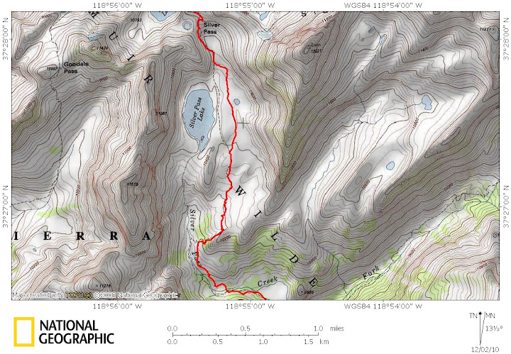
You can view the data book and the entire 41 image map set online or registered postholer.com hikers can download both together in the PDF file.

You can also view the google JMT map which has the same way points and trail trace as the above maps.

Features:
+ 41 full color maps created from 7.5 minute USGS quads
+ Beautiful 3D hill shading
+ Highly detailed elevation chart on each map
+ Large 8.5" x 11" maps for easy viewing
+ Accumulated trail mileage/elevation every half mile
+ Resupply locations within 90 miles of map center
+ WGS84 decimal degree tick marks for easy GPS use
+ Data book information printed at each locale on the maps
+ Separate data book appendix
+ Over 135 way points and resupply locations

The hiking community consists of folks with a wide range of talents and skills. When one of us can contribute our skills to the benefit of the hiking community without muddling things with financial renumeration, it's always a good thing. YMMV.

-postholer
Posted By: Steve C Re: Free JMT Trail Maps and Data Book - 12/01/10 10:09 PM
Very NICE data compilation. Thanks for posting the link here.

One thing I noticed: The Data Book shows the Whitney high point as 14,476 ft. (That may be a typo from the old high of 14,496)

Most places now put the summit at 14,505.
Posted By: postholer.com Re: Free JMT Trail Maps and Data Book - 12/02/10 12:24 AM
Originally Posted By: Steve C
One thing I noticed: The Data Book shows the Whitney high point as 14,476 ft.....Most places now put the summit at 14,505.


The elevation data comes from USGS and is probably collected with radar. Further, the lat/lon point may not be exactly, down to the foot, at the top of Whitney. So there is some wiggle room in terms of exactness.

If you're 29 vertical feet away from the top, you'll probably find it easy enough! (or you're in free fall and it won't matter anyway) wink

-postholer
Posted By: bill-e-g Re: Free JMT Trail Maps and Data Book - 12/02/10 03:55 AM
Nice maps...

You probably want to correct the Northern Terminus in Yosemite
as it is traced incorrectly though.
The trail starts on the eastern side of the Merced and then
crosses over it at the Vernal Falls Bridge.
Probably people would be slightly irritated to find out later
that they missed the big John Muir Trail sign to start
their long trek ..
Posted By: postholer.com Re: Free JMT Trail Maps and Data Book - 12/02/10 05:30 AM
Originally Posted By: bill-e-g
The trail starts on the eastern side of the Merced and then crosses over it at the Vernal Falls Bridge. Probably people would be slightly irritated to find out later
that they missed the big John Muir Trail sign to start their long trek ..


You mean I missed the big JMT sign?

Fortunately, I didn't get lost and run out of food in one of the Yosemite valley parking lots. wink

I'll look into that and see about correcting it.
Posted By: bill-e-g Re: Free JMT Trail Maps and Data Book - 12/02/10 01:33 PM
You traced the horse trail.

If I was being "really" picky I would have told you
that it's also off by Silver Pass Lake.
wink
Posted By: Fishmonger Re: Free JMT Trail Maps and Data Book - 12/02/10 01:55 PM
GPS track from our 2010 yoyo - came down on the JMT, returned on Mist trail, where the GPS lost a few points, but you can still see where the turnaround point is - we took a photo right at the big sign and went back up.


link to full screen. in case I forgot how to do html in this forum (it doesn't work in the preview mode)

http://www.mappingsupport.com/p/gmap4.php?q=http://didnt.doit.wisc.edu/outdoor/muir2009/gps/2010/filtered/20100710.gpx&t=t2
Posted By: Steve C Re: Free JMT Trail Maps and Data Book - 12/02/10 02:43 PM
Originally Posted By: bill-e-g
If I was being "really" picky I would have told you that it's also off by Silver Pass Lake.
wink

Bill, what part is "off"? I looked at the map an it seems ok to me.
Posted By: bill-e-g Re: Free JMT Trail Maps and Data Book - 12/02/10 03:13 PM
Originally Posted By: Steve C

Bill, what part is "off"? I looked at the map an it seems ok to me.


It's just one of those deals where they rerouted the trail a bit to get it away from a sensitive area or make the ford a little safer.
It looks more like this:


Of course this is nit-picking. It's pretty darn hard to lose the JMT IMO.
This area was one of our favorites on the entire trail.
Posted By: Steve C Re: Free JMT Trail Maps and Data Book - 12/02/10 03:16 PM
Oh, ok. Thanks. I hiked over Silver Pass this past summer, and now that you point it out, I do recall being quite some distance from the lake.
Posted By: bill-e-g Re: Free JMT Trail Maps and Data Book - 12/02/10 03:20 PM
Um... while I'm at it I can tell you that it's not
correct at Evolution Lake either. That's another
area where they really moved the trail to get it
away from the lake.

Annoyed yet?

Looks like this:


Made it a point to hike the old trail the next time I
was thru that area. (stepping gingerly...)
Posted By: Steve C Re: Free JMT Trail Maps and Data Book - 12/02/10 03:29 PM
No annoyance here smile

But I am wondering if Postholer Scott is interested in applying these suggested changes to his maps.
Posted By: postholer.com Re: Free JMT Trail Maps and Data Book - 12/02/10 03:35 PM
Originally Posted By: bill-e-g
Um... while I'm at it I can tell you that it's not correct at Evolution Lake either. That's another
area where they really moved the trail to get it
away from the lake. Annoyed yet?


Annoyed? Heck, you're gonna have to do better than that!

It's all good info.

With trails such as the PCT you'll often find 2 routes, one is a stock route and one is a hiker route. Many times the stock route is the "official" route. I suspect that may be the case with the Mist Trail, though I'm not sure.

Like Silver Lake, you'll probably find a few spots have been rerouted for the purpose of rehabilitation.

Thanks for the feedback!
Posted By: postholer.com Re: Free JMT Trail Maps and Data Book - 12/02/10 03:40 PM
Originally Posted By: Steve C
But I am wondering if Scott is interested in applying these suggested changes to his maps.


Definitely!

If I had the lat/lon's in any format for the segments in question, I'll definitely update sooner rather than later.

The map creation process is automated and the entire map set can be generated in a couple hours.
Posted By: Fishmonger Re: Free JMT Trail Maps and Data Book - 12/02/10 04:52 PM
Originally Posted By: postholer.com

With trails such as the PCT you'll often find 2 routes, one is a stock route and one is a hiker route. Many times the stock route is the "official" route. I suspect that may be the case with the Mist Trail, though I'm not sure.

Like Silver Lake, you'll probably find a few spots have been rerouted for the purpose of rehabilitation.


Mist trail is not part of the JMT, but below the bridge the JMT runs on the north side of the river. Above the bridge, the JMT follows the horse trail to the top of the falls (and more asphalt!). Mist trail is something a lot of people choose as an alternative, because it has some highlights worth the steep steps, but I bet many southbound Day 1 hikers still choose the regular route for its easier grade.

Evolution Lake has been re-routed quite a few years ago and nobody does take the old route any longer. The Silver Lake route also has been east of the lake for well over a decade. In fact, I think even in 1988 on my first trip, we were east of the lake.

Two summers ago they re-routed a part of the Forester Pass north ramp at the highest meadow, but only for about a quarter mile.

Looking at a few of my GPS tracks, I can see deviation from the USGS map route very frequently, and none of those deviations are reception errors. The trail has either been re-routed in a lot of areas since teh USGS maps were made, or, more likely, the map makers were sloppy. Just look at the track below - other than the ridge detour skipping final switchbacks north of Forester Pass where there was just a ton of snow, we were right on the trail all day. I'd say 30% of the map for that day between our camp north of Forester and Guitar lake is wrong. I know from the terrain features on the map that the GPS track very much represents where we hiked.

Forester to Guitar Lake

Posted By: postholer.com Re: Free JMT Trail Maps and Data Book - 12/02/10 05:11 PM
Originally Posted By: Fishmonger
I'd say 30% of the map for that day between our camp north of Forester and Guitar lake is wrong. I know from the terrain features on the map that the GPS track very much represents where we hiked


Very interesting. They do differ quite a bit.

Fortunately, It's not to the degree that anyone is going to be walking around lost, particularly in complete snow coverage where 'the trail' is just an idea anyway. On clear trail it won't be an issue.

As time progresses, I'll continue to update the data. I have other data sources I'll look into.
Posted By: bill-e-g Re: Free JMT Trail Maps and Data Book - 12/02/10 05:29 PM
Yeah, I really just wanted to point out the start of the trail
was pretty erroneous. They are continually "improving" the
trail for various reasons.
The rest is pretty much no biggie... but I'm gonna lookie
at Foerster when I get home tonight...
Posted By: bill-e-g Re: Free JMT Trail Maps and Data Book - 12/03/10 01:23 PM
Yup. Remember it now. Just north of Crabtree it's way off
the original route.
And now I remember that it was way off south of Pinchot
also. And ... just south of Devils Postpile where the big
burn occurred...
I can post some maps of these areas if you really want...
If you want GPS tracks can do that ...
The 2007 Tom Harrison JMT Map-Pack have all the areas
except Devils routed correctly.

I can't think of any horse/hiker differing sections on
the JMT. In Yose the only horse trails are from
Happy Isles to the JMT connection above the Vernal Falls
Bridge comfort station and a maybe you could call the
connector trail from the stables in TM to Glen Aulin trail.
Seen some horse poo this way/hiker that-a-way in Emigrant.

Have a nice day
Posted By: postholer.com Re: Free JMT Trail Maps and Data Book - 12/03/10 02:58 PM
Thanks for the info Bill!

Anything I can do to improve the accuracy, I will.

I've gotten my hands on tons of new gps data and have seen several discrepancies. If you have any data you would like to share, I'll be glad to take it off your hands.

You can send me a link to it if it's on the web somewhere, or just email it to public@postholer.com

Thanks!
-postholer
Posted By: Fishmonger Re: Free JMT Trail Maps and Data Book - 12/03/10 04:48 PM
I have GPS tracks for most of the trail from 2008, 2009 and 2010. the only JMT areas not covered by our tracks are the JMT from Reds Meadows to below Silver Pass (we never go that route) and the 2 miles to Whitney summit - didn't have the weather the lat few times we got there to justify the detour.

here are all our2010 tracks already mapped - and the the orignal GPX files on my server

Our 2009 route is on google maps. All gpx files used there are here.

the 2008 files are very similar and include all of Bear Ridge, but that stuff is correct in your maps so no need.
Posted By: postholer.com Re: Free JMT Trail Maps and Data Book - 12/03/10 05:28 PM
Originally Posted By: Fishmonger
I have GPS tracks for most of the trail from 2008, 2009 and 2010.....


Well now.

This is a gold mine of data. Thank you *very much* for making this available.

In the next week or so I'll use it in combination with the other sources I have to make the most accurate trace I can.

Everyone interested in free/accurate JMT maps and data book will benefit from your contribution.

That was a huge help, thanks again!
-postholer
Posted By: bill-e-g Re: Free JMT Trail Maps and Data Book - 12/03/10 05:55 PM
I'll email you mine soon... do with it as you please.
There's gotta be a huge amount of data out there.
A ridonkulous number do the John Manure Trail every year.
Posted By: postholer.com Re: Free JMT Trail Maps and Data Book - 12/08/10 11:23 PM
The postholer JMT maps have been updated with the new data generously provided by Mr. Fishmonger and Bill!

Further, I've created a northbound *and* southbound set with matching data book appendices. You can view the northbound set online and download either from that page.

Thanks again folks for your data, I know the whole community appreciates it!

-postholer
Posted By: bill-e-g Re: Free JMT Trail Maps and Data Book - 12/09/10 01:09 AM
It's still a little bit off just S. of Devils Postpile
where the big burn occurred. Perhaps you missed
that (I mentioned it above) b/c fishguy didn't jump onto
the JMT until around Chief Lake instead going up Fish Valley.

Nitpicking, yeah...
Do with it as you wish.

Thanks for the maps
Posted By: postholer.com Re: Free JMT Trail Maps and Data Book - 12/09/10 02:43 PM
Originally Posted By: bill-e-g

Nitpicking, yeah...


Yeah, you nitpicker! eek

Fishmonger also pointed out 2 other spots that are off a tad. Very minor stuff, though. None of it misleading.

The scale and detail of these maps show every turn in the trail. If these maps were the same scale as other maps, you would probably never notice.

This set will live for awhile until I collect more way points and such.

Thanks again Bill for your data!
-postholer
© WhitneyZone Message Board