Mt Whitney Zone
Posted By: Bulldog34 Wildrose Peak - 02/13/11 04:27 PM
Anyone been up the Wildrose Peak trail in Death Valley recently? I'm curious what the snow/ice conditions are and if it's easily do-able in micro-spikes (or actually, will be in about 3 weeks). I tried the backcountry DV rangers but can't seem to locate anyone there that has a clue what conditions are like on this particular trail.

I know Telescope Peak was a snowshoe walk a couple of weeks ago, according to SierraGator Jim. Wildrose is a couple of thousand feet lower (9K'), so I would think that by the first week of March it would be easily do-able in micro-spikes at the most? Any beta would be appreciated.
Posted By: KevinR Re: Wildrose Peak - 02/13/11 06:06 PM
Right now Wildrose has early spring conditions. A friend did it a couple of weeks - the day after we'd done Corkscrew - and reported no snow at the kilns, and only scattered patches in the sheltered drainage leading to the ridge. However ... the past several weeks have been unusually mild, and that appears to change soon. This is a good site to get more info on the impending weather.

I'd re-post that question a bit closer to your trip. Wildrose and Fall Canyon are on my short list of mid-week hikes over the next few weeks. Mainly waiting for the wildflowers to hit their stride in DV before doing them.

Ever consider doing Surprise Canyon/Panamint City, just north of Ballarat?
Posted By: Steve C Re: Wildrose Peak - 02/14/11 04:29 AM
Thanks for the info, Kevin. Just for general info, your link to Mammoth Lakes Weather is included on the Mt Whitney Weather page (in the Feature Topics box on the left).
Posted By: Bulldog34 Re: Wildrose Peak - 02/14/11 11:21 AM
Thanks Kevin - good info. We'll see what happens with the weather - I'll bring the spikes and hope that any snow isn't too deep. I did this once in late summer a few years back, and from what I can recall it was a pretty easy stroll up until the last mile or so. Good weather link, too.

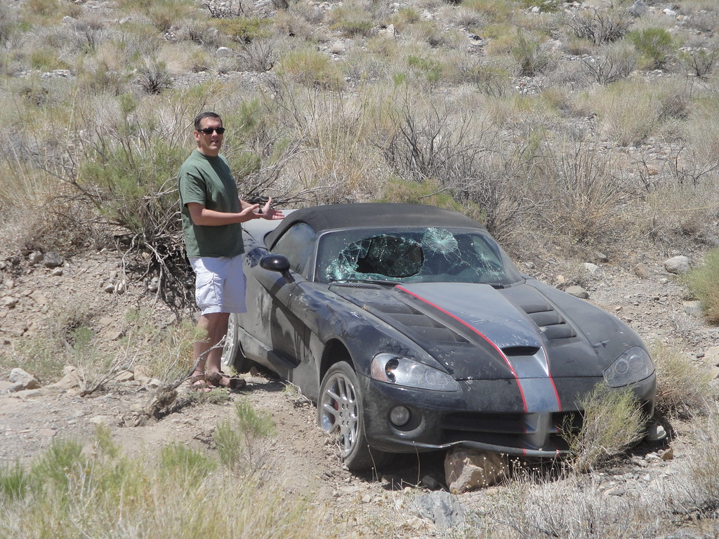
The road to the kilns is one of my favotite "fun" drives in California (CA 168 to White Mountain is # 1). Last summer on the way to the Sierra I detoured and took my family up and down that road for the first time (my wife hates roads like that but my daughter is a coaster junkie, so she loved it). On our way up we were passed at a pretty good clip by a group of 6 Vettes on their way down (they clearly knew a "good" road too). On our way back down, we ran into this on the side of the road:


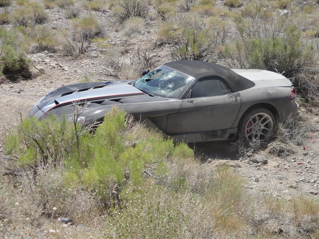
From the skid marks on the road, the dude lost it coming out of a turn and spun into the rocks on the side of the road. His Vette buddies clearly took him away and there was no blood in the interior, so he must have been alright. I've wondered since how he explained that to his insurer . . .

Surprise Canyon is one I've always wanted to do, but the length of the hike and the distance from my usual camp at Texas Spring has always had it on the back burner. Same story with Titus Canyon to Leadfield (ville?). I'd really like to hit a ghost town this year on a hike, so one of these two will probably make the itinerary. So far John and I have landed on Corkscrew, Wildrose, DV Buttes and Monarch Canyon, as well as the obligatory ramble around the Badwater Basin when it's comfortable and not hell on earth. Other hikes we're considering are the Albatross crash site, Little Bridge Canyon, Sheep Canyon, Willow Canyon, Darwin Falls and Virgin Springs Canyon. Any other recommendations are welcome.

Since I'm usually doing 5-7 consecutive days of hiking on these trips, the trick is ensuring I don't put two strenuous hikes back-to-back. I'm playing with the idea of camping at Stovepipe Wells this year to cut down on the daily driving, but I've never pulled into that campground or checked out the Stovepipe Wells General Store. I've definitely enjoyed having the Furnace Creek General Store near Texas Spring. When we hit the park in a couple of weeks we'll probably check it out before we automatically set up in the Furnace Creek area.
Posted By: Fishmonger Re: Wildrose Peak - 02/14/11 01:03 PM
that's a Viper - the insurance agent already knows why he'll be calling. whistle

http://www.forbes.com/2010/08/19/car-aut...ve_slide_9.html
Posted By: Bulldog34 Re: Wildrose Peak - 02/14/11 01:11 PM
Make that mostly Vettes - they went by pretty darn quick. Eighty grand gone in a flash!

Side view:

Posted By: Fishmonger Re: Wildrose Peak - 02/14/11 01:30 PM
Originally Posted By: Bulldog34
Eighty grand gone in a flash!


ah, that'll buff out in no time
Posted By: KevinR Re: Wildrose Peak - 02/14/11 02:04 PM
That road between the Kilns and the junction can be tricky. On the last trip up Telescope last fall a car of young people were headed uphill way too fast and nearly nearly front-ended us on one of those dipsy-do curves.

If/when you do Panamint City - it's easy grades of about 3,400' over 5.5 miles. There's a section of narrow, marble canyon in the first 1.5 miles which is wet/slippery in places, and sometimes I just wear some heavy leathers and use the brook for footing. Nothing tricky, just use care. There's a steep, narrow canyon on the left (north) as the top of the last cascade - sometimes bighorns can be see using it as an access path. There are some ancient grasses in this brook also - horse something or other, I think. It's thick, woody and resembles minuiature bamboo.

Panamint City was the site of an active mine about 135 years ago. About .5 miles from the main mining area you can see the old brick smokestack, and then foundations of old structures. There are some newer buildings/structures built in the 1970's, and the main office is in good repair and was fairly clean as of last week. You wouldn't need a tent to overnight there, and there are other buildings as well. There's potable water from a freeze-proof faucet on the left side of large structure housing the abandoned generator. Apparently a Canadian company sunk some $$$ into operations back in the '70's, but the market fell (some say it was manipulation) and the storms caused serious damage to the road and it was never rebuilt. The TH is on BLM land, and somewhere along the way it crosses into the NP. Keep your eye out for snakes, but it's pretty early up high. The ground was frozen above the last cascade. Because of two major springs, much of the canyon - especially in the first 3 miles - has reverted to dense vegetation.

The burros seem to be out of the canyons and in the valley, so keep an eye out if you're driving at night in Panamint Valley.
Posted By: KevinR Re: Wildrose Peak - 02/14/11 02:51 PM
Originally Posted By: Steve C
Thanks for the info, Kevin. Just for general info, your link to Mammoth Lakes Weather is included on the Mt Whitney Weather page (in the Feature Topics box on the left).
Thanks, Steve. Didn't know Schecter's site was there as I never have any luck getting your weather page to load.
Posted By: Steve C Re: Wildrose Peak - 02/14/11 03:10 PM
Originally Posted By: KevinR
Thanks, Steve. Didn't know Schecter's site was there as I never have any luck getting your weather page to load.


Anybody else have trouble seeing the weather page?   Mt Whitney Weather
Posted By: Fishmonger Re: Wildrose Peak - 02/14/11 03:16 PM
Originally Posted By: Steve C
Anybody else have trouble seeing the weather page?   Mt Whitney Weather


works for me. Snow coming in tomorrow.

http://forecast.weather.gov/MapClick.php...nit=0&lg=en
Posted By: KevinR Re: Wildrose Peak - 02/14/11 03:31 PM
Might be the browser. Firefox works fine, Chrome does not. Favor Chrome because it stores bookmarks and seems faster overall.
Posted By: Bulldog34 Re: Wildrose Peak - 02/14/11 03:45 PM
Originally Posted By: Fishmonger
ah, that'll buff out in no time


The undercarraige won't . . . smile
Posted By: KevinR Re: Wildrose Peak - 02/24/11 05:04 PM
Did Wildrose yesterday with some friends. A bit of snow, but the trail sees enough traffic to keep it packed. Didn't need snowshoes nor microspikes. There's a storm predicted over the next few days with some unusually cold temps, so that could change conditions. Noticed a few hardy souls camping near the intersection, and there was a trailer and US flag flying on the pole near the old NPS building. First time I've seen any activity there in years.

Saw a couple of wild burros near the turn for Ballarat in Panamint Valley.
Posted By: Bulldog34 Re: Wildrose Peak - 02/24/11 10:12 PM
As usual Kevin, you're a treasure trove of beta. Conditions up there have been on my mind since the storm this past week. We have Wildrose on our itinerary a week from today, but I'll only be equipped with micro-spikes and desert gaiters - I've been concerned about whether it would be do-able with just those in lightweight hikers, which are my only current pair of boots. And it's too late to get a sturdier, water-resistant pair that I won't have a chance to break in. Guess we'll have to see what this next storm does. Corkscrew Peak is our plan for next Saturday, and I'm also concerned about what the conditions will be like there. Our itinerary may change . . .

How was the Wildrose road? The DV Morning Report says it's icy past the pavement on up to the kilns.
Posted By: catpappy Re: Wildrose Peak - 02/24/11 11:02 PM
Gary, if need be, you could use my one year old, broken in Asolo's size 11. I've got an ancient pair of Raichle's that would do for this trip.

John
Posted By: KevinR Re: Wildrose Peak - 02/25/11 01:27 PM
Gary -

Re: the road - down near the intersection (near the old NPS headquarters) there was a icy road warning sign, but the slippery road didn't start until about 1/4 mile below the kilns. You could avoid it by driving on the far left as that edge of the road had melted somewhat. That was in the AM - when we left around 1:30PM, it has mostly melted. However, a storm is working its way south and east, so more snow in the next couple of days is likely, so conditions change. Still - if you find it too icy/snowy for the rental car, drive as far as comfortable, and hoof it the rest of the way. Below the kilns, the road is quite open to sunlight, and melts rapidly (above is quite shaded, so it's a different issue, but it's gated, so doesn't matter anyway).

As for warm boots - personally, I wouldn't do Wildrose in light hikers as there will be snow underfoot, even if the current storm misses DV entirely. The kilns are at 6,900' and the summit is 9,000', so the ground is frozen and trail snow-covered nearly the entire distance. I can recommend two boots, both from Cabela's - one is the Avalanche and the other is the Snowrunner. These boots are quite warm and require no break-in. Don't know which airport you're using (probably Vegas) but if it's Reno there's a Cabela's on I80 west heading towards Donner Pass. Corkscrew isn't as tall, so snow is less of an issue. The only place I've seen it is the last quarter mile below the summit as it's shaded, so your light hikers would probably be OK. And of course - if Catnappy's boots fit you're fine.

I grew up in a cold climate and was outdoors frequently, so have deep-chilled my feet many times, including frostbite twice, so ... they're cold-sensitive and as I get a bit older realize that damage has impaired the circulation, particularly in my right foot. So, I don't fool around.

With snow on the ground, everything changes. The likelihood of anything adverse happening is rather small, but when I hike I try to be to be prepared for the "what if's" - what if I needed to spend the night? At 8 or 9,000', even in Death Valley, it gets pretty cold at night.

I particularly like Cabela's Avalanche boot. With those, you could hike any peak in the Northeast, even Mt Washington or Mt Marcy, in winter. They work well with snowshoes and strap-on crampons. There are lots of good snow boots in the $100 range as well - am just more familiar with those than others.
Posted By: bobpickering Re: Wildrose Peak - 02/25/11 06:14 PM
I could be wrong, but I don't think I would hike Wildrose right now with anything less than these boots and a pair of Gore-Tex gaiters. 9,000' in Death Valley certainly has less snow than 9,000' around Reno/Tahoe, but we got a lot of snow last weekend. At least a couple of feet up high. We got about 8" at my house (at 5,000') with another 5" in the last 12 hours. We're expecting more in the next day or two, followed by some melting and settling.

Assuming the roads are OK, I plan to drive down (~350 miles each way) to meet Gary and others for Corkscrew Peak (5,804') on 3-5. I'll bring the Asolo boots and something lighter and make a final boot decision when I see the conditions. I would rather look like a fool for being over-prepared than freeze my toes and/or have to turn back because I only brought trail runners.
Posted By: KevinR Re: Wildrose Peak - 02/26/11 01:09 PM
While the storm hit hard further north with lots of snow (Mammoth got buried), aside from 2 days of high winds and occasional showers, it didn't amount to much precip-wise further south. Snow level here in the Indian Wells Valley is around 4K', and looking at the webcam, it looks about the same in the Owens Valley around Lone Pine. Looks like a mostly sunny day despite the forecast.
Posted By: Bulldog34 Re: Wildrose Peak - 02/26/11 04:55 PM
Kevin, that's good news - reading the DV Morning Reports the last few days, they're calling for snow levels to drop to 2000 feet by tomorrow afternoon, so I was really getting concerned - mainly about the Wildrose road as much as anything else.

I'm going to run out to Dick's or REI this afternoon and try on some waterproof boots. I'll go ahead and buy if I find a pair that feels like minimal/no break-in. I won't use them much, but for situations like this they'll be nice to have when confronted with deeper-than-expected snow. I've never run into anything that my Merrell Moabs couldn't handle, but they haven't been in snow deeper than 3-4 inches, and then only for relatively short stretches. They're really "breathable", which means they soak pretty easily in soppy conditions - though they dry quickly. I've used these Moabs for 6 years now, and am on my 3rd pair (about 700 miles each on the first two sets). Time to expand my horizons.

Again, Kevin, I appreciate all the advice and info you've supplied! Catpappy and I will be camped at Texas Spring Wednesday through Tuesday morning. If you're in the area, drop by and have a brew (or climb something with us). I'm easy to spot - I'll be the guy in the red UGA ballcap. The dweeb in the piss-yellow Georgia Tech cap would be Catpappy. If you chance on us after Saturday, we'll be the two guys looking exhausted after Mr. Pickering kicks our butts up and down Corkscrew . . .
Posted By: KevinR Re: Wildrose Peak - 02/26/11 08:28 PM
Gary - I can see the Panamints from my place (about 50 miles away) and it looks like the snow level and amount of snow of snow is lower (and more) than on this eastern end of the Sierra, so some warm boots are a good idea.

Thanks for the invite. I arrange hikes for a "Wednesday Group", and this week will be up on Malpais Mesa via the Santa Rosa mine route, which is near the western edge of DV, off the Saline Valley Road west of Father Crowley's. The mesa overlooks Owens Lake. There's evidence that native peoples spent much time up there, and our group's conjecture is it would be a much cooler area in mid-summer than down near the lake (and there was a big lake prior to the DWP). If that were the case, how did they get the children and older people up there? There's a rather thick basalt band to the west, just below the mesa itself, with no obvious route thru it. Our first two attempts to find a "grandmother route" involved hiking up a canyon dividing Malpais and Conglomerate Mesas, looking for a moderate approach to the mesa above. While we managed both times to get up on the mesa, neither of the routes were anything you'd take your grandmother on. Next Wednesday we're going to try a different approach. We'll hike to a location where native peoples frequented, and then follow a drainage west, hoping that its drop thru the basalt layer will be moderate enough for travel by youngsters and oldsters alike (plus some moderate oldsters like ourselves...)

You'll be in good hands with Mr. Pickering.
Posted By: Bulldog34 Re: Wildrose Peak - 03/04/11 01:26 AM
Catpappy and I did Wildrose today - beautiful weather and snow at about a foot at the deepest. No one else on the trail all day other than two ladies who hit the summit about the same time. Great day all around. Saw Kevin in the summit register a couple of times, along with Bob R.

To my surprise, there is now 3G service in Furnace Creek - including the campgrounds.
Posted By: KevinR Re: Wildrose Peak - 03/04/11 02:13 PM
Originally Posted By: Bulldog34
Catpappy and I did Wildrose today - beautiful weather and snow at about a foot at the deepest. No one else on the trail all day other than two ladies who hit the summit about the same time. Great day all around. Saw Kevin in the summit register a couple of times, along with Bob R.

To my surprise, there is now 3G service in Furnace Creek - including the campgrounds.


Glad to hear you made it. A group of us were over on Malpais Mesa, which is about the same elevation as the Wildrose TH. Was surprised to find very little snow on Malpais, but there was a cool breeze nearly all day.
Posted By: Tomcat_rc Re: Wildrose Peak - 03/04/11 02:30 PM
How was the road to Sana Rosa - any snow on the road to the mine?
Posted By: KevinR Re: Wildrose Peak - 03/04/11 02:41 PM
Originally Posted By: Tomcat_rc
How was the road to Sana Rosa - any snow on the road to the mine?
No snow, Tom. Road's in pretty good shape. We parked up by the old mine with no hassles, and there were 5 of us in the truck.
Posted By: KevinR Re: Wildrose Peak - 03/04/11 10:15 PM
Tom -

Meant to mention: Bob J. lost his camera there last Wednesday. He took a spill up on the mesa on the return, so if you're headed north, please keep an eye out. The spill occurred after gaining the mesa, traveling west about 1/4 mile, then north to avoid that drainage. It was about 1/3 mile after turning north that he fell. He may or may have lost it there, but he definitely had it into the early afternoon.

I know it's needle in a haystack, but ...

Don't know if you're headed towards Santa Rosa or Banana.
© WhitneyZone Message Board