The posts below have been moved from the main Current Conditions thread, for trail reports during 2013. (Posts are moved periodically after they no longer represent current conditions.)
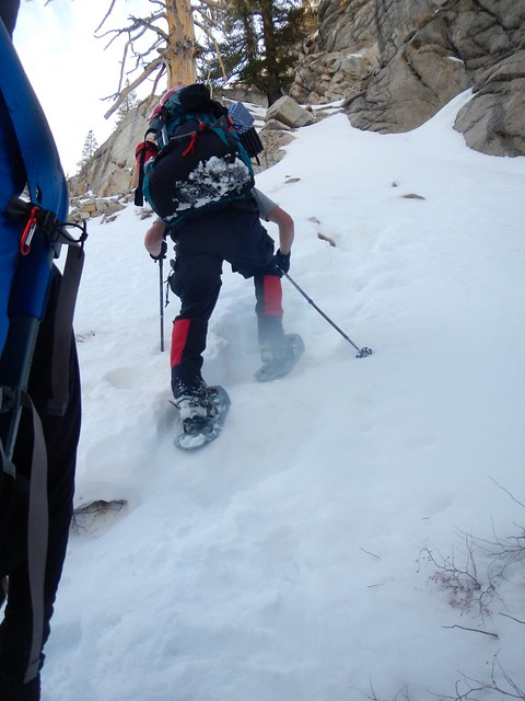
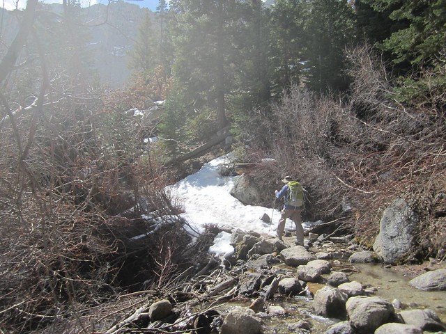
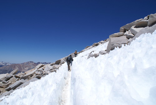
A group from CLMRG (China Lake Mountain Rescue Group) climbed Thor Peak last weekend, and lower sections of the Mt Whitney trail are in these pictures. The group was able to drive almost to the Meysan Lakes trailhead (within a mile of Whitney Portal). Bob reported a good boot track up to Bighorn Park / Outpost Camp, but no tracks beyond that. He said it "would be hard to get to Trail Camp" due to the dry, sugary condition of the snow.
The creek crossing, North Fork Lone Pine Creek -- about 30 minutes hike above the trail head:
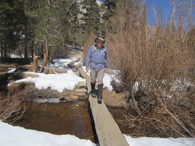
The log crossing:
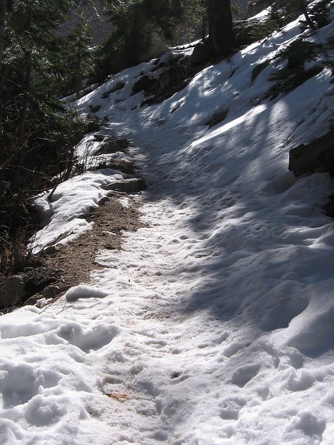
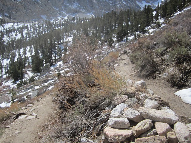
The "trail"
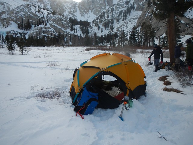
Camping at Bighorn Park
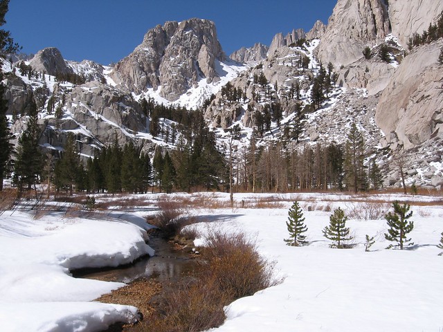
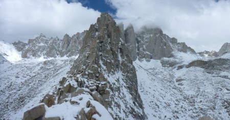
From Thor Peak: Trail Crest on the left, Mt Whitney on the right
Looking down on Mirror Lake. The Main Trail goes through the trees, and up on the granite in the upper right.
My son and I are going up to whitney next week, 23-26. This is our first time. We plan on camping at the portal first night, then to outpost camp the next night. Any suggestions? Do you think we could make it to outpost camp in one day? provided weather is good?
Choclab, you should have no trouble making it to Outpost Camp from the Portal in a day. It is a 2000 ft elevation gain, and there likely won't be too much snow on the trail up to that point.
You haven't written much about your plans, but you might try hiking farther up the trail -- as far as you feel comfortable -- the next morning from Outpost.
Weather at the Portal is reportedly having highs at 50 - 60, so snow should be sparse.
This picture below, of the Lower Boy Scout Lake area on the North Fork is similar in elevation to Outpost Camp. It was taken March 9. I would think you should find bare ground to camp, but not sure. Maybe microspikes, like YakTrax, might be useful.
hey steve, thanks for the info. looks like snowshoes are required. what do you think? provided weather holds up and there is no fresh snow. we have crampons. we have backpacked in snow before, are ready for cold weather. it looks like at lower elevation it won't get that cold (may teens at night). we are planning on driving up from los angeles friday and sleeping in lone pine, and heading out sat. morning. camping either at portal or outpost camp the first night, and evaluating the situation from there. not sure where to go from there if trail camp is a possible or not. or if we can camp anywhere else
Snowshoes were good on that trip as it was a stormy time and it is off trail. If little or no more snow falls between now and your trip, I doubt snowshoes will be useful.
By the way, the Whitney Weather page (link above on the left) has more NOAA weather locations besides Whitney Portal, as well as a number of other links. Be SURE to watch those especially close to your trip.
If the weather is clear, people do drive beyond the road closed sign (at their own risk). If no more snow appears, vehicles might be getting pretty close to the Portal. The road is not cleared beyond the sign, so there is always significant rock fall.
steve, thanks for your suggestions/help. we are getting excited about our trip. have you ever stayed at the whitney hostel? we are planning on spending the night there prior to starting up the mountain. any other suggestions for lodging or favorite places to eat? we are going up friday night and planning on heading up the mountain sat. as far as driving up to the mountain, would you suggest chains past the gate?
steve, thanks for your suggestions/help. we are getting excited about our trip. have you ever stayed at the whitney hostel? we are planning on spending the night there prior to starting up the mountain. any other suggestions for lodging or favorite places to eat? we are going up friday night and planning on heading up the mountain sat. as far as driving up to the mountain, would you suggest chains past the gate?
Hostel is where I stay, and the chains can stay at home. They won't help you any higher than the snow melt itself, and should you need them lower down, it's best not to even try to drive past the gate. Don't leave your car up there unless the forecast is bombproof for clear and dry weather. You may also get a ticket if the Ranger comes around.
I think I have seen somewhere that it takes about an hour and a half to walk from the road closed sign. It is the CHP who come up once every several years to pass out tickets, often just before the road crews open the road -- in May.
Like fish said: Don't venture past unless the forecast is perfect. If you need chains, don't go past.
Whitney Portal Hostel is the best for inexpensive. Bunk beds in a shared room. It is fairly new, and is clean and tidy. If you want an entire room, any motel will do.
My favorite breakfast is the Alabama Hills cafe, across the street from the Hostel. Pizza factory is great for dinner.
No shared rooms right now (off season) at the hostel. Still a good value...you get the whole room for $50 or 60 (1 bunkbed) or $80 (2 bunkbeds), includes all taxes, own bathroom, TV, etc., and you can walk to the good restaurants, supermarket, sporting goods stores. One negative, individual heating system fan runs all night unless you turn the heater off, which is what I do now.
If not at the hostel, the Best Western is quite nice, prices include hot buffet brkfst (not gourmet...but basically passable). Best Western has very nice room furnishings and linens, etc. One downside is you have to get in your car to go to town (1 minute drive).
Best brkfst is Alabama Hills Cafe, yum!
Merry-go-round is very good for dinner--fun atmosphere, and they have both a Chinese and American menu. Haven't tried the American side yet, but Chinese side was quite good. A little pricey compared to home, but competitive for the area.
thanks for your suggestions. will for sure take go for it.
one thing i forgot, is there a ranger station to check in at, or let know that we will be on mountain. want to be sure that if there is any need for help someone now we are out there.
also will i need a gps, or are the triails able to be followed?
is gps better than iphone app?
You have to get permits. Interagency permit station is big building off 395 a few miles south of Lone Pine at turn off to Death Valley. Info re its location is elsewhere on this website.
Your question re navigation gives me concern. Navigating in the snow, particularly above Outlook Camp or Mirror Lake, will not be straightforward at some point. While a GPS is helpful, it is an electronic tool that can fail and should not be relied upon (iPhones are great with GPS-enabled maps installed, but same problem, and you burn through the battery way too quickly ...probably would run out of charge after less than one day if GPS left on continuously). Need to be able to read topo, use a compass. Trail will be covered in snow at some point, very easy to get disoriented unless you have experience with snow travel, use of appropriate tools.
We finally have a trail conditions report this year! Walter R hiked up above Mirror Lake on March 16. He drove all the way to the Portal, and then hiked. His pictures are here: Snowshoe to Trailside Meadow
Walter used snow shoes starting several miles up the trail. Some of his pictures are from off-trail routes. Hikers unfamiliar with the area will find tracks in the snow leading all over the place, not necessarily following the trail. This occurs every spring when snow makes trail travel difficult, and some shortcuts are more appealing.
Several of Walter's pictures:
The first stream crossing (North Fork Lone Pine Creek)
The log crossing
Bighorn Park (Outpost Camp is in the trees) Mirror Lake behind the higher trees. Wotans Throne above that, and Mt Whitney peaking out.
Steve - not to nitpick, but it appeaars people were using snowshoes within about 2 miles of the Portal, not several. The sign for the North Fork is about a mile, and the bog bridges where Walter turned right and headed up the Bighorn Meadow drainage bushwhack are just before Lone Pine Lake, which is around 3 miles. The photo where the 4 fellows are putting on snowshoes is about 1/2 way in between the North Fork turnoff and Lone Pine lake.
FWIW - Doug once told me that once the snow starts to melt, the snowline moves uphill about 500' a week. That factoid has stuck with me.
I've been up the MMWT plenty in these conditions. I do not remember ever pulling out navigation tools. Yeah, there are some mistakes you can make, especially around Lone Pine Lake, and it some of the short cuts willy-nilly but his is really a straight forward hike, just like summer.
Just study the your map before heading up the trail. The first time up that is all I did and there were no major surprises.
my son and i are going up friday and starting up trail saturday. any suggestions on time to start, if we plan on camping at outpost camp the first night? will we be able to make it up to trail camp? is the permit office open on saturday? i will look it up as well.
my son and i are going up friday and starting up trail saturday. any suggestions on time to start, if we plan on camping at outpost camp the first night? will we be able to make it up to trail camp? is the permit office open on saturday? i will look it up as well.
I would suggest starting from the Portal NLT than mid-morning. As to whether you could make trail camp - that would depend upon how fast hikers you are/size of your packs/experience with snowshoes/crampons/level of experience, etc. My hunch is it would be a bit ambitious for you and your son, especially if the snow is as soft as shown in Walter's pictures. Keep in mind also the sun will drop behind the Crest by mid afternoon, and once that happens the temps will drop rapidly. Better if you have a good start on setting up camp by late afternoon - takes much longer/uses different techniques when on snow.
As for when the VC opens - it used to open at 8AM (and not a minute before!) 7 days a week. However, with the budget cutbacks - I'd give them a call to make sure.
The Visitor Center is 2 miles south of town. The road to Whitney Portal is at the stop light (only one in town) - it's about 9 miles to the Portal itself.
In Fishmonger's graphic, the new visitor center is the long building with the silver roof.
where is visitors center in relation to portal/main street?
Choclab, there is a Lone Pine Layout diagram within the Orientation Notes (link above on the left). At the bottom of the layout, it mentions that the Visitor Center is 2 miles south.
The Layout might give you an idea where to find other places in Lone Pine. Do check out the Orientation Notes if you haven't already.
hey w, glad to hear. we are starting main trail by 11am. we plan on making outpost camp, and camping there. stop by and say hi
don't we need permit to be on the trail?
The trail is clear the first mile or two, with snow beginning before Lone Pine Lake. If you start early and it is cold, the snow is solid and easy walking.
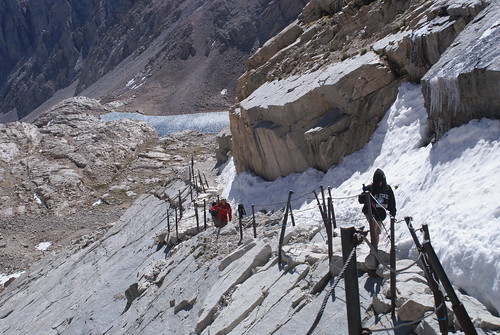
Microspikes work well up to Trail Camp, and crampons and ice axe are best above that point. Until the switchbacks open up, the slope to the west of the switchbacks is easier to climb.
The post includes this regarding someone trying to glissade without an ice axe for braking:
Quote:
On Saturday there was a young man who made it to the summit by way of the snow draw, which is recommended , however he did not have a helmet or ice axe. He thought it a good idea, when descending the draw to glissade. Half way down he lost control and started to cart wheel, for over 500' and there was NO way for him to self arrest, and he ended up in the boulder field below, leaving a giant laceration on his head, lucky is an understatement that he was not seriously injured or even killed. It resulted in him having to be taken out by search and rescue, who did an amazing job to reach him, leaving the portal at 9 pm Saturday night and working all night to rescue him.
Glissading is sitting and sliding on your butt. There are techniques for braking and controlling your speed using an ice axe. Without that is suicidal. And glissading while wearing crampons is a good invitation for a broken leg.
My son and i just came back from staying above mirror lake. This was our first time on the mountain, we used microspikes about .5 to .25 miles from Lone Pine Lake. Slept at Lone Pine Lake Saturday night and were awakened by voices at around 11:30pm, must have been mountain rescue going up after glissader.
Headed above Whitney Zone sign Sunday, microspikes are needed. Traveling early is recommended as the snow gets slushy after 10am. I postholed a lot and even faceplanted a couple of times, gotta love it. Sunday night slept on a nice spot under a tree above mirror lake. Beautiful views of Mount Whitney and Owens Valley. Wish I had a thermometer with me as it got pretty cold at night. Coming down after 10 am just above Lone Pine Lake patchy ice. Past Lone Pine Lake trail cleared up.
Great time, just found out we didn't get lottery pass. Looking to summit in early August. How difficult do you think it will be to get a camping pass?
> How difficult do you think it will be to get a camping pass?
I assume by "camping pass", you mean an overnight wilderness permit. There are cancellations and no-shows every day. Many regulars depend on those -- you just need to learn when they come available.
A good place to read up is in "Step 6" on our Wilderness Permit Options page (link above on the left). Please ask in the Lottery Info or some other thread if you have questions.
Bob R hiked to Bighorn Park / Outpost Camp on March 31. His pictures are here: 2013-03-31 Whitney trail
Bob reported: Ranger at the Visitor Center told him the CHP had been up the road a few days ago and ticketed all the cars, but they drove up to the Portal. The road has been completely cleared already, even with some asphalt patching done.
They encountered the first major snow about two miles up the trail. Below are pictures from Bob's set:
North fork of Lone Pine Creek, and first snow patch
Thanks for the update Steve - regarding CHP ticketing cars at the TH - do you know when the road would open legally precluding the possibility of tickets? I know the opening is weather dependent, but do they have set dates they try and get it open for?
Whitney Portal Store expects to be open on April 19th.
Doug Sr. also reports that "the sign is down". Not exactly sure what that means, but could mean the "road closed" sign is down.
Walter R emailed and reported that on Saturday, Apr 13, he drove to Whitney Portal, and the road is completely open. The "Road Closed" sign is gone.
He hiked to Iceberg Lake on the North Fork route, using crampons. His ice axe was useful for several short glissades.
From his email:
Quote:
It looks like the snow level is at about 10400 ft. I did not take or need snowshoes. I did take a trekking pole with snow basket, ice axe and crampons. Figure the snow level will start going up about 500 ft per week.
Road to the Portal is open (no signs) and clear. I hear the store will open next weekend.
Went up Friday to Trail Camp, only one there that night and had no problems finding the trail. Some of it is snowed over but should not be an issue. Summitted and came back Saturday afternoon. There were trails everywhere thru the snow. A lot of people making their own. Stay to the right after the switchbacks up from Mirror Lake to Trail Camp. Prepare for some minor postholing.
I wore crampons up the chute (west of the switchbacks) but nowhere else (not even sure they were needed due to the soft snow and potholing). No crampons from Trail Crest to Whitney peak and not used to come down the chute or back to Whitney portal. Snow shoes might be more useful depending on how conditions change.
Should have gone up the chute on Friday myself - had to turn around just below the cables, because there was a huge fresh snow pillow blown in that was rather bottomless and in a location where a slide would have been fatal. The cables themselves looked fine, but the last 100 feet below were sketchy. By now that should have all consolidated with a few melt-freeze cycles.
Had the mountain to myself on Wednesday and Thursday on the main trail, so that alone was worth the hike. Wore crampons from Lone Pine Lake up and down.
Considering the meager rainfall we've had this past winter and barring any big late season snow storms would you say the trail should be clear from snow (i.e. no crampons, no ice) by around early to mid June? Thanks.
Considering the meager rainfall we've had this past winter and barring any big late season snow storms would you say the trail should be clear from snow (i.e. no crampons, no ice) by around early to mid June? Thanks.
absolutely. Up to Trail Camp, the trail is at the most 50-50 snow covered, ignoring the recent layer of powder, which by today is probably mostly gone anyway. The depth of some of the steeper snow fields covering the trail reminded me of some early summer snow fields in wetter years. There really isn't much snow on the ground for April.
I have day permit for Monday the 6th and have been watching the weather and it looks like a storm is shaping up. Been monitoring recent posts and conditions too. Does anyone local in Bishop or Lone Pine area have any idea on how conditions might be Monday, would it be worth an attempt to summit? Any input would be appreciated.
It looks like ugly weather, but not bad enough to make it impossible. A few inches of extra snow will make you work a little harder. The lower temperatures should greatly reduce the post-holing. If you're strong and have been there before, you might want to go anyway. If this is your first time, I would stay home or at least be prepared to turn back.
Monday A 50 percent chance of snow showers. Some thunder is also possible. Cloudy, with a high near 26. New snow accumulation of around an inch possible.
If it actually comes through, and does carry moisture, it can make for a tough hiking day. If it turns out to be stronger than the above prediction, it would be miserable higher up. On the other hand, if it fizzles out, you could kick yourself for not going.
Take extra rain and weather gear, go only as far as you feel safe. It will be "an experience" whether or not you make the summit.
Ya bummer didn't start seeing the forecast shape up until the beginning of this week. I think I would still like to attempt, main concern being lightning above the tree line and definitely prepared to have to turn back. Was hoping for a weather window Monday but it looks like that's going to be the main punch
SAT 5/4: Went up North Fork to Mountaineer's Route. Carried ice axe and microspikes, needed nothing until Iceberg Lake. Unfortunately, our day ended there as the warmth of the day had turned the snowfield to slush and we were punching through up to our waists just trying to get to the chute. Reports from another pair coming down said that the chute was complete slush & they couldn't get any purchase to get up. Of course, the rocks are always available, but it was sketchy with the melting snow and sluff coming down, knocking stuff loose. Heard that a group that camped the night before and then hit the chute before dawn, when still frozen were successful. We didn't even start until 9:30 am, so we were hitting that stuff right smack dab in the middle of the day.
SUN 5/5: Went up via the main trail – carried microspikes, but never felt the need to put them on. Was wearing a pair of New Balance 910 trail shoes and a 10 lb day pack. Started at 8:40 am. Only small patches of "no big deal” snow until the switchbacks – but even then it was soft and the footing was great. Summited around 3 & a storm was whipping up, temps dropped. The snow was starting to harden up on the way back and I was glad to have carried an ice axe for "confidence.” That said, my boyfriend never pulled his out and was fine – I'm the safe one:) I was particularly glad to have it on the snowfield on the south side of the summit, since I was in running shoes. If I had been backpacking and carrying a bunch of weight on my back, I would have definitely needed it! As we descended a light snow began to fall (between Trail Camp and Mirror Lake), so I don't know what that did up high. The sky would alternate grey and opening up to sun the whole way down, so who knows?
Beautiful weekend up there - can't believe it's May.
Yeah, I've been using this forum a lot to see what's going on up there, so I figured the least I could do was return the favor!
We got back to the trailhead a little after 7 - never needed the lights we packed, which was nice. The snow & heavier packs (than usual for running, thanks to extra gear) slowed us down, but not as much as we thought. We were able to run/jog a lot of the way back down.
To answer your question on "staying in shape," we run 60-100+ miles a week, pretty much all on mountain trails. We're in the Santa Monicas by week & every weekend hit either the ANF front range or high country, Baldy, Gorgonio or the Eastern Sierras. That said, I'm good as long as I'm moving light and quickly - but backpacking with 30 lbs on my back is a whole different animal. We did a 3-day trip last fall that all but destroyed us!
Got to portal Sunday the 5th, was unexpectedly warm and clear. We got on the trail about 530am the next day and made progress fairly quickly. We saw very few people on the trail only. We got to the base of the switchbacks at about 9:15 and took a while going through the snow section used our ice axes on the cables section and some of the more iced up sections. Weather started to turn as we could see clouds moving in from both sides of the mountain and we made the call to turn back just before the trail crest. The way down it started snowing pretty heavy and didn't stop the whole way down. We made it back to our camp at about 3. Thanks for everyone's advice and posting on the forum.
Thanks everyone for these updates, they're incredibly helpful in planning! My boyfriend and I plan to hike Whitney, via the main whitney trail, this coming weekend, forcasts show showers all week, but clear and sunny both saturday and sunday. From the video it looks like mostly loosely packed snow. I was wondering if anyone felt the need to put on crampons or even bring them? We're both pretty avid summer hikers, but winter hiking is new to us, and we want to be prepared for whatever comes. we had planned on renting plastic boots and crampons, but since the dry winter would we be okay with hiking boots (with gaiters), poles, and an ice axe? thanks again for these posts!!
Thanks everyone for these updates, they're incredibly helpful in planning! My boyfriend and I plan to hike Whitney, via the main whitney trail, this coming weekend, forcasts show showers all week, but clear and sunny both saturday and sunday. From the video it looks like mostly loosely packed snow. I was wondering if anyone felt the need to put on crampons or even bring them? We're both pretty avid summer hikers, but winter hiking is new to us, and we want to be prepared for whatever comes. we had planned on renting plastic boots and crampons, but since the dry winter would we be okay with hiking boots (with gaiters), poles, and an ice axe? thanks again for these posts!!
While you won't know if you'll need crampons until you're there, you don't want to be in a position where you should have them but don't, especially with changing conditions like the mountain has seen over the past few days (it is still Spring after all and snow is always a real possibility). So, If I were you I would pack them. It's only a pound or two that can make the differences between summiting and not, or worse. My two cents. Poles and an axe should be standard equipment this time of year. If you're not familiar with crampon use and snow travel, I'd suggest testing them out and practicing on some more mellow snow slopes in the area before taking them on Whitney for the first time.
Mt Whitney has been enshrouded in the clouds for several days now, with light rainfall hitting the lower elevations. I am sure you will be hiking in fresh snow. Only question is how much. You will appreciate the crampons.
We were planning on climbing East Buttress this Sunday, but if even if the weather clears up this weekend (as forecast) these last few days will probably make the climb a wet mess. Even with the May sun I don't think its likely to dry out until early next week. Unless anyone thinks differently. When all else fails, crampon and ice-axe up the MR.
Does anyone have suggestions on camp in these conditions? Maybe Upper Boy Scout Lake? I imagine Iceberg is frozen solid with only snowmelt for drinking/cooking?
Thanks everyone for these updates, they're incredibly helpful in planning! My boyfriend and I plan to hike Whitney, via the main whitney trail, this coming weekend, forcasts show showers all week, but clear and sunny both saturday and sunday. From the video it looks like mostly loosely packed snow. I was wondering if anyone felt the need to put on crampons or even bring them? We're both pretty avid summer hikers, but winter hiking is new to us, and we want to be prepared for whatever comes. we had planned on renting plastic boots and crampons, but since the dry winter would we be okay with hiking boots (with gaiters), poles, and an ice axe? thanks again for these posts!!
Myself and a couple of friends are headed up this weekend as well although we wont get started until Sunday early. Good advice has already been given and we will all have axe/crampons as suggested. In my experience it may not be necessary to go up with crampons but you sure will want them when headed down. This happened once to me in Canada (Garibaldi)- cruising on the way up and super sketchy on the way down. Never really liked looking down a 40 wet slope to a 700+ drop off. I've never left without them if there was even the slightest possibility since. We will overnight at trail camp and summit Monday if the weather holds. Good luck and lets hope the mountain gods are good to us!
Hey Joe, I was going to head up today with my brother in law and cousin to introduce them to the trail with a quick trip to LPL. I'm guessing that we wouldn't have needed cramps up to LPL, but probably better that we didn't head up this weekend. I was overruled with "it's mother's day", so we are sticking with a local hike today.
It's looking like we are going to shoot for a late season two or three day summit attempt.
Was able to catch the first break in the weather and summit yesterday. Luckily one person broke some of the trail from trail crest, but broke the rest in knee to waist deep snow. Its melting off fast so the route is in good shape now. Having the summit to yourself for awhile was amazing! People should have no trouble now up high. The chute is really the only option for ascending from trail camp. Trail to LPL is clear, some snow as you approach trail camp. I'll post some pics on my blog in a day or two. I'm beat!
we plan to go up there on may 22nd, camp at trail camp overnight and summit on 23rd. is crampon and ice ax needed if we are using 99 switchbacks? thanks.
People who have been up this month have been using them. I don't think the worst spots will be clear by that time. The worst places are the top of the switchbacks -- that one last long section that heads over to Trail Crest, and at the cables.
When you go, if the conditions are good (it is warm), the snow will be slushy and regular boots will grip well. But if it is cold (as if you return from the summit later in the afternoon), the snow could freeze up, making the same sections treacherous.
I was fearful for conditions up high since I arrived at the trailhead on Friday 5/10 and it poured rain from 3p-10p. Saturday brought cool, crisp air to hike up and there was even a lingering snow shower near trail camp.
Saturday 5/11 brought remarkable blue sky and calm winds. I made steady progress up the chute, passing a few parties. I didn't use (or have) crampons but was in heavy duty mountaineering boots and had an ice axe and adjustable ski pole. I arrived at Trail Crest with one other climber who was waiting for a group. The wind had picked up so I started hiking again. There was a broken trail until the Muir Trail branches off then it was all mine to break/enjoy:)
This section until just short of the summit was some of the toughest conditions I've experienced. Thick, breakable crust, deep wind drifts, hidden holes between boulders...I almost turned around multiple times and taken the easy trail the next day. Instead, I pushed on and on and was able to get to the summit as a party of 4 was leaving on the Mountaineer Route. According to the summit register, I was the first person in 3 days to summit from the trail side. Having that summit to myself for awhile is something I'll never forget. I also met a nice couple from the UK who were hot on my heels and made it car to summit to car that day. Nice work!
I'll have some more photos from around the Lone Pine and Eastern Sierras up on my blog on my next post.
it is just a few days before we hit the road to visit Whitney. hopefully, we can see more postings for those who have made it in the past few days to know more about the trail condition.
btw, where can I find a break down of each of the legs (distance and time)? we will be camping at the trail camp for a night before summit on 23rd. thanks.
George, Reno Frank sent me a document he had put together with legs and times. It was in a WordPerfect format, I think. I've copied his numbers here. If you copy and paste these numbers, be sure to use a fixed-space format (monospace font, like Courier).
thanks a lot. we are leaving early tomorrow morning and will post pictures and trail conditions while we can. do you guys recommending taking the 99 switch back or the snow chute to the east right under the trail crest. we have full gears. crampon, ice ax, one rope team. thanks.
Also, if taking the chute, do folks have suggestions on (1) best window of time to hit the chute going up, and (2) best window of time to hit the chute going down.....
thanks a lot. we are leaving early tomorrow morning and will post pictures and trail conditions while we can. do you guys recommending taking the 99 switch back or the snow chute to the east right under the trail crest. we have full gears. crampon, ice ax, one rope team. thanks.
George, since you have full gear, going up the slope (chute) will be more direct and easier. Coming down, you can decide.
I would definitely talk to others you meet on the trail and ask what they did.
From what I have read, the snow from a week ago has nearly melted away, so there is probably a boot track up the switchbacks again.
I've not seen anyone ever need or use a rope in that area, so you might find it to be extra baggage.
Originally Posted By: Akichow
Also, if taking the chute, do folks have suggestions on (1) best window of time to hit the chute going up, and (2) best window of time to hit the chute going down.....
Thanks!
Karin, early is best going up, mainly so you can get to the chute before it falls in the shadow of the Whitney crest, cools down and ices up. If you can time it so you are back to Trail Crest by 2 PM, I think that would be the best time. If the weather is especially warm, then later should be ok.
Thanks, Steve! And by early, you mean .....? Doing this as a backpack, so please tell me what you really think...have some flexibility on summit day start time from camp. (Getting back to Trail Crest by 2 should not be a problem). Thanks!
If you are camping at Trail Camp, right at the foot of the switchbacks, an 8 AM start should be just fine. If you're camping down at outpost, then start earlier, say 6:30.
If it is a cold morning, it will take time with sunshine to warm the icy conditions. On a warmer day that won't be a big deal. And going up on harder snow is easier than coming down in the same.
i have a day permit for June 9th, (Sunday). We are spending a couple of nights at the Whitney Portal and i wanted to know what kind of a weather(temperature) we can expect there. Also, do you guys think the switchbacks will be open by then, and where can i find the details so i know what kind of gear to pack.
Here is a link for a 7-day forecast for 12,800' in the Whitney Zone... basically what you can expect at Trail Camp. (Ignore the top line, which has current conditions for Bishop, and scroll down to where the 7-day forecast is.)
i just wanted to share my recent experience climbing mt. whitney. i hiked it with a friend, from may 19th-21st. the weather was perfect. we camped at trail camp on the night of the 19th, hiked to the summit on the 20th, and descended on the 21st. the switchbacks were mostly clear, the only hazardous parts were at the cables, and the switchback at the very top, which is still mostly covered in snow. there is also a lot of snow from trail crest to the summit, but it's very manageable.
i didn't use crampons or ice axe. i had a new pair of hiking shoes, and poles, which seemed to be sufficient for the majority of the hike. some sort of extra traction would have been really nice for the couple of spots i mentioned before. my hiking partner had microspikes, which she found really useful. this was also her first time backpacking!
i imagine with as fast as the snow is melting, conditions will be different from day to day for the next few weeks. i would guess that by mid june, there will be no snow left on the trail, barring another snowstorm.
That may not be the last switchback, based on the view down and the view up at the end of the video. There are a couple of places on the switchbacks where care must be taken (not just the cables and last switchback) though conditions are changing very very rapidly.
June 3: I have seen others writing and posting that the Main Trail is pretty much free of snow, with some care required on snow at the cables, and several other patches.
Most people are hiking with only hiking poles, and no technical gear.
I snagged a permit for June 10th yesterday and had a few questions. I never hike with poles and am confident without them. Do you think they are necessary for the few snow patches that remain?
No, poles aren't mandatory. Just understand that if it turns cold (as in cooler weather and later in the afternoon), that snow you cross can ice-up and become quite slippery. So watch when you go up, and imagine walking down over it. If it isn't too bad, you're ok. If it is, then make sure you get down before icy conditions set up.
To kind of piggyback off that question, if I may...
Two first timers with permits for tomorrow and Thursday. Do you suggest we bring crampons and ice axe for the current conditions?
I know you mentioned some areas of ice. We plan on talking to people on their way down and we know we might have to move once the sun has heated up the ice as well.
If you are taking the main trail there is no need for ice axe and crampons. There isn't enough snow to arrest on anyway. If anything i would bring a set of micro spikes.
I was up this last Sunday with two first timers. We all brought micro spikes and none of us pulled them out. we did all use poles though which I thought were helpful in the small amount of snow we did encounter.
Thank you for the advice. We are taking the main trail, camping at Trail Camp. We're starting every early (3 am), so it will give us time to push if we feel good enough for a 1 day hike or if we need some rest and have it make it two days. We feel pretty prepared, we've done a lot of 10,000+ hiking.
The snow/ice was our main concern, as we did not want to pack gear we didn't need. But from the sound of it, hiking boots and some extra care around icy areas seems to be okay.
It looks like the need crampons/spikes passed a few weeks ago assuming it's not an early morning endeavor when it's icy. Ice axes also sound unnecessary for the ascent if there are poles involved and some comfort on snow.
My question is: Is there enough snow (in suitable condition) in the chute for glissading (and thus a need for an axe) or is that no longer an option? I assume it's down to rocks at this point but would love to slide down it again if at all possible and couldn't find any comments/pictures detailing it's condition.
Since you want to that badly, I'd carry the ice axe and go for it. There might be some rough spots, but with the axe, you can always stop and move to a different groove.
Should I be worried of this little Sunday-Monday storm rolling in? What I mean is, worried about the amount of snow that will fall and cover the switch backs? It warms up significantly on Tuesday which would be our summit day so maybe a later morning start would suit us best.
I hate this waiting and watching period of planning!
Crazy weather! Record highs on Saturday, followed by chance of snow showers on Mt Whitney by Monday. Tuesday looks like an excellent day.
The weather forecast for Sequoia N.P. is for 20% chance of rain. NOAA says 30% near the crest. With that low a chance, I sure wouldn't worry about too much snow.
But be prepared -- it could get cold and windy, so take extra layers, and something to keep the rain off. WB Travis has often written here about freezing conditions on Whitney in the middle of summer. It can happen.
What's the weather like at Whitney Portal campground? I'm camping there Sunday & Monday. We start our 3 day hike on Tuesday.
The Feature Topics box just below the webcam images on every page, above on the left, has a link to the "Mt Whitney Weather" page. On that page, there is a link (second one down) to "Whitney Portal weather"
When you click on the Whitney Portal Weather, it opens a NOAA site that shows a 7-day forecast. Unfortunately, right at the top left of that page it shows a bogus "Current Conditions", that is for the nearest NOAA reporting weather site. Please ignore that, and scroll down a little, to the "9 Miles W Lone Pine CA -- 7 Day Forecast" part. THAT is what is predicted for Whitney Portal.
Sunday and Monday look very pleasant, only with a chance of a thunderstorm on Monday.
I hiked Whitney yesterday, and conditions are the Portal are similar to rest of the high desert - temps are well above normal, but expected to diminish beginning today.
In terms of trail conditions - the cable section shown in Bob Rockwell's photos have melted out a bit more. Just use a bit of care there, and in a few of the switchback corners, and no worries. The snowfield near the summit has a well-beaten path thru it. No need for any type of traction aids or ice axes, although several people were carrying them. And I'd echo Bob's comment re: skeeters - lots of them down low, especially in the morning.
Lots of folks on the trail yesterday - almost a carnival-like atmosphere. It was probably the warmest I've ever hiked Whitney, but even so, it wasn't unreasonably warm.
A most excellent description -- especially the switchbacks; a completion of the atmosphere would be a 'fist bump' every time you connect with the same people....over and over. The only other time that I have experienced this same atmosphere in the 'wilderness' (que up the audience laughter) was Half Dome. Both destinations are uniquely stunning with ease of access, but the "confluence of incongruities" (to qoute Les McCann) is hard to take at times.
Does anyone know what the conditions are like on the mountaineers route? I mainly want to know if crampons / axe will be required and is the final 400 icy. I have permits for 6/23, planning to go up mountaineers route and come down the regular trail in a day. Also is the route well marked? Its my first time up Whitney and I am planning to start when its still dark.
drekin: Based on the lack of snow on the Main Trail, the MR should be mostly clear, too. I wouldn't take the crampons or the ice axe. The final 400 should be clear enough to avoid what ice there is.
On your last question: No, it is not well marked! It is a "route" and NOT a trail. The Inyo N.F. website is extremely misleading. I've tried to get them to change it, but there is some bureaucratic reason for what they have. Here's the description from this link:
Quote:
The North Fork Lone Pine Creek Trail is in the John Muir Wilderness. The trail is steep, rugged and difficult to follow. It provides access to Mt. Whitney's Mountaineers Route, East Face and East Buttress, as well as to Mt. Russell's Fish Hook Arête and East Ridge. The trail ends at Iceberg Lake, at an elevation of about 12,600 feet.
Let me repeat: There IS NO TRAIL. There are a few places where you will find a well-beaten use-trail, but for lots of it, if you do not understand where you are going, you will just be lost. If you start in the dark you are fine up to the North Fork L.P. creek. Then there is a path to follow another 15 minutes. Then paths split. Both splits come come together at the base of the Ebersbacher Ledges. A first-timer should NOT attempt the Ledges in the dark.
Thanks a lot Steve, I'll take a look at the forum and make a decision. Given that there is no trail I'm leaning towards taking the main trail since this is my first time on Whitney.
I don't remember, I was toying with the idea of hiking Whitney last year but I did not get a permit, and I thought it would be more scenic and interesting if I did a loop (i.e., mountaineers route up, main trail down).
I noticed you mentioned you did not have a permit, keep in mind the loop you are considering requires 2 permits. One for the MR and one for the MT. The MT is a lottery permit (but some are available still) and the MR is reserved 6 months in advance in most cases through www.recreation.gov. The MT permit does not allow you to take the MR and vica versa.
I noticed you mentioned you did not have a permit, keep in mind the loop you are considering requires 2 permits. One for the MR and one for the MT. The MT is a lottery permit (but some are available still) and the MR is reserved 6 months in advance in most cases through www.recreation.gov. The MT permit does not allow you to take the MR and vica versa.
Just a heads up in case you did not know.
I appreciate your writing, scuba, but some of the above is incorrect.
To make it clear, the two-permit requirement is ONLY if you backpack and spend the night on the Mountaineers Route (North Fork Lone Pine Creek), and then want to exit via the Main Trail. (The second Exit Permit is also required for backpackers entering any other Inyo N.F. trail and exiting the Whitney Main Trail.)
If you are day hiking, you only need the "Day Use Whitney Zone" permit, which permits people to go up EITHER the Main Trail or the North Fork (non-trail) route. With the Day Use permit, one can descend either way, as well.
Both the Day Use and Main Trail Overnight permits are within the lottery. The North Fork backpacking overnight permits are not in the lottery, but are like all other non-Whitney-Main-Trail permits: Available online up to 6 months in advance.
Climbed Mt Whitney by the main trail on Saturday. Perfect weather conditions.
Snow condition: Trail is 98% snow free. There is some snow in the cables section which can be avoided easily. There is about a 30ft patch of snow right before you get on to the final plateau, but there is nice track through the snow patch so no danger whatsoever regarding faling or slipping.
Some small points from my experience 1. Dont carry too much water. We carried 2 liters per head and refilled at trail camp with a filter while climbing up as well as climbing down. We didnt even have filters but had iodine tablets. Many thanks to the fellow hikers who let us use their filter
2. Apart from trail camp, there are plenty of more water sources on the trail too.
3. Carry food with lot of carbs and bananas. You will need it to restore the energy once you reach the top.
4. The 99 switch backs never end. Just keep walking at a steady pace LOOKING DOWN on the trail.
5. The stretch from trail crest to the summit, is the most grueling according to me, although you gain just 800ft. The trail is very very rocky and you need to be extra cautions about your footing as there is a steep drop on one side. Plus your legs will be tired from already climbing for around 9 miles. Be mentally prepared for another 2 hrs of strenuous hiking from trail crest to summit. We thought it will be relatively flat, but were sorely disappointed after starting on that piece of trail.
6. Start as early as possible. We started at 3am, and could make it back within a relatively good time, but you always will want to spend some more time at the top.
Other than that, just have fun on the hike! Its difficult trail but not impossible
Summited July 3, 2013. No snow issues. Left portal at 1 AM, weather cool, two Icebreaker shirts, light hiking shirt, long hiking pants....trail camp around 530 AM, little chilly while replenishing water....up switchbacks, warmed up, t-shirt and shorts okay....little chilly when wind picked up in shadey areas...summit at 830 AM, 12th person to sign in at the top for the day. Good trip, good weather, plenty of water.
Bulldog34 posted these on Facebook, taken July 25, I believe. They show the results of a heavy downpour from the recent weather that passed through. With this much down at the Portal, there had to be some tremendous rain higher up.
Does it seem to others that this summer's weather has been very wet compared to others? When I look at the web cam I do not recall seeing so many overcast/cloudy/rain days in the past.
Yes, thanks for the pictures. Poor Prius and econoboxes. I hope they were able to get out with all that dirt and mud. I got lucky a few weeks ago and got in the perfect window, right after an early July storm and right before this latest wetness.
John, I think it was worst last year. I remember watching the weather reports for a few clear days to go up there and remembered it raining by the afternoon almost everyday.
I just finished 10 days up high , had lunch at the Portal today with Doug. never saw a mosquito despite the recent rains, never took out my bugnet or bug spray. of course, the few bugs that are there might like you more than me !
August 15: There is a report that the spring crossing switchback 23 is dry in the morning, but running ok in the afternoons. It is fed by a snow field farther up the slope.
That means last water on the way up is the Trail Camp pond. I have always made my way to the inlet of the pond, and filled my containers without treating or filtering.
I am a first-timer and heading up 8/23/13. It looks like there are thundershowers predicted the days before our hike. If it does rain prior to hiking what does that mean in terms of the trail? Thanks!
The trail is high and dry. After any rain, there is usually no problem, just less dust. There is no place on the trail where anything can become swampy.
The bigger issue is if it storms while you are hiking or camping on the mountain. Since the area is so high, what might just be light rain lower down can be icy and windy on the trail.
Watch the weather forecasts for conditions during your time on the mountain, and be prepared.
The spring at the switchbacks was running strong and sounded like a river when we came down(11:30am) the mt on the aug 18. When we went up there was nothing(7:00am)
I am a first timer too, RJS...hope to summit on 9.11...just wanted you to know I am excited and terrified all at once as well...please post how your experience went and best of luck!!!
The bigger issue is if it storms while you are hiking or camping on the mountain. Since the area is so high, what might just be light rain lower down can be icy and windy on the trail.
We were at Outpost Camp Sunday night when the storms hit. 3/7 ended up hiking down and spending the night in a hotel. 4 of us stayed at camp and ran into lots of ice and snow/hail above Mirror Lake. If I had never been on the trail before, I don't think we would've been able to find our way to Trail Camp.
By the way, there is a comment that since this "spring" dries up overnight, it can't really be a "spring". It is actually snowmelt from a bowl above the trail where there is a snow patch that pretty much remains all summer. So when the melting stops, either due to cold temperatures or the snow finally completely melting away, this spring dries up.
The water does travel underground (or at least under the surface broken rocks) from that snow patch, and it reappears at the surface on the switchbacks. So whether it is called a "spring" or something else can be left to debate.
Bottom line, though, is that most regulars will dip and drink from this water source.
I'm planning to do an overnighter on Sept 29th. What are the chances that there will be snow on the main trail? I'm thinking of just heading to Trail camp and coming back if it looks like I cant manage it with micro-spikes. Thanks!
Hiking the MWMT this weekend, bringing some friends. It looks like its been COLD. Are the switchbacks sporting a running spring during the afternoon? Has it snowed recently and is it sticking?
"As of 9-22 the spring on the switchbacks is dry (passed it mid afternoon). Patchy snow was still present in shaded, north facing areas. Just a dusting. Ice may be an issue depending on location and timing. Watch the forecast between now and w/e...."
Cam, viewing the webcam daily sets, Mt Whitney has been virtually cloudless the past several days, so pretty balmy weather, but likely chilly. I think you are going to have a really windy experience at Horseshoe Meadows tomorrow, so be prepared with warm clothing.
With that chance of snow, and if you can adjust your schedule, you might inquire when you pick up your permit about trading your permit for Friday. It looks like Friday will be calm and clear.
That snow prediction is for a light dusting, so you you are prepared, it shouldn't affect the trail. We would sure like to hear how it turns out!
sierragator has some pics on facebook for the Mountaineer's Route. There is snow in some places, mostly around rocks and in crevasses, but shouldn't be a problem on the Main Trail. Just be careful, as the granite up there is pretty slick when it gets wet. Would love this thread to keep updated as far as the new snowfall on Thursday. Pics would be appreciated.
Heading up for a two-nighter from 10/02 - 10/04 for my first time to the summit. Looks like it's going to be pretty cold, report shows chills as low as 10 degrees this week. I've got lots of layers (base, mid, fleece, puffy, shell), a pair of gloves and a beanie, but is there anything anyone wishes they would have brought or did bring to make sure warmth wasn't an issue? I've also got a 20 degree down sleeping bag as well as a liner.
I was up in the air about microspikes, but I would rather be prepared than be up there wishing I had them. Thanks for the advice. Those cheap ponchos do go a long way too.
I'll be up there with a group this week too (Portal Wed night, then overnight at Trail Camp on Thurs, hoping to summit Friday morning). Looks like it will be breezy at best and chilly!! (forecast of 17 at trail camp Thurs night!!) Definitely bringing a couple extra layers now!
Still waffling on if I bring the microspikes or not... I know the first snow came last weekend, and there's a 20% chance of dusting on Thurs... but I don't know that there'd be anything for the spikes to bite into (unless it turns into a storm, at which point we'll be heading down not up)
See you guys up there!! (I hike hot, so I'll likely be the idiot who looks like they're not wearing enough layers for the weather but is sweating up a storm haha)
I think we may miss each other, we'll be following just a few days after you. We'll be at the portal on the 1st and head in on the 2nd. If you wouldn't mind, let me know how conditions are when you're back.
On the main trail, there will be many people doing fine without microspikes. This isn't a lot of snow, so plain hiking boots should be ok. Take the microspikes if you already have them -- they could provide some confidence.
...or they could be the extra weight that slows you down too much. It is certainly your choice.
Was up there the last two days. Thursday it snowed off and on most of the day. About an inch or two stuck around from Trail Camp up.
Yesterday was clear gorgeous blue skies, with wind only hitting us about half way up the switchbacks, then around the final push up the back side of Whitney
Heading up the switchbacks it was snowy but not too icy. We summitted around noon, then headed back down (after a a very windy 45 minutes on top) By then most of the snow had been melted/walked away. On the way down, the cables were snowy but not too icy. Microspikes weren't needed, and I think there wasn't quite enough snow for them to bite into.
As long as more snow doesn't fall today, microspikes definitely won't be needed this weekend.
9/28/13 Day hike from Whitney Portal to the summit.
Trail was totally clear of snow except for the cables, which had a fairly fresh hard pack of lingering snow from the 9/26 dump. Manageable without micro spikes, though trekking poles helped a lot. There was no running water at the switchbacks that I could see.
Planning on MR this Saturday. I did this route 5 times but never in October. Forecast is very good but I'm wondering about the ice along the route, like the slabs below Clyde Meadow, and maybe some more higer up. I can take microspikes if necessary. Anybody? Thank you.
Pic is from yesterday, but just a little snow on the 400, easy to get by. The chute doesn't have much either, but what there is, leaves you to have to walk in the scree a lot. So you'll need to work with that. Really crowded the day we went, with as many as 18 people in the chute at one time, lots of sliding and falling rock. No one got hurt. There is a report under Trip Reports. On the way down, the only snow or ice is at the cables, but again, not a big deal. Lotsa wind the day we went up. If you're gonna go, do it now, as the window is closing.
Hi all, I would first like to thank everyone on this forum with all the helpful advise that I've read on here. As you may have experienced yourself, my hike up to the Summit was a year and a half in the making and have gotten a lot of helpful info on this forum. I Summited on October 1st 2013! Id like to contribute the conditions I faced during the 3 days and 2 nights I was on the mountain:
Weather: Clear, no clouds to be seen for miles and miles. It was however in the 30's at Trail Camp. The tip of my exposed Camelbak was frozen in the a.m. Light winds.
Trail: No snow or ice to worry about. I saw a lot of people carrying shoe chains (including myself) and it wasn't necessary. I counted 98 switchbacks...WTH?
Water: Last water is at Trail Camp.(not sure if there is suppose to be water higher than that?)
When I was coming down the mountain on the 2nd of October, various hikers going up were saying "there is no government down there" being out of communication for a few days, it took me a few to figure out what they were talking about. As of this morning, there was no Park Ranger (as there was when I went up on 31 Sept 2013) to check for permits before the Whitney Zone. There were no closure signs or tape anywhere to be seen.
We hiked up on Saturday the 12th. The trail had a lot of ice on it, very sketchy coming down in the morning when everything was still frozen. We camped at the Trail Camp, 1/2 foot to a foot of snow in some places, we had to clear snow away to make our campsite. We decided to cut our losses and head back down Sunday Morning.
Everybody we met on the way up that had made it past the 99 switchbacks said that there are snow drifts around knee to hip high and that it made it extremely difficult to get to the top. We didn't meet anyone who had actually made it to the very top. I would definitely recommend crampons or micro spikes, gators, good waterproof boots and lots of cold weather gear, it was frigid towards the top.
So I summited the Mountaineer's Route on Saturday afternoon and descended the Main Trail. Hopefully I can shed some light.
For Mountaineer's Route: -The chute still has about a foot to a foot and a half of snow in the middle of the chute. We went to the right of the chute and it was fine, but there were a few sketchy icy sections. We had to traverse at one point over the chute, so we definitely needed our ice axe there.
-The Final 400 had a bunch of snow on it still. We started in the middle and there was a layer of ice on the whole shelf. We took the right side of the left chute and there was enough ice/snow to make it very precarious. Didn't feel comfortable downclimbing without a rope to belay, so we took the Main Trail down.
For Main Trail: -Still lots of snow from the summit down. Definitely do-able with just microspikes or just poles. The switchbacks down from Trail Crest have probably 1-3 inches of snow but its packed enough to easily get through.
I'll re-upload some of those photos (esp of the chute). Out of our party of 10, just two of us summited. One in our group got really bad altitude sickness, so some went down with him, and the rest didn't feel comfortable continuing on, which was a bummer. Wish we brought a rope!
A friend and I went up the Whitney Trail Mon night to Trail Camp, summitted Tues and hiked back out. Keychain thermo said high 20s at night, @ 12,000'. Lakes weren't frozen over yet and streams everywhere had enough for filtering. Some ice, snow on the way to camp, nothing sturdy boots couldn't handle. 99 switchbacks all the way to the peak has hard, packed, squeaky snow, which again, no problem for real boots.
Cables:
From summit looking down:
Trail Camp:
Trail Camp:
From the notch:
Back of the spires, on the way to the summit from notch:
My wife and I hiked the Mt. Whitney trail last week (10/22). We managed the crux (finding the postage-stamp sized trail sign at 5:45 am) and found ourselves switchbacking up an amazingly urbane trail. Urbane as in your governator could probably take a wheel chair up most of it if he set his mind to it. Above the second camp we donned microspikes (recommended). We also had a whippet with us but didn't use and I wouldn't take one again. The snow was firm and we didn't have to do any post-holing. We topped out under sunny skies and enjoyed a couple of bottles of Sierra Nevada at the top of the Sierra Nevada, seems appropriate (however if anyone tells you a beer helps with an altitude headache, it doesn't). With half a dozen stops (including about 45 minutes at the summit) the round trip took us about 12:45.
Some observations:
The average size of the pack people take on this trail seems to be about 120 liters. The first time I passed by someone with a one of these monsters I assumed they were Gideons packing two dozen bibles up to the summit shelter. After seeing that everyone had packs that big, I realized that's just how people roll around here. (Our packs, together, were less than 30 liters).
Also, Californians like to where there puffy coats. Even when it's 65, and they're hiking uphill, with a pack.
Congrats Jake and your wife! And thanks for the conditions report and pictures.
With a 12:45 round trip, you two are in great shape. I am curious what you do for conditioning.
Also, I had to look up whippet. Still not sure... a dog? a whif of Nitrous oxide from whipped cream canister? Or guessing here -- a canister of oxygen?
Besides the "headache in a bottle", what did you do for water on the hike?
Also, I had to look up whippet. Still not sure... a dog? a whif of Nitrous oxide from whipped cream canister? Or guessing here -- a canister of oxygen?
Oh good, I wasn't the only one! One thing that did come up in my search was 'Black Diamond Whippet Self Arrest Pole'
Yes the Whippet is a self-arrest tool used for ski mountaineering. Not something you would want to rely on as an ice axe, but in emergencies it might help arrest a fall.
As for pack size, that obviously depends on the plan of the hikers/climbers. Since you were doing a one-day trip obviously your pack will be much smaller. For someone taking two or three days to acclimate and go at a leisurely pace, the normal demands of a tent, stove, extra food, bag, etc. will obviously dictate the need for a bigger pack. Of course it's up to each person to decide how they value comfort vs. weight, as long as it doesn't compromise safety.
Per a call to the Eastern Sierra Interagency Visitor Center this morning, Monday's storm brought "very light snow" below 10,000ft and a "light dusting" of snow above 10,000ft. They strongly recommend crampons due to icy conditions but don't believe snow shoes are necessary.
Congrats Jake and your wife! And thanks for the conditions report and pictures.
With a 12:45 round trip, you two are in great shape. I am curious what you do for conditioning.
Also, I had to look up whippet. Still not sure... a dog? a whif of Nitrous oxide from whipped cream canister? Or guessing here -- a canister of oxygen?
Besides the "headache in a bottle", what did you do for water on the hike?
I've been doing Mtn Athlete Base Fitness twice a week in the morning for years. Other than that my training is as capricious as the Alaskan weather. I did a lot of peakbagging this summer where I'd take a really light pack, run where I could and hike the rest. I put in some pretty big days this way, and did a lot of long trail runs. My wife did an Ironman in June and runs 3:30 marathons so I just do what I can to keep up with her!
Seriously, though, we weren't going that fast. We took half a dozen rests, including probably 45 minutes at the top. I bet someone who nodded in the direction of acclimatization and made an effort to jog intermittently could probably do it in around 10 hours.
The whippet is a ski pole with a small ice axe head. That and micro-spikes are my dirty tricks for fast peakbagging. They open up a lot of terrain to getting climbed in trail runners. Although boots, proper crampons, and and ice axe still have there place, you will slow down a lot on easy, snowy terrain compared to the whippet/micro-spike/trail runner setup.
For water, I carried a 2-liter Platypus Big Zip (awesome product which I highly recommend). It was full when I started and I refilled (~1.5 liters) on the descent at the first lake at the base of the long section of switchbacks.
Let me know if you have any other questions. I love to talk training and gear.
Hiked main trail to summit over 11/2-3. A few patches of ice below Trail Camp, easily navigated. However, above Trail Camp trail is almost entirely snow covered. Microspikes & poles provided enough safety. I wouldn't go up without them.
Overnight temp at Trail Camp was 17. Moderate winds. Summit temps were in the teens with wind chill. Sunday was very blustery, but crystal clear.
Lake at Trail Camp was frozen over, but a small hole allowed for filtering water. Don't think it will last much longer. No signs of bears or marmots. Overall, a great trip!
With this heavy snowfall this late in the year, the Whitney trail is pretty much a snowshoe hike at this point. Only a few hardy souls will be heading up. What usually occurs is that people will start up, then lose the trail and head off in various directions, resulting in many spur tracks to nowhere.
Once the trail is snowed under like this, winter hikers take over, and most will head up the steeper and more direct North Fork of Lone Pine Creek -- the Mountaineers Route. Many people will go with commercial mountain guides (SMI is one) in the winter, especially in the late winter months.
Beware if you go: Storm forecasts sometimes under-predict the level of snow. Two guys were lucky to be rescued from the North Fork area on Nov. 24. If not for the helicopter rescue, it is questionable they would have survived. Here's that thread: Recent SAR Ops
The trail head structure from the same set of pictures:
Has anyone been up within the last week? I saw another post with the road being closed and iced over, but what does the mountain look like right now? No fresh snow in a while, sunny clear skies over the coming days, and 60 degree temps at 6000ft have me curious about sneaking in a long day hike with some extra safety gear. Did anyone have Christmas up top?
> 60 degree temps at 6000ft have me curious about sneaking in a long day hike with some extra safety gear.
Pele, from the webcam picture, it appears all the snow has melted from the sunny slopes. (a third dry winter in a row ) So you might just encounter pretty easy conditions. It would sure be great if you got some current pictures of the area.
Understand that sometimes people drive past the road closed sign as far as they can go, but it is always at their own risk. Make SURE there is no precipitation in the forecast if you do that.
I'm planning a trip up the MR in a few days, I'd also love to hear a trail report. Is there enough snow to rely on snow gear or has it melted to the point of needing to climb rock?
I haven’t been up the MR since April, but I’m sure the final 400 will have exposed rock, some water ice, and some snow. Let us know what you find; I’m toying with going up in January if it stays dry.
The rangers got a trail report on the 31st that matches what you said Bob - exposed rock in the notch, little to no snow. So, we decided to postpone the trip and wait for some snow cover. Curious to hear what you find in January though!
New Year's Day 2014: Launched at 4:00 NYD from just w of the Meysan TH as the road was still covered in snow beyond that point (nice stuck "yard art" up a the portal). Didn't recognize Davey and Tracy until later that morning in better light. Shared a good day on the mountain with them. We decided to try the switchbacks as the boot track led that way. There was no boot track up the gully and the snow was slabby and looked prone to sliding, so up the switchers we went. Just beyond the cables it got sketchy with big drifts and big exposure without the needed time to dig a proper path through. Opted to live to fight another day. Report that the NF route is very icy these days. We need more snow!
JD from Tehachapi drove up and parked at the Portal, went up the main trail and camped above Outpost Camp two nights. Hiked to the summit and back on Saturday. Lost one of his microspikes on the descent. Reported very little snow.