Any chance the roads to the trailheads will passable in May?
May 17/18 is the last weekend I will be able to get in a good hike before our Whitney attempt on June 3rd. I would like to do something in the Sierras and get up to 13 or 14k if possible.
Does anyone have any other suggestions?
Thanks!
Horseshoe Meadows road should be open in another week. So Langley would make a good training hike.
You might call the White Mountain ranger station in Bishop and ask about the road to WM, but I am guessing it will still be closed.
God only knows when the roads will be open this year, I have heard HM Rd. will be open in a week or less, which is unusually early.
I don't know what the deal is with WM Rd. I do know I have hiked the trail in mid-June, in low snow years.
Thanks for the info.
Do they often run out of permits for Cottonwood/Horseshoe? Where do hikers prefer to camp on the trail?
Timewise, how would you compare a Langley hike to Mt. Whitney?
There's no quota like in the Whitney Zone.
There are plenty of places to camp by the lakes regardless if you choose New Army or Old Army Pass.
You should be a little faster on Langley than Whitney but not by that much. Mileage is almost the same but of course there's more gain on Whitney.
The plan would be to hike as far as we can safely go with micros and hiking poles.
I know that no one knows what the weather is going to be between now and then, but what is the likelihood of us NOT summiting due to snow/ice?
Last year I did a loop from horseshoe meadows to cottonwood lakes, up old army pass, down new army pass, and back to horseshoe meadows. This was on June 28th, 2013. Prior to that I was watching trip reports to assess the trail conditions. Based on that I would doubt that you will be able to summit without winter climbing gear. However, this has been a very dry year:-)
You can check out the trip reports from 2013 to see pictures of the conditions and get more details as to the trail conditions.
Let us know what you encounter.
Thanks for the info!
My Whitney hike this year is in early June, so the goal for this hike is to spend some time above 10k at a minimum and if possible, get up to 12-13k for a bit.
I think the route we would take is New Army Pass. Would you expect us to need to turn around before reaching the top of the pass? If we made it to the top of the pass, I wonder if Cirque Peak would be doable even if Langley is not.
Are there any other suggestions for hikes in the area that may allow us to get 'up to elevation' that are less likely to hold the snow?
One of the guys that may join me for the May trip has never been above 12k (Trail Camp). It would be neat to get him to a higher elevation.
The hard part would be getting to the top of either passes. Once on top, the trip to Cirque or Langley would be on easier terrain.
Can't answer whether you'd be turned around before making it to the top or not. That's on the conditions and your skill level.
Lone Pine Peak has beautiful views and a trail for most of the way. A sample of what you'd see. This is from 3/4 of the way up the very picturesque North Ridge. You won't see this from the trail, but you'll see it once on the summit.
http://i57.tinypic.com/ixwge9.jpghttp://i58.tinypic.com/dmxvrd.jpg

I was thinking that getting to the top of the pass would be the difficult part. I found one trip report where they turned around due to snow on the switchbacks. I wasn't sure how the hikes to Cirque and Langley compared to each other once hikers reached the top of the pass.
Thank you for the information on Lone Pine Peak. I am interested...
Do you happen to have a GPX file for the portion of the hike that is off trail?
Chevy,
Cirque is a relatively simple Class 2 walk up from the top of New Army as is Langley depending on where you decide to start heading up. There is no right or wrong way. If you have your sights set for Langley, I would suggest Old Army. I do not find New Army being any safer than Old Army if conditions are similar. A lot of the trail on Old Army has been washed out, but it's not some dramatic climb. Just exercise caution and common sense. I find New Army adds unnecessary distance and is not as scenic, but if you're shooting for Cirque, it is the way to go.
I do not have a gpx file for Lone Pine Peak. I typically don't carry a GPS unless it's winter or to record a track that someone has requested. I would not have been able to help you anyhow as we only stayed on trail for a short distance before heading over to the North Ridge. Once on the summit, we made the mistake of descending the cliffs instead of taking the scree slope down. My hypothetical gpx track would have shown us ascending the North Ridge, going straight down the cliffs, then wandering around cross country in the dark. :-)
If you download the higher resolution version of the first image, you'll faintly see the zig-zags of the trail immediately to the right of the yellow willows and to the left of the pines in that gulley that looks like it had a slide. This link might help you but it's pretty intuitive. If a bozo like me can find his way back cross country in the dark, you shouldn't have any problems with the trail and the short slog off-trail during the day.
http://www.backpacker.com/destinations/hikes/1221195
... If you have your sights set for Langley, I would suggest Old Army. I do not find New Army being any safer than Old Army if conditions are similar. A lot of the trail on Old Army has been washed out, but it's not some dramatic climb. Just exercise caution and common sense. I find New Army adds unnecessary distance and is not as scenic, but if you're shooting for Cirque, it is the way to go....
hmmmmm..... Atari, did you miss that he's hiking May 17/18?
Old Army has a cornice-like cusp of snow right at the top, where snow blows off the flat top of the terrain, and collects. It is not a cornice, but it builds up in a similar manner, and can result in a nearly vertical slope of snow. So climbing the last 20-30 feet to the top of the pass can be dicey on that leftover snow pile. New Army is on the windward side of the storms, and has more sun exposure, so the snow slope is not nearly as problematic in May.
I almost hate to add this, but in the past 10 years, several people have died on the Old Army slope, so in May, I would definitely stick to New Army Pass.
However, later in the summer, the (old) Army Pass route, even though the trail is unmaintained, is more direct and can be more fun, so what atari says applies.
Steve,
I am aware of his date and last time I was on Langley in the Spring, there was definitely a cornice at the top.
With that said, my response to towards Chevy and not a general audience. Reading his past trip reports and seeing his blog, he appears to be a cautious hiker with common sense, and not a newbie asking what clothes to wear. If conditions on OA turns him back, there's a good chance that he wouldn't have much luck with NA either. He did ask for an opinion, and in MY opinion, I'd be comfortable going up either or none.
I am aware of the deaths on OA which is why I urged common sense and caution in my earlier post. Again, I don't think Chevy is a newbie. I understand the need to address the lowest common denominator, but at some point, people need to take personal responsibility.
My $.02.
Hi everyone,
Thanks for the replies.
I tend to be more cautious than those I hike with and at times butt heads with others as a result. I've refused to take people on hikes that I didn't feel were up to the challenge, cancelled hikes when conditions were less than ideal and others still wanted to go, and have been accused of trying to 'scare' someone out of going on a trip (Skyline). I go out to have fun, not put myself and my group in a dangerous situation. I realize that dangerous situations can happen at any time, even to those that are the most prepared.
The reason why I asked for advice/opinions much of the time is so that I can help others have realistic expectations of what is going to happen. I have no problem turning around when the situation calls for it, but have seen others have a hard time doing so.
Anyway, thanks for the 'vote of confidence' (for lack of a better term) 2600fromatari, and I appreciate the reminders of the 'worst case scenarios, (once again, for lack of a better term, lol) Steve. It's nice to hear that I may be going about something right occasionally, as well as get the occasional reality check!
That being said, please keep the replies coming. I really appreciate it!
Someone had mentioned Onion Valley to Kearsarge Pass in another thread. Are there any worthwhile peaks that can be reached from the pass or Kearsarge Lakes?
Hi 63,
Perhaps some "food for thought":
Langley really is (more or less) the equivalent of Whitney. Same/similar distance, it is a "14 teener", and although the elevation gain is not as much, the sandy trail will wear on you. Since this is a "tune up" for Whitney perhaps there is no need to make the summit. If you wanted to extend your hike you might want to consider heading up to Cottonwood lake #6. This is actually another route to Langley, with a steep chute to climb to the west of the lake. I have no idea if you will be able to reach lake 6, or how much snow will be in the chute, or if it will be reasonably passable, but if it is you have a shorter route to the peak, and if not you've extended the time and distance spent above 12,000'. Anyway, a different perspective.
I'm planning on hiking in that area the second week of June. Please post pictures and trip report.
Thanks,
John
Say, John, the webcam needs another window cleaning! ...if you're up for it.

...or maybe one of these other people?
So I've been talking with my group and I think we've decided to plan on setting up camp near the lakes Saturday, exploring a bit Saturday afternoon (try to get an idea if a summit attempt is worthwhile), then either try for the summit (not likely) or hike towards Cottonwood Lake #6 followed by a trip back to the cars and a quick hike up to Trail Peak.
Does anyone have a preferred spot to camp? Are there designated camping spots, or are you ok as long there aren't any signs and you're 200 ft away from water?
I will definitely post some photos and a trip report.
We camp at the north end of Cottonwood Lake #3. It's sheltered and gives easy access to Army Pass for Langley or points west.
We camp at the north end of Cottonwood Lake #3. It's sheltered and gives easy access to Army Pass for Langley or points west.
Thanks Travis, I am looking at a terrain map now and see what you mean by sheltered. We'll check it out!
If you wanted to extend your hike you might want to consider heading up to Cottonwood lake #6. This is actually another route to Langley, with a steep chute to climb to the west of the lake.
Hi John, is there a trail to lake #6, or a way you prefer to go?
If you wanted to extend your hike you might want to consider heading up to
Cottonwood lake #6. This is actually another route to Langley, with a steep
chute to climb to the west of the lake.
Hi John, is there a trail to lake #6, or a way you prefer to go?
63: It is wide-open almost moonscape-like there. You just pick a straight line and walk. Here is a
link to the gmap4 map of the area, set on "t4 Topo High" (shows the best topo map).
Switch the view to "s - Aerial Google Satellite" (in the upper right corner of the map), zoom in and move around. You can see how sparse the trees are.
Here's So.BayMark's post climbing that chute:
Shortcut to Langley 9-14-13If the snow is soft enough in the chute, that would make a fun climb to the Langley summit. Definitely need crampons and ice axe for it.
Hi 63,
As Steve mentions it is really wide open in that area (at least in the summer, without snow). I have not actually been to Lake 6, but based on where I "think" you will be camping I suggest the route shown here:
http://www.mappingsupport.com/p/gmap4.ph.../home/Lake6.gpxThis route takes you by the stream between Lake 4 and Lake 3 on a well established trail.
You can turn right sooner if you are not going to camp at the north end of Lake 3 and cut some distance. Just stay left of Muir Lake, and "straight line" to Lake 6.
Take lots of pictures:-) Really a beautiful place.
If the snow is soft enough in the chute, that would make a fun climb to the Langley summit. Definitely need crampons and ice axe for it.
Dumb question/comment time....
That's probably not a slope you want to be on with an ice ax and crampons if you're a newb, correct?
How do the slopes on NA, OA, and CL6 compare, assuming they're all covered with snow?
All are very steep, especially OA, and especially depending on where you exit at the top. It's not a place you want to learn how to self arrest.
From memory, the slope angle on OA is much steeper than the one leading from Trail Camp to Trail Crest on Whitney. If you cannot self arrest in time, you will get injured very badly at a minimum.
All are very steep, especially OA, and especially depending on where you exit at the top. It's not a place you want to learn how to self arrest.
That's what I figured! Thanks for the confirmation.
I've wasted way too much time playing around with G4Map this morning!
Cottonwood Lakes Map
Wow! Yes, you spent some time. Isn't Gmap4 the best?!
Now wbtravis will tell you his alternate route to Cirque Lk. and you can put that on the map, too.
If NA & OA aren't safe to hike without crampons/ice axe, should I assume that Cottonwood Pass and Trail Pass won't be safe either?
The "secret" route to the New Army is...
About 180' after you make the first creek crossing, on your left you will see small branches blocking a trail. Cross these branches. This will take up on a well established trail to South Fork Lakes. Go around the south shore of the lake, then it is cross country angling to the northwest. Eventually you will end back up on the NAP Trail just below Long Lake. This saves about a mile and eliminates the ups and downs and about 3 tons of horse droppings.
wbtravis: Thanks. I need to try that route someday.
63: It looks like you have added a Trail Peak loop to the map.
FYI: the topo maps showing the trail to Trail Pass is wrong. The dashed line goes straight up the canyon, but in reality the trail makes several nice switch backs between the spring and Trail Pass.
the topo maps showing the trail to Trail Pass is wrong
At your suggestion, I did Trail Peak a couple of years ago. I don't actually remember much of that hike though - a few hours later I had to rush home for the birth of my son, who decided to show up 2 weeks early

Do you think Cottonwood Pass could be (safely)hiked with micros & poles?
I will be climbing Langley and/or The Major General this weekend (May 3 - 4), probably by Navy Pass (you can look it up).
Will post pictures of the other passes and surroundings.
Paul, it would be good to see you. We'll park at the old trailhead to Cottonwood Lakes.
Bob
Will post pictures of the other passes and surroundings.
Bob
Thanks, that'd be great if you could post some pics.
I ran across a couple of gpx files of people hiking Langley via Cottonwood Pass. I also read that Cottonwood Pass is usually the first route to be clear of snow. I haven't seen much about this route, so I have a couple of questions:
1. It looks like the round trip mileage is about 29 miles. Is this correct?
2. If someone were doing this trip over two days, where would you suggest camping?
3. I assume I need the Cottonwood Pass permit, instead of the CWL Trail permit, correct?
4. If we hiked Cottonwood Pass, but then decided to not hike to Langley, what are some other peaks/things to see or visit in the area? I realize Cirque is there.
wbtravis: Thanks. I need to try that route someday.
I've even used it to coming back from Army Pass. It does not eliminate the sand but it does eliminate the ups and downs and horse droppings.
That CL/NAP trail is too heavily traveled for my tastes.
Thanks, that'd be great if you could post some pics.
Ask and ye shall receive:
Pictures from the weekend I've climbed Langley et al from Cottonwood Pass a few times. But I struck directly up the ridge from the pass, heading north over Trailmaster, and camped either just beyond Trailmaster or at New Army Pass. Have to melt snow for water, of course. I have pictures posted on Flickr somewhere.
For going up from the Cottonwood Lakes, camping in the trees at Third Lake is very nice. Fourth is more convenient to Army Pass, but less protected. Fifth is best for Navy Pass.
View yesterday looking toward the Cottonwood Lakes and the Passes, from halfway up Woollyback (the obvious frozen lake is Muir Lake):
Thanks, that'd be great if you could post some pics.
Ask and ye shall receive:
Pictures from the weekend Fifth is best for Navy Pass.
Hi Bob,
When the snow melts, is there any sort of a use trail on Navy Pass? How would you compare it to the chute west of Lake #6?
Thanks,
John
John,
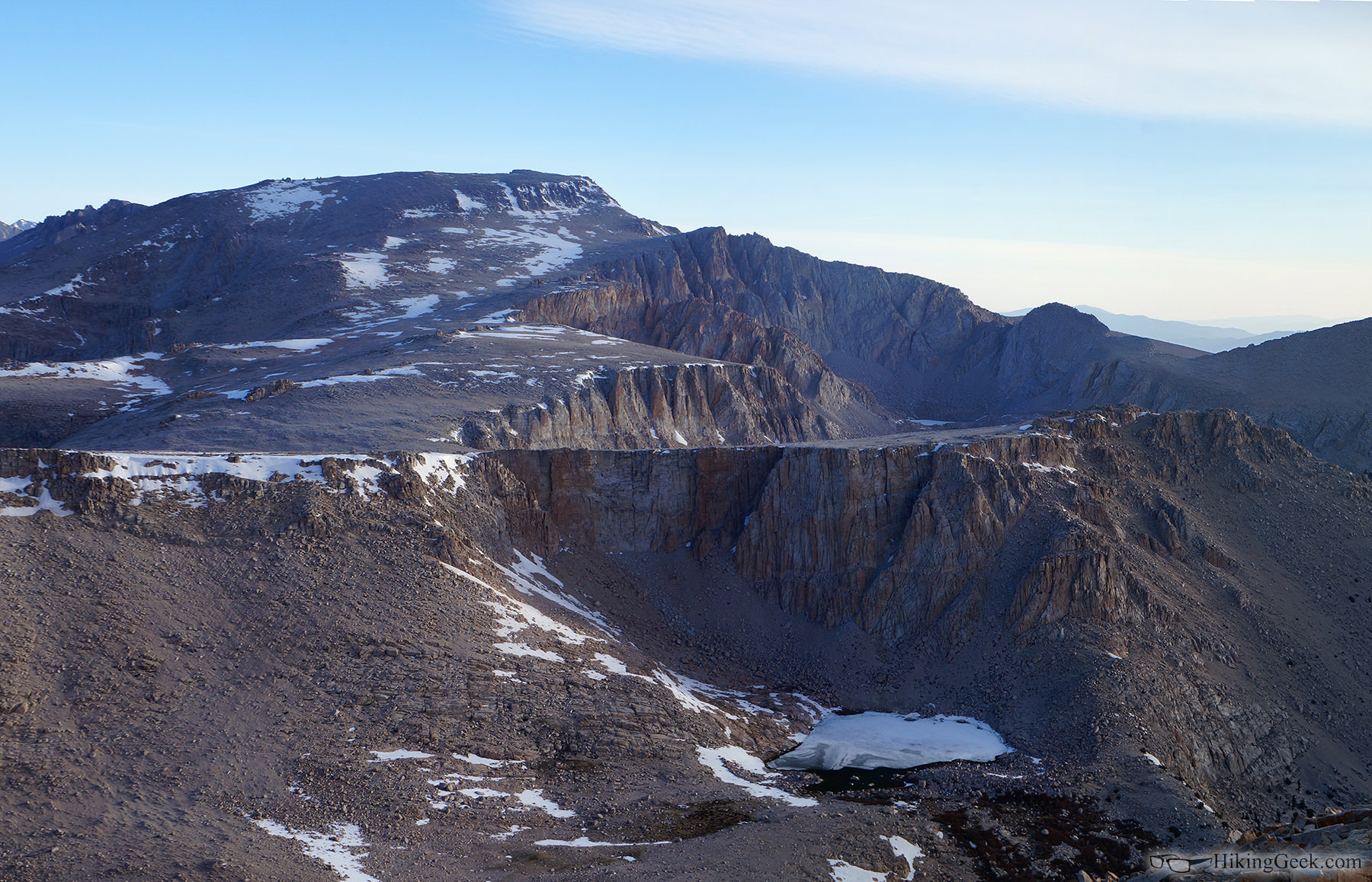
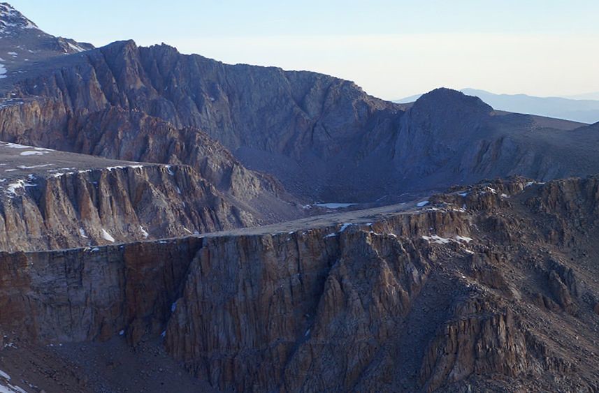
I believe this is CWL #6 (if not, please correct me), taken from Cirque Peak on 5/18:

63, that's High Lake
(Gmap4 map). NEW Army pass trail climbs the slope to the left of it. In fact, I can see two stretches of the trail on your full-size version of the picture. ...and it looks practically horizontal for a long way!
(Old) Army Pass tops out just beyond the top of that vertical cliff in the picture center. Cottonwood Lake 6 is just on the other side of the plateau with the cliff.
Edit: Looking at the map and then your picture, I think you tilted the camera just a little so the plateau looks horizontal. Actually, it climbs steadily to the right (east), as you can see from the contours on the map. And therefore, what appears to be a horizontal trail is actually ascending too.
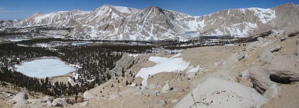
Here's a picture I took from Trail Peak of the same area. Slightly different angle and much farther away.

63, that's High Lake ... cliff.
Thanks - that all makes sense.
I can see you tilted the camera so the plateau looks horizontal...
lol... this is a pano using 4 or 5 images. It's possible I tilted the camera or photoshop distorted it. I'll have too look at the originals to see.
John,
I believe this is CWL #6 (if not, please correct me)
Looks like #6 to me....
John,
I believe this is CWL #6 (if not, please correct me)
Looks like #6 to me....
Whoa! Sharp eyes, Bob!

Obviously, I completely missed that one.