Mt Whitney Zone
Posted By: Maverick Missing Hiker & Dog Donner Summit 5/16 - 05/17/16 08:40 PM
Quote:

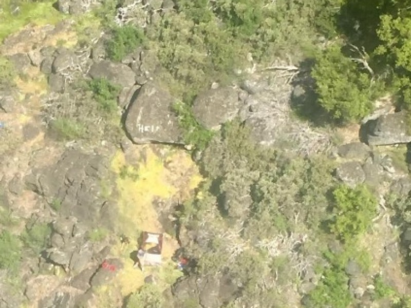
The Placer County Sheriff's Office is conducting a search and rescue operation near Donner Summit for a hiker and his dog who did not return home as planned on Monday.

The Department says if anyone was hiking in the Loch Leven area, near Hampshire Rocks Road, on Sunday or Monday, and saw a young man named Cody Michael and his German Shepherd, please call the Sheriff's Office at (530) 886-5375.

Cody, is from Rocklin, and texted this photo to his family Monday morning, and he said he would be leaving the area by noon. They have not heard from his since.

He is 23-years-old, stands 5-feet, 10-inches tall, and weighs 175 pounds. He has brown hair and green eyes. He was last seen wearing the clothes in the photo. His vehicle was found at the trailhead
.

http://kfbk.iheart.com/articles/kfbk-new.../#ixzz48wnavYTi
Posted By: Maverick Re: Missing Hiker & Dog Donner Summit 5/16 - 05/19/16 06:17 PM

Hiker and dog found: http://www.kcra.com/news/local-news/news...county/39629436
Posted By: Steve C Re: Missing Hiker & Dog Donner Summit 5/16 - 05/19/16 07:49 PM
Glad he's ok! Would sure like to read a full report -- was he lost, or was there a miscommunication on his planned return.
Posted By: RichardK Re: Missing Hiker & Dog Donner Summit 5/16 - 05/20/16 02:04 PM
The news report says he got lost. If he had spend a hundred bucks on a GPS, he would have known where he was.
Posted By: Steve C Re: Missing Hiker & Dog Donner Summit 5/16 - 05/20/16 03:50 PM
I have a GPS. Those things are really hard to learn how to use, and can be pretty expensive too, to load the proper maps.

But I looked up the area on the map where he was found. He was only several miles from the road.

Here's a followup article with a picture of his duct-tape "help" sign:

Posted By: RichardK Re: Missing Hiker & Dog Donner Summit 5/16 - 05/21/16 02:01 AM
A Garmin Etrex 10 can be had at Sports Authority for $88. How expensive is that compared to your life? It lacks fancy maps, but can still report your latitude and longitude to an accuracy of 20 feet or better with a half way decent view of the sky. Mark those coordinates on the paper map you should always have and you know exactly where you are. The key to ease of use is practice and it doesn't have to be on the trail. Get the topo map for your neighborhood (free from www.caltopo.com) and practice while walking around the block. It will soon be second nature.
© WhitneyZone Message Board