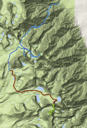
Okay, after reading your suggestions and digging up some gps tracks from various sources (the blue section) and eyeballing a satellite picture between what I think is Rockwell Pass (it's not named on any of my maps) and Mt Russell (red section), I've put together a possible route.
Exit via the MR or WT.
The trail between Mt Russell and Mt Whitney (green section) I didn't have a GPS track, but some maps showing people going between there in that rough track.
Is that a possibly good route? (particularly the red and green sections since I couldn't find any GPS downloads that corresponded to those hikes)