|
0 members (),
476
guests, and
188
robots. |
|
Key:
Admin,
Global Mod,
Mod
|
|
 Old Trail - Trailhead
|
Joined: Aug 2010
Posts: 511
|
OP

Joined: Aug 2010
Posts: 511 |
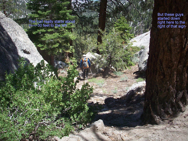
I figure this deserves its own thread so that the information isn't lost in other threads and also so that other threads aren't cluttered with the information. First, an overview of the old trail, google earth style: 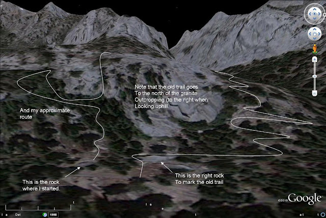 and then from actual ground level photos. 
|
|
|
Re: Old Trail - Trailhead
|
Joined: Sep 2009
Posts: 1,261
|
|
Joined: Sep 2009
Posts: 1,261 |
Ahh, yes -- I remember that rock! When we came apon that rock, Doug, Sr. took the biggest UPhill stride I have ever seen and walked up and over that rock(I hesitated before following -- I was sure that gravity was not on my side -- but followed anyway .....later, I learned that it was somewhat of a skill test that he puts newbies through)
The body betrays and the weather conspires, hopefully, not on the same day. 
|
|
|
Re: Old Trail - Trailhead
|
Joined: Sep 2009
Posts: 8,538 Likes: 107
|
|
Joined: Sep 2009
Posts: 8,538 Likes: 107 |
Here's Bob R's map of the Old Trail. The blue line is the MMWT (Main Mt Whitney Trail), starting at Whitney Portal. The Red line is the old foot-trail. Its start can be found by walking west past the Whitney Portal Store almost to the point where it loops around and down to the parking area below the store. 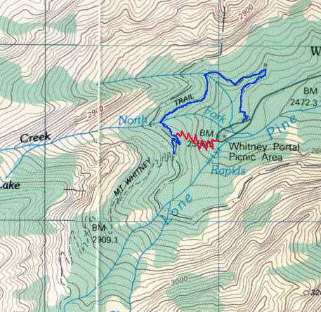
|
|
|
Re: Old Trail - Trailhead
|
Joined: Sep 2009
Posts: 8,538 Likes: 107
|
|
Joined: Sep 2009
Posts: 8,538 Likes: 107 |
Here's a satellite view picture (Google satellite view with the help of CalTopo {-Link-} with the old trail drawn onto it as best as I can. Where there are gaps, the trail is actually there, I just can't see it in the satellite view. Click on the image for a full-size view. 
|
|
|
Re: Old Trail - Trailhead
|
Joined: Sep 2009
Posts: 1,253
|
|
Joined: Sep 2009
Posts: 1,253 |
I use it on the way down. It cuts 5 to 10 minutes off your time. Obviously, it has not been maintained in decades.
|
|
|
Re: Old Trail - Trailhead
|
Joined: Apr 2011
Posts: 4
|
|
Joined: Apr 2011
Posts: 4 |
I've been down that trail (last year) and the description above is great when starting at the parking lot. However, can someone refresh my memory as to where the turn off is when coming down? I want to say it's close to a sign.
|
|
|
Re: Old Trail - Trailhead
|
Joined: Nov 2009
Posts: 567
|
|
Joined: Nov 2009
Posts: 567 |
I think it's right past the John Muir Wilderness sign on the way down. If you aren't looking for it, you'll miss it. BUT, though you avoid the water, that trail is pretty steep and not maintained. At the end of a hike, you really need to watch yourself.
 "Turtles, Frogs & other Environmental Sculpture" www.quillansculpturegallery.comtwitter: @josephquillan If less is more, imagine how much more, more is -Frasier
|
|
|
Re: Old Trail - Trailhead
|
Joined: Aug 2010
Posts: 511
|
|
OP
Joined: Aug 2010
Posts: 511 |
|
|
|
Re: Old Trail - Trailhead
|
Joined: Aug 2010
Posts: 511
|
|
OP
Joined: Aug 2010
Posts: 511 |
in light of the flash flood action this weekend, it's probably not a bad idea to always know where the alternate trails are located so as to avoid swollen rivers.
bump
|
|
|
Re: Old Trail - Trailhead
|
Joined: Sep 2009
Posts: 660
|
|
Joined: Sep 2009
Posts: 660 |
Great detail and description of the old trail. I kinda of knew where everyone was talking about but this makes it clear as a bell.
Thanks tdz
|
|
|
Re: Old Trail - Trailhead
|
Joined: Aug 2011
Posts: 2
|
|
Joined: Aug 2011
Posts: 2 |
Hi,
I have used this trail for the last 5 years, since I heard about it. This is a great short cut and a good trail. I think this is used by the rangers.
We have had some strange looks when we take pictures at the "Portal trail" sign then hop back in the truck and drive around the corner.
On the turn around the pond, just before the parking lot, look for a very large angular rock,(this is due west of the pond), walk behind it to find the trail. Many switchbacks and you end up at the first turn above Lone Pine Creek.
This trail took me awhile to find and I tried several times from the top, but was afraid I would walk down the wrong trail. So I looked for it from the bottom and finally found it.
Good luck,
Bill
|
|
|
Re: Old Trail - Trailhead
|
Joined: Jun 2010
Posts: 319
|
|
Joined: Jun 2010
Posts: 319 |
tdtz,
Based on your ground level photo, I was able to fine the old trail when I was at the portal a couple of weeks ago. The line you drew to indicate the trail goes around the big rock was a big help to me.
Thanks for posting and for sharing the SPOT track. I have hiked many a similar trail over the years.
|
|
|
Re: Old Trail - Trailhead
|
Joined: Aug 2010
Posts: 511
|
|
OP
Joined: Aug 2010
Posts: 511 |
|
|
|
Re: Old Trail - Trailhead
|
Joined: Sep 2009
Posts: 8,538 Likes: 107
|
|
Joined: Sep 2009
Posts: 8,538 Likes: 107 |
The picture above from tdtz somehow does not give you a good perspective of the size of that rock. Here's his picture: And one of the same rock with someone standing beside it:  That rock is huge -- as big as the Portal Store! This picture taken FROM the pavement of the road. Here is a picture of the trailhead sign, 1964, from Paul W. 
|
|
|
Re: Old Trail - Trailhead
|
Joined: Aug 2010
Posts: 511
|
|
OP
Joined: Aug 2010
Posts: 511 |
Wow, that really does give it some perspective.
|
|
|
Re: Old Trail - Trailhead
|
Joined: Sep 2009
Posts: 8,538 Likes: 107
|
|
Joined: Sep 2009
Posts: 8,538 Likes: 107 |
I hiked up the old trail, counting the switchbacks. There are about 30. Here is the upper end of the old trail, where it connects to the Main Trail.

This point is 30 paces (left-right is one pace) from the North Fork Lone Pine Creek crossing.
Looking toward the North Fork Lone Pine creek:

And fifteen paces from the Wilderness signs:

|
|
|
Re: Old Trail - Trailhead
|
Joined: Sep 2009
Posts: 8,538 Likes: 107
|
|
Joined: Sep 2009
Posts: 8,538 Likes: 107 |
There were three trees blown down over the old trail.
This one's root mass blocks the trail, but is easy to get by. Those roots are 8 feet high!

This one and a smaller one on the next switchback up were cleared by the end of the day:

|
|
|
Re: Old Trail - Trailhead
|
Joined: Apr 2012
Posts: 579 Likes: 3
|
|
Joined: Apr 2012
Posts: 579 Likes: 3 |
Steve,
What do you estimate the old trail saves you - distance and time? Do you miss the creek crossing? Also, are there any down sides to the old trail?
Thanks!
Last edited by John Sims; 05/28/12 07:25 AM.
|
|
|
Re: Old Trail - Trailhead
|
Joined: Sep 2009
Posts: 8,538 Likes: 107
|
|
Joined: Sep 2009
Posts: 8,538 Likes: 107 |
I don't know on saving time. From the clock time on the pictures I took, it took me about 25 minutes to walk from the main trailhead, past the store, up the old trail to the main trail. I was carrying a 24 lb pack, and I stopped to take pictures of the several fallen trees.
Maybe someone else can measure and post their time up the Main Trail to the North Fork crossing. I don't think it saves much, since you are still climbing the exact same elevation, and the 30 switchbacks cover a lot of distance.
I don't think there is any down-side to using the old trail, only it may be slightly steeper. It is a nice variation.
And it hits the main trail just AFTER it crosses the North Fork on the way up.
Edit: Got this via PM (private message -- that blinking flag at the top of the page)
The old trail is 0.3 mile shorter than the main trail. But since you have to walk at least 0.1 mile past the store to the old trail, it is only .2 shorter.
Last edited by Steve C; 05/28/12 08:31 PM.
|
|
|
Re: Old Trail - Trailhead
|
Joined: Sep 2009
Posts: 695
|
|
Joined: Sep 2009
Posts: 695 |
Given the steepness of the Old Trail, the only real advantage is when you are returning to the Portal and going down the trail. I don't see any advantage in going up it when you are heading up the trail at the beginning of your hike. p1 CaT
If future generations are to remember us with gratitude rather than contempt, we must leave them more than the miracle of technology. We must leave them a glimpse of the world as it was in the beginning, not just after we got through with it. - Lyndon Johnson, on signing the Wilderness Act into law (1964)
|
|
|
Re: Old Trail - Trailhead
|
Joined: Nov 2009
Posts: 1,256 Likes: 2
|
|
Joined: Nov 2009
Posts: 1,256 Likes: 2 |
And it hits the main trail just AFTER it crosses the North Fork on the way up. That's really the primary benefit, especially on the return leg if you have a heavy pack and you're tired. The North Fork will tend to flow heavier later in the day with accelerated melt. In heavy snow years, like last year, the rock hops across the stream can flood making crossing with a heavy pack and fatigued legs a real pain. Much easier to just zip down the Old Trail and avoid the crossing altogether. p2
|
|
|
Re: Old Trail - Trailhead
|
Joined: Sep 2009
Posts: 1,253
|
|
Joined: Sep 2009
Posts: 1,253 |
Most importantly it gets you to the beer about 5 to 10 minutes sooner.
|
|
|
Re: Old Trail - Trailhead
|
Joined: Sep 2009
Posts: 130
|
|
Joined: Sep 2009
Posts: 130 |
Given the steepness of the Old Trail, the only real advantage is when you are returning to the Portal and going down the trail. I don't see any advantage in going up it when you are heading up the trail at the beginning of your hike.
CaT I agree. We used it one year when the creek levels were high to avoid the crossings. Otherwise, you do not really save that much distance since you still have to walk to and from the trailhead. You just get to flat pavement quicker going down the old trail.
|
|
|
Re: Old Trail - Trailhead
|
Joined: Nov 2009
Posts: 1,256 Likes: 2
|
|
Joined: Nov 2009
Posts: 1,256 Likes: 2 |
Bump.
Since this topic came up on another thread, I thought I'd add an episode from my Whitney hike last year. We were descending and sort of picked up a solo JMT hiker into our group just past Mirror Lake. This guy was completely burned out, at the end of his endurance, and still carrying a super-heavy pack. Very unsteady on his feet. This was also just after the monster deluge that had inundated the mountain and wrecked the Portal parking lot. This guy had some familiarity with the trail and knew the longest water crossing was coming up at the North Fork, and was fretting about it due to his pack weight and fatigue. He also knew that it would be flowing much heavier than normal due to the storms. He clearly did not like water crossings.
When we got to the Old Trail junction, I asked him if he'd like to completely bypass the North Fork crossing headache. He looked at me like I was crazy, but as we started down the Old Trail he fell in behind us. He did have a little difficulty negotiating the un-maintained, rocky trail, but when we quickly reached the Portal lot the look of relief and amazement on his face spoke volumes.
"You can bet I'm gonna remember that shortcut!", he said.
|
|
|
Re: Old Trail - Trailhead
|
Joined: Feb 2011
Posts: 1,572
|
|
Joined: Feb 2011
Posts: 1,572 |
It probably saved a couple of lives in 2011 during a similar deluge, when staff from the Portal Store went up in the storm and escorted hikers down it to avoid a raging North Fork.
Wherever you go, there you are. SPOTMe!
|
|
|
Re: Old Trail - Trailhead
|
Joined: Nov 2009
Posts: 1,256 Likes: 2
|
|
Joined: Nov 2009
Posts: 1,256 Likes: 2 |
I remember that - we had just left about a week before. Mid summer can be ugly in the Southern Siera with the unpredictable monsoon effect.
Outside of a hurricane, and a few monster t-storms we'll see in the south during spring/summer, I've never witnessed skies as angry as what I saw around the Portal last mid-July. I remember Doug telling us to absolutely, positively go no further than Outpost Camp if they didn't clear. How right he was.
|
|
|
Re: Old Trail - Trailhead
|
Joined: Jun 2016
Posts: 10
|
|
Joined: Jun 2016
Posts: 10 |
Hi all,
Is there a reference picture which shows the start of old trail near Whitney Portal Store?
Is the rock clearly visible from the portal store?
Thanks,
Amit
|
|
|
Re: Old Trail - Trailhead
|
Joined: Sep 2009
Posts: 8,538 Likes: 107
|
|
Joined: Sep 2009
Posts: 8,538 Likes: 107 |
Hi all,
Is there a reference picture which shows the start of old trail near Whitney Portal Store?
Is the rock clearly visible from the portal store?
Thanks,
Amit Click on the first page of this thread. When you see the pictures of the Big Rock, the portal store is about 50 yards back along the road, behind the photographer. Just walk the road past the store (about 50 yards), and the big rock (it's huuuge!) will be on the right, as the road loops around the pond to head back to the main trail head.
|
|
|
Re: Old Trail - Trailhead
|
Joined: Nov 2009
Posts: 1,256 Likes: 2
|
|
Joined: Nov 2009
Posts: 1,256 Likes: 2 |
Hi all,
Is there a reference picture which shows the start of old trail near Whitney Portal Store?
Is the rock clearly visible from the portal store?
Thanks,
Amit Amit, just be aware that this is an unmaintained trail and is very gnarly and steep compared to the current MWMT. If you're carrying heavy weight, it can be a real slog on the ascent.
|
|
|
Re: Old Trail - Trailhead
|
Joined: Jul 2017
Posts: 41
|
|
Joined: Jul 2017
Posts: 41 |
I agree with Bulldog. That old trail has places with loose sand over slick rock, so you can take a bad step and really bust your ass.
The first year that I ever went up, it was 1976. There was a pack station there. I didn't have any problem finding the old trail, because I simply followed my nose. There was a lot of animal "debris" then. Soon after that, the "new" trailhead sprang up. The new trail is more gradual and a lot safer, but only if the north fork of lone pine creek is reasonable. If you go up the old trail, it intersects just above the creek crossing.
The big rock is the biggest rock at the top end of the Whitney Portal loop.
|
|
|
Re: Old Trail - Trailhead
|
Joined: Aug 2019
Posts: 3
|
|
Joined: Aug 2019
Posts: 3 |
Bumping the thread - went up this way yesterday. It is intact and IMO comparably maintained relative to the main trail.
It is 0.65 miles from the "start" to the junction of the main trail, vs. about 0.95 from the actual start to the same point.
So you save 0.3 miles x2, and another benefit is if you are starting super early, parking is empty around the Old Trail start whereas it has already started to fill up around the actual start. I was able to park right next to the start.
|
|
|
|
|