First, thanks to all that provided the much needed beta/advice on how to do this hike (Steve and 2600fromatari in particular). It was difficult enough "sort of" knowing where I was going. Without your advice, I might still be out there; wandering in the wilderness (isn't there some biblical expression about that?).
In any case, I spent two nights up at Mammoth as part of the acclimatization process. I had one day to visit Red's Meadow, the Devils Post pile, etc… Really a beautiful part of the Sierras. Then, on Wed. morning I drove down to Lone Pine (100 miles) to pick up my permit.
Then I drove up to the Portal for more time at altitude, and to preview the start of the MR. Since I would be starting before sunrise on Thursday I wanted to be familiar with the route, at least as far as the E Ledges. I tried to find the "north" route, but ended up crossing back to the south side of the creek, and doing a bit of bushwhacking to get back on the trail. I doubt this delayed me much, but it established that I should just stick to the "standard" route, rather than trying the "north" route. Time to reach the Ledges from the Portal was still less than one hour, even with the diversion. I did cross the ledges, and felt comfortable doing that, so felt as prepared as I could be for the next day's hike.
I left the Portal at 4:45 AM, and proceeded up the trail, turning right at the North Fork of Lone Pine Creek, and on up the hill.
My first lesson:
• A headlamp really only illuminates the nearest 10' or so. This means you can follow a false trail for a bit before realizing it. For other first timers, stay alert to possible false trails. They seem to be the result of high water periods, where the creek finds new ways down the hill, which leave washed out areas that look much the same as the trail. I did follow one of these for 20 or 30 yards, and had to backtrack accordingly. When I went back and found my error, it occurred to me that the false trail looked more inviting than the "real" trail.
At the ledges at 6:00 AM, I stopped to put my walking sticks away. Actually, I do not recommend using these for the Mountaineer's route. There are enough areas where you want to use your hands that the Walking Sticks are more of an encumbrance than a help (at least that is how it was for me). I did not take them off my back pack until starting down the Main Trail if that is any indicator.
So, a bit of good fortune. As I was putting my Walking Sticks away another hiker appeared. Carlos was also a "first timer" for the MR, and after crossing the ledges together we decided to hike together. This was a big help for me (and I think for Carlos as well). We both had beta from various web sites, but having one another's view was very helpful finding the way.
So, my next two observations (mainly for others doing their first hikes)
• As mentioned on many web sites: This route is STEEP. I'm not sure I would say it is harder than the Main Trail, but it is more intense, and requires greater exertion. You will be breathing deeply.
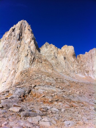
• Even though the resources of this board are great, and no matter how many videos and pictures you viewed, it will not look the same when you are there. The photos just do not capture the scale of the Sierras. All around you walls rise steeply up, and the perspective is very different than seen in the photos and videos. At least that was my observation. One of my pictures is very similar to one of Steve's where he shows how to access the slabs. Yet, when I took that photo, I did not notice that the view was the same as in Steve's photo.
So having crossed the ledges (really no big deal, but I do not recommend doing this in the dark) Carlos and I started up against the wall on our way to LBSL. Here the route was easy to follow, and we were at LBSL at about 6:15 AM (Just after Sun rise).
We ended up on the slabs without any issues and made good time to the top of the slabs. It is possible to go for a while without seeing any cairns, but keep climbing, and you will soon find one. The hike on to Iceberg Lake is tiring (did I say this route is STEEP?), but the final climb up past the last seep is fun. Finally you come over a small rise, and there the lake is! Time for lunch, and a break.
Here, the view of Mt. Whitney is great. But it is not the same view as shown by most "route" photos (please see my photo in the
Picture Gallery).
As everyone says, stay left, but from this vantage point, that is really "straight ahead". Again we were fortunate, because just as we were finishing lunch a runner passed by. No joke, wearing a tank top, shorts, and trail running shoes. In any case, we got a good look and his initial route, which we were comfortable, was an efficient one.
So, onward up the chute.
My fourth observation - for climbing to the Notch:
• There are no right or wrong routes. Certainly one might be better or worse, but as Moose Tracks said: "Bottom line, just look at everything, see what feels right, and go for it. Everyone here can say til the cows come home just how to "get up it" but you don't know exactly what to do until you get there."
• Or as I was advised by 2600fromatari: You may see a few cairns going up, a faint path here or there. Do not worry if you don't, or if you lose it. Head directly up this thing. If there is any part you don't feel comfortable on, there's always an alternate path somewhere to the left or right.
The climb up the chute is tiring (Did I say that this route is STEEP?). Also, as others have said, you cannot completely avoid the scree and loose rock, but you can climb smartly, finding as much solid stone to walk on or hold on to as you can.
Finally, the final 400.
For me, this was actually the most fun part of the hike. Solid rock to stand on and to hold on to! There are some modestly difficult moves. The first move up the first chute requires some upper body strength, and flexibility, but not prohibitively so. Just look and see what feels right to you. There are many possibilities, and you will just have to use your own judgment. Having said that, we took the most common advice, and stayed to the left of the first chute. We happened to be very near the top when two climbers started coming down. They had just done the East Face, so we felt their route was one based on some intelligence, so we just reversed it. I think it is different than any of those shown on the pictures showing various routes up the final 400 (Bob Rockwell image showing various routes), but worked for us.
EUREKA! Topped out in just less than 8 hours. Twenty five minutes on top, basking in our glory, we started down. Carlos went back down the MR, but I opted to take the long way down the Main Trail. Coincidently, we both arrived at the portal at the same time. I was going as fast as my feet would allow (some pain here), while Carlos was spending some time taking more pictures. Total time was just under 14 hours.
For clarity you may want to see my pictures in the
Picture Gallery.
This was my second summit this year. The Main Trail on June 20th and the Mountaineer's route on Sept. 20th. I found the MR far more rewarding, but not without some pain


