I know I have not finished my report from my 2012 trip but I started this one anyway. My plan for this report is to do it by sections between resupply. My maps wont completely work for this idea because other than the first one the rest are marked by week.
MAP (
large)
IMAGES Here I go again...
June 1st 2013 - I wake up only 30 minutes before I was supposed to be walking out the door so immediately rush mode sets in. No time to stop and consider what I am setting out to do. And what I was planning to do was 5 months in the wilderness hiking for hundreds of miles facing dangers every day. But hell I had done this before so for now it was business as usual.
Once I had everything loaded up and was ready to leave I stopped and looked at my room and it's contents trying to grasp the idea that I would not walk through these doors again for 5 months and after being injured badly the year before the idea was more real than ever that I may not ever come back again. I walked out of the house without the lightest care if I ever did come back...
The drive like every other year was hot and desolate in the summer atmosphere. Chris had taken the doors off his Jeep so it was also a noisy one. After taking many odd sorts of routes we finally arrived at Cherry Lake which displayed a sign saying that wilderness permits required for over night travel and that they could be gotten some where along 120. That's great I thought as it now was obvious I had not done my homework. I had thought I could get a permit at the Ranger station at Lake Eleanor. At this point my two options were to either hike in illegally without a permit or add another 2 hours onto this drive which was not an option considering Chris was driving all the way home the same day. So I shrugged and said "oh well I will just get one the first chance I get".
We pressed on towards Eleanor and the road became a rougher dirt road with plenty of debris on it from the winter months. We took a couple wrong turns in our attempt to even find the lake which was not very well marked. When we finally arrived at the trail head or more accurately put a locked gate not allowing us to drive to the trail head I thought to myself this is it? This is the trail head? No bathroom, no trash cans, nothing more than a primitive location baking in the oppressive summer heat. This was proving to be a rather unceremonious beginning to such a trip.
After taking a mandatory
starting photo Chris drove off with the fading sound of automobiles and any other sound of society to be replaced with the sounds of the peaceful forest.
I began in over whelmed with emotion of being back out in the wild, almost to the point of tears. However this environment was different. I describe it as not being in my element. The heat was extremely oppressive at this low altitude, the over all look is completely different and it didn't even smell the same. I did not feel the same connection with being here. This feeling would continue until I found myself at higher altitude.
I made my way down the road and across the dam. I thought about asking a Ranger at the station here to write me some sort of temporary permit in case I run into any Rangers in the backcountry but there were so signs of life. I picked up the trail and fought my way
along it . My god it's hot and this pack is heavy I thought as I periodically sat on rocks to rest. When I reached Frog Creek I was surprised at how nice of a camping area it was. Nicely shaded in Jeffery Pines with even a BBQ grill to use. I realized that if Chris had hiked in for the first night like I tried to get him to do instead of driving back the same day we would have camped here. I however decided I wanted to get as close to the inlet as I could. Ideally at it so pushing on I came to my first ford of the trip which proved to be heaven after the hot slog. The creek was no more than knee deep so it was no problem to cross. This brief morale lifter did not last long as the terrain from here quickly beings to shift into over grown Manzanita among one micro cliff after another. So after climbing, pushing and scraping my way through the mess I came to a small camp site with a fire pit but decided to keep going. After a bit I came to another spot that could be used with a little bit of work but at first I decided to push on until I stopped and considered the reality here. This whole area was a mess of rough granite and it's 6:30PM. How far will I have to go before I even have a chance at finding a camp? So I turned back and set up.
As I sat
in camp I was just dumb founded you could say with the whole situation. It's day one! I kept thinking to myself. After everything I went through the year before and after being back in Bakersfield for 8 months here I sit again back in the wild on day one! I kept saying I know I will blink my eyes and it will be day 100 but for now here I am! And a nice
sunset to go with it.
After leaving my camp in the morning I didn't get too far before the terrain began getting worse on me. Off into horrible brush and rolling micro cliffs until I found myself on hill sides so steep you could hardly navigate them. It was some where in this point where the thoughts of turning back began playing in my head. I realized that if Chris had done this section with me which he originally was planning to that we would have turned back for sure. The only reason I didn't turn back is because the thought of going back through everything I had already done was so horrible so I just kept thinking that maybe it would get better. Wishful thinking but foolish hope in the end. As I pushed through the horrible brush I finally turned the corner putting me on the Eastern side of the lake in what should be the final push to the inlet but in my way was nothing but a mix of large cliffs which forced me to keep climbing higher on them. At one point I
looked down and it caught me off guard to see a couple in a kayak coming my way. They probably were wondering what this fool is doing up there!
Pushing on I was forced to keep doing climbing moves that were straight scary. Far outside my comfort zone and pushing through horrible thick bushes including Manzanita that was over my head up vertical sections of rocks and 70 degree hill sides. THE HORROR!!! OH FUCKING HELL THE HORROR!!! I thought. What have I got myself into!!! ARRRGGGG!!! I am normally crazy enough to push knowingly off into this sort of crap but for day 2 in horrible heat this was all just too much. I sat on a rock above a cliff and took a break. Flashing back I had forgotten to buy a second bottle so I could have 2 liters of water with me. Chris luckily had a water bottle he had bought for the ride which he gave me at the trail head saving me from dehydration especially when I go for a summit bid. As I sat and drank water out of this bottle the small cap slipped from my hand and tumbled down over the cliff side. I watched it fall down in almost slow motion and completely emotionless. Then I burst out laughing at this ridiculous turn of events. Well back to a single liter again.
After more horrible misery and finally nearing the outlet I was forced up friction climbing a solid granite wall that was so steep I would have never even attempted to climb down it. I found myself at the inlet after about 4 and a half hours to travel less than 1 mile. But wait I was not at the inlet itself but I was high above it. I wanted to be down near the water as I could tell there were allot of cool cascades but there was no way down. Nothing but cliffs. It was at this point that I knew there was no going back no matter what. I am going up this creek do or die! My only hope now lay in the idea that it would get better up the creek. Did it get better? Nope! Nothing but non stop over grown brush with complex micro cliff terrain. Every time I would try to get a break and change my current route placement it wouldn't pay off. I kept jumping from creek level back higher up and on it went all day long in just scorching heat. Finally I felt like I was over heating to the point of heat stroke so I went down to this
beautiful pool and relaxed in the shade where I saw my first Western Pond Turtle so over all it was a good break. The rest of the day never did let up on difficulty. Even when
the terrain was not as brushy it was endless rolling micro cliffs and sometimes high class 3 climbing and over all misery until I reached a sandy area where I set up camp giving up any hope of reaching Edith Lake today which was the original plan. As I lay in bed I firmly kept the mental note that I will never EVER climb up this creek again!
Continuing up Kendrick creek was just more of the same. Steady misery without much to say about most of the creek other than to be expected there were many beautiful
cascade displays along the way. Also a special place to note is when you reach the
little lake along the river and hike around the Southern side of it you pass through an area that displays one of the most beautiful Aspen forests I have ever seen. When not in this you are in a huge open area completely over grown with Ferns that are 6 feet tall. This is also mixed with giant tuber style plants and some loose beautiful Willows. It was like climbing through a thick yet beautiful jungle. Although a jungle with 110% humidity. I have never seen anything like that small spot anywhere before or after.
So after a long day of more misery I finally find myself closing in on Edith Lake. You would think at this point it would let up and become easier to travel but hell no it doesn't. When I'm a
half mile out from the lake that is still an hour of travel with my feet killing me and I was all cut up from the jungle. One of the final pushes to Edith I found myself on a giant technical talus field completely over grown with brush. Basically some of the worst possible terrain. When I finally reached Edith I was a bit dismayed at the lack of camping here. I first found an area that seemed to be a good place to camp but the
shore line was completely over grown with brush and had no access to water of any kind. Finally I settle on
a camp that requires you to climb way down the hill with a single tiny access point to the water. So as I put it in my audio journal "it took me 2 days to do what I thought would take one and I am beat to shit".
Leaving my camp here was still a bit slow going. Getting around the lake took me about an hour until I reached the granite faces of the far shore. Unfortunately the water level of the lake was too high in order to get easily on the rock so climbing up nearly vertical cracks in the rocks was the only way. From here it was fairly
easy terrain all the way to the base of the
large fall which was a pretty impressive sight. Long before I began this hike I was a bit worried about getting up this fall and what the granite would be like on top. Luckily I caught a break and found a small channel on the left side of all the brush which made getting to the top no trouble at all and at this point you leave all the brush and complex micro cliff terrain behind completely. Nothing but
typical beautiful Sierra travel from here! Pushing on up the beautiful creek and reaching another hill side of
cascades the rain began falling. Nothing too crazy but just a steady rain. My goal for today was to camp at Fawn Lake but as I got closer to it I realized the only option would be to ford the river as this entire area was nothing more than a raging torrent. I continued along not exactly sure where the lake was until I saw a location that I could set up and just settled on it. While climbing up on a rock by my camp and admiring that the river was so high that it was just calm on the surface I could actually see Fawn Lake. It was a quite odd little lake which the inlet was also the outlet at the same time. Sort of like a single flood area for the river. It certainly could not be reached from here but only about 100 yards from my camp was an actual campsite with a fire pit. Just another place to add to the list of setting up and finding a better place to camp very close by.
Setting out in the brisk morning I finally found myself high enough to cross the occasional patch of snow. I began up the South side of the river but as I got higher I noticed that the creek was much smaller in size and that it most likely had branched off so I set out into the water and had to ford 3 branches of the creek before I was able to climb the final slopes up to
Twin Lakes 2 days behind my planned schedule. I began around the Northern shore and took note of a camp or two but because the lower
Twin Lake is about a mile long I wanted to camp near the inlet so I kept on going in sort of a death march fashion. I only had one bottle of water which had run out but I did not stop due to the fact that I was getting so close to camp so I just kept pushing on getting more tired and dehydrated. As I neared the outlet I took note of two Bald Eagles flying about letting me know that plenty of them were in this general area. The camping however proved to be non existent along this entire shore line. When I got to the inlet it was no better off. Just a swampy mess. I took note of a single location that I could tell once had a fire pit but it was not legal and just horrible all around so I just said to hell with this and began pushing on to the upper lake. Although I found bits of the trail leading up it was so indistinct that it was far less effort to just go cross country. Along the way one of the Bald Eagles zipped through the trees and not to much further an Osprey was also darting about. By the time I reached the outlet of the
upper lake I was quite beat. My shoulders were killing me and I was very dehydrated. I took note of a horrible camp with a giant fire pit and kept going until I found another location that was just ok. Hoping for something better for a 3 night stay I set out along the
Eastern shore looking for anything without luck. Finally I found a location that was a really nice place to camp but it was too close to water and illegal. I could tell that it had once had fire pits. I actually debated on staying there but I decided I didn't want to be that guy to give the Rangers more work and said the hell with it! I am going back to that other camp which honestly after some repair to the fire pit and adjustments to the location for a tent it turned out to be a great place to camp so home sweet home for the next 3 nights.
The following day was nothing more than a layover. Spent all day being lazy with only a bit of a hike around
the lake where I found an ok camp site used by packers.
On this summit day I set out around the Eastern shore once again and began angling up the hill side which at times was a bit steep but over all easy terrain until you reach a leveled out area with allot of
marsh . From here I began climbing up the rocks towards the peak until I was only maybe 150 feet below the summit and I realized I was not climbing Bigelow Peak at all but an unnamed peak to the NW of it! I looked up and considered going to the top but for some reason the higher looking class 3 near the top made me just bail off towards Bigelow. Later I would wish I had climbed it as it's a quite prominent peak viewed from the NW.
From
this ridge it was easy class 1 walking offering some
nice views . The whole climb up Bigelow in general was a low class 2 walk up at best. I was only a bit disappointed that there was no register on the peak. It did however have the park boundary marker. After enjoying the
fine views all around for an hour or so I took a different route down back to the marsh and a bit more direct down the steep hill side towards the lake. In the middle of the forest I came across a small glass bottle with something strange in it I could not identify. It almost looked like rock but it did not sound like rock when it hit the glass. I almost thought it was some sort of scat sample. It had a strange smell coming from it so I packed it back to my camp and left it there. I'll let some other brave soul pack out the mystery jar!
After 3 peaceful days I set out along the faint trail which was still fairly easy to follow with some patchy snow here and there. The ford of Cherry Creek was no problem and then I made my way up this old road until I reached
Horse Meadow which I found to be completely stunning even with an old fence line running across it. Then it was up past
Maxwell Lake taking in what I could of this large lake from the trail and pushed up the hill. As I neared
Blackbird Lake I thought I was following the tracks of a man and woman with a dog but I saw a Coyote running around the lake so they may have been alone. The final stretch of trail down to
Emigrant Lake was heavily snow covered but did not cause any problems. When I reached the large inlet I was amazed to see about 60 fish with the smallest of them being at least 10 inches all lined up feeding. My god I thought... It's an all you can eat buffet!
I set out into the bone chilling waters which still proved to be an easy ford. When I was getting my shoes back on I was startled to look up and see a man standing at the bank. I had not seen a person in 6 days so it was a strange experience.
I made my way along
Emigrant until I stopped and ate lunch. Although this lake was perfectly nice it certainly did not strike me as being anything particularly special. Since it had been closed to camping probably from over use I was expecting more but oh well
on I go . My original itinerary was to follow an old trail down the outlet of Emigrant Lake and along the North side of Cherry Creek but I decided it would be more scenic if I went out around Buck Lakes instead so topping the small hill and going down to where I had to ford Buck Meadow Creek I had been warned the mosquitoes in
this area were bad and the people I talked to had not lied. The whole meadow area North of Buck Lake was a solid nest of the little winged demons!
Buck Lake itself however turned out to be a magnificent lake that I considered plenty worthy to come back to some day. So finally taking yet another junction and having to ford the outlet of
Buck Lake I set out on my final push to Cow Meadow Lake. When I reached the North Fork of Cherry Creek I was a bit scared at first because it looked like a chest high beast to cross. Luckily just down stream I found a mess of logs crossing a fork in the river so I never even had to get wet.
Arriving at
Cow Meadow Lake I found a nice mosquito infested camp and got set up just in time as once the last item went in the tent it began raining pretty hard. I cooked in my tent and ended my longest day so far in terms of miles.
Leaving in the morning it was a short climb up
the hill but I lost the trail a couple times especially around Letora Lake. When I reached
Huckleberry Lake I ran into the two guys which were the first I had seen in 6 days back at Emigrant Lake. I asked where they were headed but I could not make any sense of the directions they gave me. I never did see them again.
Once I had left Huckleberry Lake behind it was nothing but a miserable hike for the next hour or two through an over grown marshy mosquito hell trail. My shoulders were killing me again and not having anything but the green tunnel to stare at keeps your mind focused on your pain. Finally I came to the second ford of Cherry Creek and after you pass an
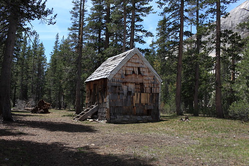
old cabin things begin to turn around. You leave the thick forest and the whole area shifts to
all granite and the mosquitoes went away. The only down side to this was that you begin losing the trail allot. I found this whole trail to be strangely designed in the way that some areas they made allot of effort to blast the crap out of the rocks and make a nice trail and then tons of other areas they did nothing and you have no trail at all. Despite this it was a fairly easy trek down river with only a few areas that require you to look sharp to find your way. I had to make two more fords of
Cherry Creek which were quite nice as the water wasn't very cold. Finally I came to the last ford of the day closing in on Lord Meadow where I saw a small water snake with a trout in it's mouth when things turned around. The mosquitoes came in on me in one of the worst displays I have ever seen. I put on all my armor layers and I just had to stand and gawk at how many there were! My entire body must have had 400 mosquitoes on it. The thought of camping in this area suddenly became a horrible thought! But something strange happened. I hiked about one quarter mile to an open area offering some ok camping and there was not a single mosquito in sight. I went down to the river and took a nice swim in water that was so mild it was just heavenly to be in. The whole night turned out to be one of the most enjoyable of this whole section.
Leaving Lord Meadow and climbing
Styx Pass was a really straight forward and easy task. I made my way to Sachse Spring in about an hour and twenty minutes and topped off my water. It wasn't too long after this that I saw something strange coming up the hill. "What the hell is that?" I thought until I realized it was a man carrying a kayak. I had no idea that it was so popular to come up this trail and launch out of Lord Meadow. I saw about 6 more Kayakers further down the trail. This first guy however I chatted it up with and he turned out to be a very experienced backpacker that did allot of cross country also. I asked him if there were any trash cans at his trail head since I had planned to dig through them in an attempt to find another water bottle since I was still stuck with only 1 liter. He said that there wasn't and was actually nice enough to give me one of his Platypus bottles which certainly saved me through the whole next section of the hike. So I kept grinding down the hill slowly returning to lower altitude. I came out at the trail head and then quickly picked up my return trail which was a bit of an old road that then goes into a beat up old trail. The only thing of real note along it is at one moment your hiking through this very dense beautiful pine forest and then you round this corner and it instantly shifts into a low altitude style oak and manzanita forest like you had walked out of a painting and into another.
So after a long grind I make my way into the backpackers camp which was completely empty. It was more primitive than I was expecting but certainly pleasant either way. I got set up and emptied my pack and began making the hike to my starting trail head where I had left my package. For the last day or two I had been trying to remember if I had left anything good in it for this dinner. I really thought that I had put a can of chili and a bag of chips in it but I didn't really want to get my hopes up because this was the second time I had ever done a resupply of this nature where I had no services of any kind. It was just pick up your package and go. When I finally get to the box and open it up what did I find inside? Nothing... Not a single extra goodie. I was actually quite angry at myself for not putting anything in there. Just another "what the hell was I thinking!?" type of moment. But it actually did not stop there. Not only did I not put anything better in it I actually did not pack a meal for this night at all! The only reason I even had a dinner to eat was because I changed my route slightly and the next section was going to be 13 days instead of 14.
Because there was no trash cans at this trail head I put all my stuff in the package and back in the bear box and left a note saying I was a long distance hiker and please drive this box out for me.
So I make my way back to camp disappointed and sorted my food while a gentle rain fell ending my first 10 days in the wild.