|
0 members (),
225
guests, and
175
robots. |
|
Key:
Admin,
Global Mod,
Mod
|
|
 Trailheads transportation
|
Joined: Aug 2014
Posts: 3
|
OP

Joined: Aug 2014
Posts: 3 |
My girlfriend and I are planning a month vacation in September to the States in which we would like to hike the Grand Teton Crest trail, the Coyote gulch, Escalante and the highlight should be the High Sierra Trail.
We will reach the Sierra Nevada by car from the east and intend to hike the trail from west to east. Because we are not able to find a way getting back from trail end to trail head we are thinking about renting another car (probably from Las Vegas) and leave it at Lone Pine Portal (returning it to Fresno after coming back).
Does someone have a better solution than renting (another) car for 10 days / would like to join us on our way back from Lone Pine towards Fresno?
cheers
Danny
|
|
|
Re: Trailheads transportation
|
Joined: Apr 2011
Posts: 101
|
|
Joined: Apr 2011
Posts: 101 |
You can get away with renting one car and parking it at the Crescent Meadows when you start HST. There is a very expensive option of taking a shuttle from Whitney Portal to Crescent meadows costing around $800/-.
Other alternative is take a taxi (to be pre-arranged) to Ridge crest (may cost around $100/-) from Whitney Portal and there rent a one way Hertz rental (Ridge Crest to Visalia) - which may cost around $50/-. Drive to Crescent meadows, pick up your original rental and return the Hertz rental in Visalia. This presumes two drivers in your party.
For taxi service in Lone Pine, there is lot of info available in these chat pages. I recently (in July 2014) did HST and was lucky in having two San Jose cousins help me out - one dropping me off at CM and one picking me up at WP. We also did the alternative 2 above a few years back and it worked out well as we both are drivers.
|
|
|
Re: Trailheads transportation
|
Joined: Aug 2014
Posts: 3
|
|
OP
Joined: Aug 2014
Posts: 3 |
Krishna,
I read what you wrote about your 2014 HST trip and made me so happy to know that I'm about to get there.
The LP to CM shuttle is indeed the expensive options (as renting a car for the whole time should probably cost about half of what you mentioned).
Second alternative sounds good. I will sure look into that. The only problem with that plan is that I'm not sure when will we finish the hike and get to LP (depends on how long will it take to get permits & how many days will the hike take). So pre-arranging the taxi might be a bit problematic.
Thank you for your reply and the detailed post about your HST experience.
cheers
|
|
|
Re: Trailheads transportation
|
Joined: Sep 2009
Posts: 8,538 Likes: 107
|
|
Joined: Sep 2009
Posts: 8,538 Likes: 107 |
Danny, the car rental from Ridge Crest is a good suggestion. There is also the Eastern Sierra Transit system that makes runs from Lone Pine to Mojave, where you could rent a car and drive to Visalia (or Fresno), too.
For maybe $150, I think you could even take a taxi from Visalia or Fresno to Crescent Meadow.
Also, Yosemite YARTS service may still be running between Mammoth Lakes, Yosemite and Merced. (But September may only be on weekends.) From Merced, AMTRAK runs to Fresno and Visalia.
Unfortunately some of the public transportation options, where you would transfer from one to the next, would require spending a night in the connecting location. So maybe the car rental and taxi options might take less time.
...Thinking more about this, you could possibly drive your primary rental car to some point on the east side and take public transportation and taxi to Crescent Meadow. For example, leave your car in Mojave, take AMTRAK from there to Visalia or Fresno, then hire a taxi to take you to Crescent Meadow. After your hike, take ESTA from Lone Pine to Mojave. Leaving your car in Mojave would remove the need to stay overnight: Arrive early, take AMTRAK and taxi to Crescent Meadow. After the hike, spend a night in Lone Pine, take the ESTA bus (MWF only) down to Mojave.
|
|
|
Re: Trailheads transportation
|
Joined: Aug 2014
Posts: 1
|
|
Joined: Aug 2014
Posts: 1 |
My name is Kurt and I live in Lone Pine. I have started shuttling people from their cars to where they want to start their hikes in the Eastern Sierra. I am retired and enjoy doing it for very reasonable rates. Send me an e-mail (w6ph@aol.com) with your phone number and a good time to call and I will get back to you to discuss your needs. Thanks.
Kurt
|
|
|
Re: Trailheads transportation
|
Joined: Oct 2009
Posts: 2,251 Likes: 1
|
|
Joined: Oct 2009
Posts: 2,251 Likes: 1 |
Kurt: welcome to the Board. First post and you have already made a contribution.
Verum audaces non gerunt indusia alba. - Ipsi dixit MCMLXXII
|
|
|
Re: Trailheads transportation
|
Joined: Aug 2014
Posts: 3
|
|
OP
Joined: Aug 2014
Posts: 3 |
Thank you guys!
cheers
Last edited by Danny B; 08/24/14 05:22 AM.
|
|
|
Re: Trailheads transportation
|
Joined: Feb 2011
Posts: 1,572
|
|
Joined: Feb 2011
Posts: 1,572 |
Whatever you do, do not get on this bus: it obviously has directions reversed: 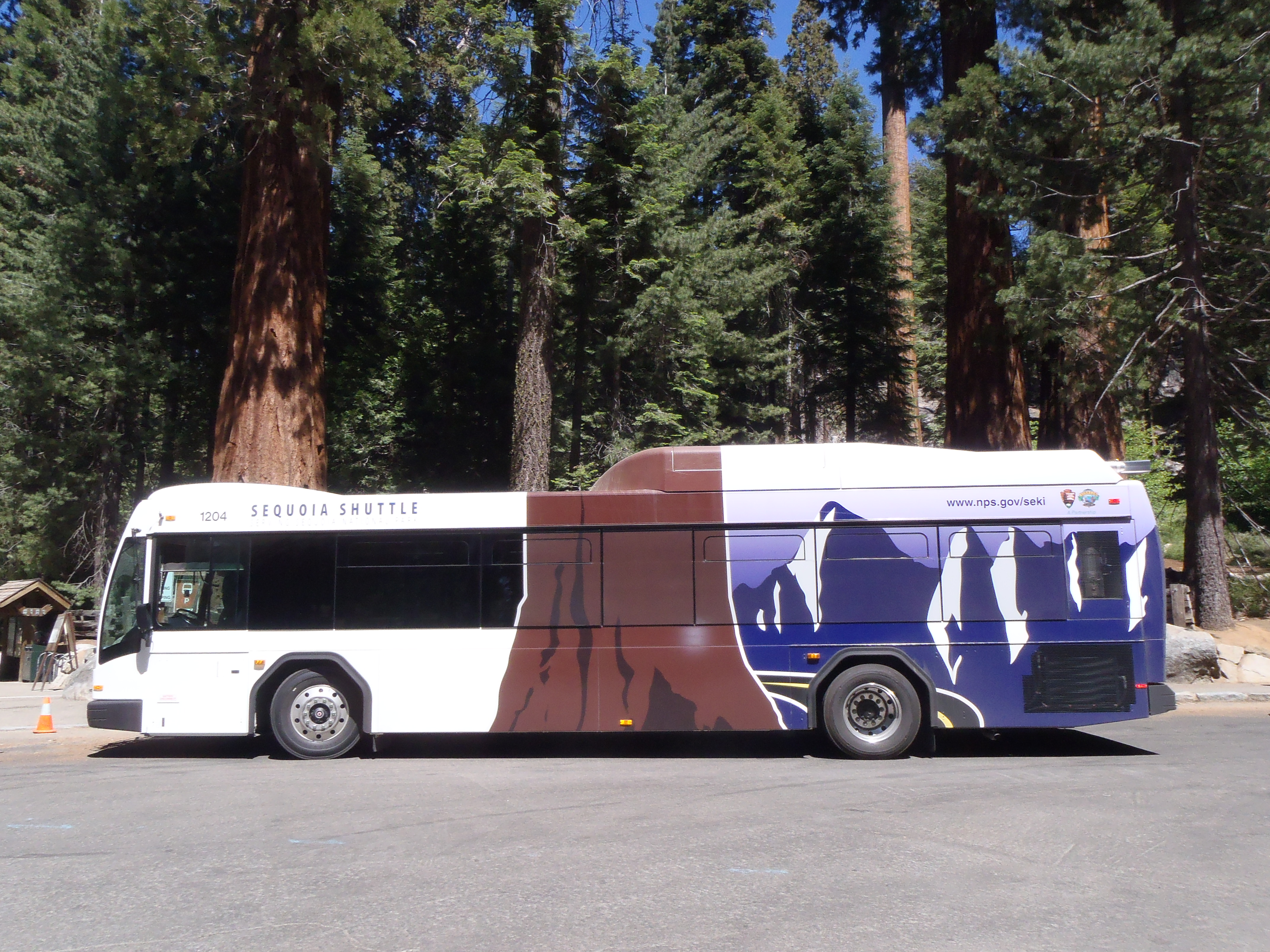
Wherever you go, there you are. SPOTMe!
|
|
|
Re: Trailheads transportation
|
Joined: Sep 2009
Posts: 8,538 Likes: 107
|
|
Joined: Sep 2009
Posts: 8,538 Likes: 107 |
Whatever you do, do not get on this bus: it obviously has directions reversed: That's pretty funny. For those who are wondering: The giant sequoia trunk is ok in the picture, but the Mt Whitney view is all wrong. That profile/view of Mt Whitney is what you see from the east side, which is not even part of Sequoia National Park, and furthermore, the needles to the right of the peak are actually to the left when you view the peak from Lone Pine. I wonder if the driver has to signal left if he's turning right.  THIS is how Mt Whitney appears from within Sequoia National Park -- looking east from Timberline Lake: 
|
|
|
Re: Trailheads transportation
|
Joined: Feb 2011
Posts: 1,572
|
|
Joined: Feb 2011
Posts: 1,572 |
THat profile view is NOT what I see from the east side: Even if you could see it from Sequoia, the other side looks like this: 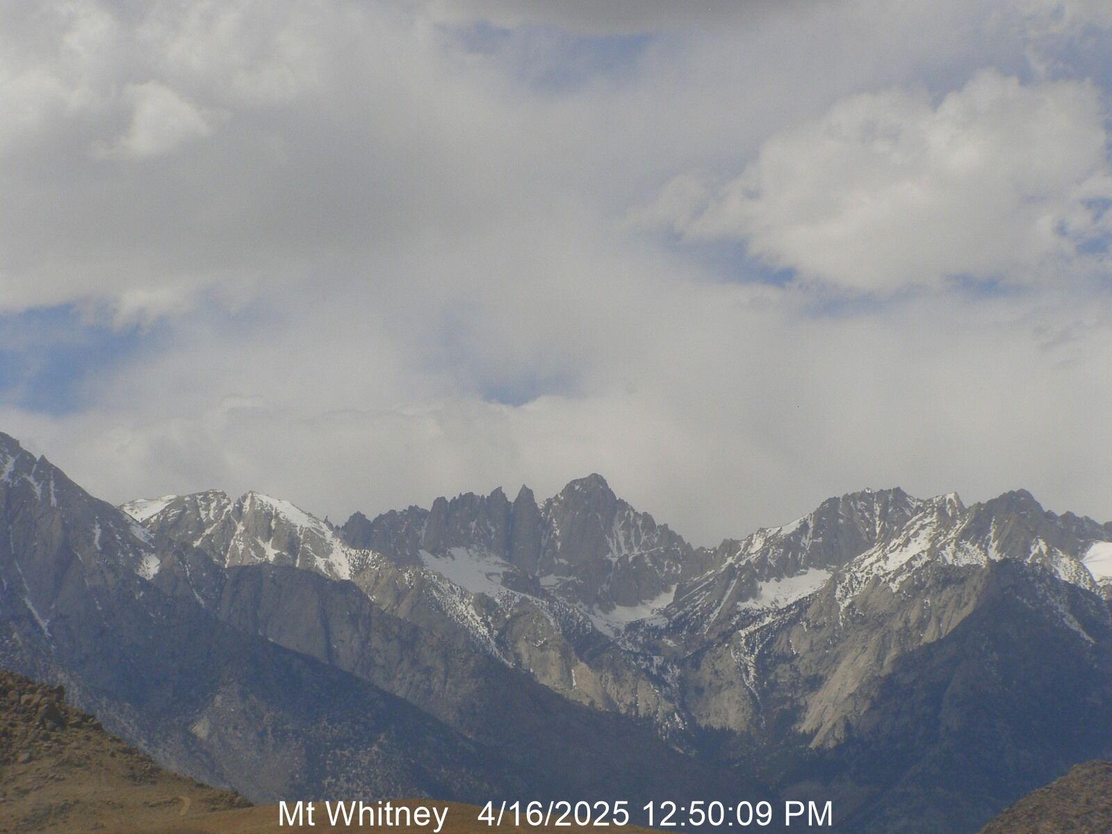
Last edited by saltydog; 08/24/14 06:56 PM.
Wherever you go, there you are. SPOTMe!
|
|
|
Re: Trailheads transportation
|
Joined: Oct 2009
Posts: 2,251 Likes: 1
|
|
Joined: Oct 2009
Posts: 2,251 Likes: 1 |
Whatever you do, do not get on this bus: it obviously has directions reversed: If the artwork is the same on the other side, then the Whitney/Pinnacles handedness will be correct. Meaning the right side is right. So they are batting .500.
Verum audaces non gerunt indusia alba. - Ipsi dixit MCMLXXII
|
|
|
Re: Trailheads transportation
|
Joined: Apr 2010
Posts: 659
|
|
Joined: Apr 2010
Posts: 659 |
I am hopeful. The official logo has it right. http://www.ci.visalia.ca.us/depts/transit/sequoia_shuttle/  There is still the minor detail that the side of the mountains depicted, on east side of the crest, are not actually in SEKI....
|
|
|
Re: Trailheads transportation
|
Joined: Feb 2011
Posts: 1,572
|
|
Joined: Feb 2011
Posts: 1,572 |
Not sure about the logo having it right unless maybe that tree is a big honking Ponderosa Pine
Wherever you go, there you are. SPOTMe!
|
|
|
Re: Trailheads transportation
|
Joined: Apr 2010
Posts: 659
|
|
Joined: Apr 2010
Posts: 659 |
I liberally interpret this logo as a symbol of SEKI's expanse, from the giant sequoia to Mt. Whitney. There's technically no road through SEKI either, though I supposed you could characterize the HST as a hiker highway....
|
|
|
Re: Trailheads transportation
|
Joined: Sep 2009
Posts: 8,538 Likes: 107
|
|
Joined: Sep 2009
Posts: 8,538 Likes: 107 |
Seeing that highway running over the toes of the Sequoia makes me wince.
|
|
|
|
|


