Summary(4:50am) Whitney Portal
(6:15am) E-Ledges
(7:00am) Lower Boy Scout - break for water and food
(8:45am) Clyde Meadow
(10:00am) Upper Boy Scout Lake - rest and food (30min)
(12:30am) Iceberg Lake
-------Camp--------
(4:30am) Chute Above Iceberg Lake
(6:45am) The Notch
(7:50am) Summit via Final 400' (+30min on top)
(8:20am) Began summit descent via Walk-Off Traverse
(9:00am) Chatted with a bunch of climbers at the Notch
(9:45am) Reached Iceberg Lake
(11:45am) Drying / Sleeping / Breaking camp
(4:30pm) Back at Whitney Portal Trailhead
Full Report
Whitney Portal to E-LedgesThe trail is very well maintained - you could easily follow it with a headlamp. The ledges are not as bad as what you'll read online. There is one short section (10 steps?) that has significant fall exposure but its flat and maybe 3ft wide. If you take time to find the cairns you should be ok. I don't have any other detailed pictures of the ledges - most of what you'll see online about navigating the ledges is good beta. The trail after the ledges basically follows the right wall up the valley to lower boy scout lake.
E-Ledges 1 E-Ledges 2
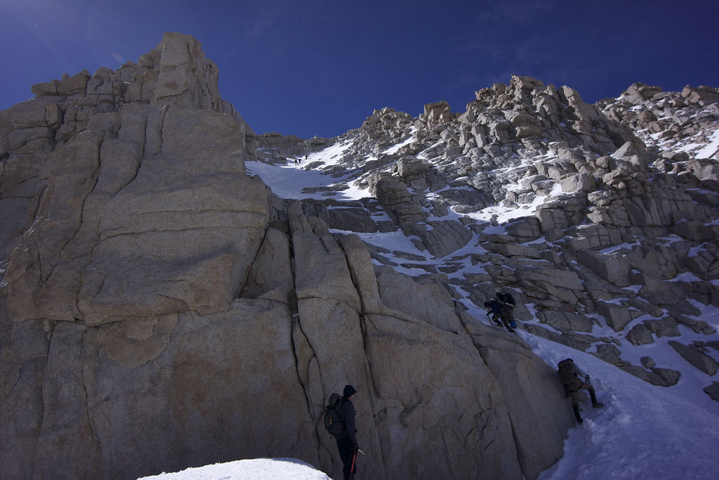
Lower Boy Scout Lake through Clyde MeadowWe stopped here for a minute to enjoy the view, make some water and have a snack. The hiking through Clyde Meadow is pretty straight forward. Head up the obvious valley above LBSL (top center of the first photo). Head towards the cluster of 4 trees in the middle of the valley (Clyde Meadow 2). The saddle to get into the valley that leads to Iceberg Lake will be on your left as your pass these trees. If you get to Upper Boy Scout Lake - you've gone too far. (I'll edit this post with a picture of the turn off)
Lower Boy Scout Clyde Meadow 1 Clyde Meadow 2 Upper Boy Scout Lake to Iceberg LakeOnce gaining the saddle on climbers left before UBSL, you enter a valley which leads to Iceberg Lake. You can take a low route (follows the valley floor) or a high route (stays on the higher right side of the valley). We were stubborn and took
the high route . We climbed the 2nd snow chute we came across which was steep and ended with a couple class 3 moves and a short hike up loose scree to Iceberg Lake. We camped here for the night.
Snow chute to Iceberg Lake
Up the chute to the Notch We left Iceberg lake for the Chute at 4:30am. Snow conditions were great - sunrise was awesome.
Sunrise on the MR Chute We reached the notch and decided to try the Final 400' route to the top. I apologize for only having 1 photo of this section but its not a camera friendly zone

Right in the beginning of the Final 400' there is a rock/mixed section. We went up against the left wall... class 3-4 scramble with rotten snow- another group went for the center up a crack full of ice. Pick your poison. The remainder of this section is steeper than the main chute up to the notch.
Looking Down the Final 400' We didn't have ropes or snow protection so we decided to descend the walk-off route. From the summit hut you basically walk along the edge of the summit plateau, passed the cairn which marks the final 400' to a second cairn which marks the start of the walk-off traverse. Short down climb to access the steep face which will lead you back to the Notch - although it is not directly visible from the start. All I have is a picture of my pals finishing the traverse back at the notch.
Walk-off Traverse from Summit All I recommend is that you get on the chute as early as possible. Snow conditions deteriorated rapidly as the sun came up. By 11 its a miserable slog and I'm not sure a single group who started the chute after 11 made the summit (on that day) although many tried. Even worse - your hike from Iceberg to Lower Boy Scout will take an incredibly long time unless you have snowshoes. You can glissade a lot of the descent but out of good conscience I wont recommend it on a public forum.
Please take this post with a grain of salt (as with anything else you read online). Conditions will have likely changed by the time you are reading it.
Happy Trails,
T.
I'll be uploading other pictures and videos from this route on Instagram - check them out if you want (@turns)