I just got back from a 3 week vacation in Japan where I did a LOT of hiking, more hiking, and even more hiking. Although climbing was a more accurate description.
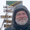
One barely worth mentioning is a hike up Mt Tsurugi-san (6,413 feet/1954 meters) down on Shikoku island (which is south of Osaka). It was mostly a warm up hike since I cheated and took a chairlift part of the way to the peak. Clouds moved in during my climb, so there wasn’t a lot to see from the top anyway.
After that I headed to central Japan to the Japan Alps. This is a range of mountains running roughly north to south between Nagoya and Nagano. They started being called the ‘Japan Alps’ after European climbers saw them and remarked that they looked like the Alps in Europe.
I took what they called the ’Alpine Route’ to get from he eastern side of the Japan Alps to the west side starting point for my hikes: Murodo Station. 8,038 feet/2450 meters.
The Alpine Route is a combination of trolley busses that drive through a deep tunnel carved through the mountains, a large dam you have to walk across, a cable car running up a steep incline, a ropeway hanging down an even steeper slope of Mt Tate-yama, and finally another trolly bus running through another deep tunnel running deep under the peak of Mt Tate-yama. It was kind of weird to be going directly under a peak I intended to climb later.
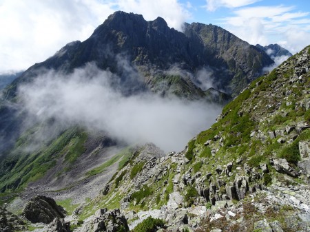
Murodo is a very picturesque mountainous area. It’s also very green. Even with my planning, I was a little amazed at how green the Japan Alps were. I’m a little more used the the rocky Sierra Nevada mountains, I guess.
It’s also an active volcanic area and has various volcanic areas spewing gases and scaring the surface. Looks like it might have gotten more active recently, because some of the hiking trails/boardwalks were closed off. Even one of the mountain huts nearby seemed to be boarded up.
Anyway, this was the starting point for my big hike through the Japan Alps.
The plan:
Start at Murodo and hike north up to the top of Mt Tsurugi-dake.
Then head south to go over Mt Tateyama’s peaks (Onanji-yama and O-yama (Shrine)).
Continue south towards Kamikoshi going over various peaks until hitting Mt Yari-ga-take.
Continue over a really steep and difficult climb they call Daikiretto.
Summit Mt Oku-hotake-dake, the 3rd tallest peak in Japan.
Then descend to Kamikochi, a picturesque valley.
I planned on 5 nights and 6 days to do this roughly 45 mile hike.
The reality:
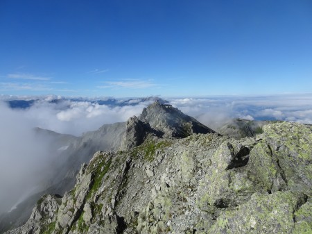
I started out from Murodo and got to the starting point for the hike up Mt Tsurugi-dake. Unfortunately the hike from Murodo took longer than I expected (partly due to my deciding to take a more picturesque route) and the weather had turned pretty bad by this point. The climb would be tricky to do in the rain, plus be a pretty miserable hike with not much to see. So I decided to stay at a mountain hut that was nearest the trail to the peak. This was always the plan to stay there, but I expected to have summited Mt Tsurugi-dake that afternoon.
The next morning was pretty nice, so after enjoying the sunrise I started the hike up to the peak. I had read about the various ‘devices’ they had installed to assist hikers in getting up to the peak, but still was very surprised at the variety, number of, and insanity of trying to climb this mountain using these ‘devices’.
The devices? Here is an brief list:
* Chain link chains used to pull yourself up steep inclines (and later lower yourself down). Think the Half Dome cables, but without the horizontal planks to rest between sections and with chain links that dig into your gloves. Also, probably 6-10 sections to pull yourself up instead of the one long section of the Half Dome Cables. Sometimes there were decent footholds along these routes, but often it was slicker than Half Dome.
* Ladders bolted to the side of nearly vertical and some completely vertical rock faces (and I swear at least one that seemed to be leaning backwards). Think of El Capitan having ladders bolted to the shear faces to climb instead of using ropes and carabiners.
* Horizontal chains fastened to the side of sheer rock faces that you have to hold onto for dear life as you maneuver horizontally across a ridiculously tiny ‘edge’ with your feet. ‘Edge’ isn’t really the right word for what I had to use to make my way across these sections. ‘Tiny little rock outcroppings that barely allow the tips of your shoes to keep you from falling to your death should your hands slip from the cables’ is more accurate. They did paint some of them white so you could figure out where your feet should go.
Even with the descriptions beforehand, I was unprepared for the number, variety, and difficulty of using these devices. It was a very slow and sometimes very scary climb to the peak. It did occur to me several times that I should turn back, but somehow I never quite chickened out. Maybe because it would have been just as hard to backtrack by that point. If I’m going to die, I might as well die trying to reach the summit.

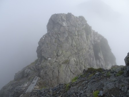
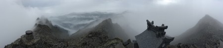
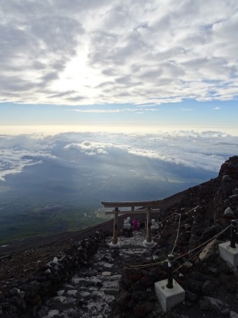
So after a long climb up the side of this mountain, I reached the summit! It was a little overcast by that point, but it still was a spectacular climb and view. As with many Japanese peaks, there was a little shrine up at the top.
After this, I think I can consider myself a mountain ‘climber’ rather than a hiker who hikes up trails to the top of mountain peaks. Basically, some of these routes would be only accessible in the United States by climbers using ropes, carabiners, and other such climbing tools. Not for the faint of heart or casual hikers.
I can now see why the Japanese consider this mountain the holy grail of mountains to climb in Japan. Very challenging and very rewarding if you reach the top.
After enjoying the view and recovering somewhat from the climb, I headed back down. Had to be a easier, than going up, right?
Wrong.
The way down was another assortment of leaders and chains to descend along. Fortunately, there ere some areas where the UP and DOWN climbing routes were separate so you didn’t have to contend with passing people headed in the other direction too much. Really can’t tell you which direction was was worse. That I made it up and down alive is truly a miracle.
I had planned to continue south towards my next goal (Mt Tama-yama) that afternoon, but climbing Tsrugi-dake was a lot more tiring and challenging than I thought. Since I was already behind my original schedule and the next day looked to be okay weather-wise, I decided to stay a second night at the same mountain hut i had the night before. Mostly I was really exhausted after this climb and just wanted to rest for the rest of the day. It also would allow me to stay at a mountain hut just to the south and below Mt Tate-yama the next night. Originally, I’d have been headed further south after Mt Tate-yama, but the delay due to the bad weather and the weather forecast for the following days wasn’t looking too encouraging.
Around this time is when I learned how the mountain huts got resupplied. I saw several helicopters flying to the various mountain huts with large bundles hanging from their undersides. They’d swoop in near the hut and then drop the package. I assume they may dispose of garbage and recycling in a similar matter. No pack mules or people power to resupply these huts. They use small tractors on special tractor paths on Mt Fuji to resupply there, but some of these mountain huts are even more remote and apparently need helicopters to get supplies to them.
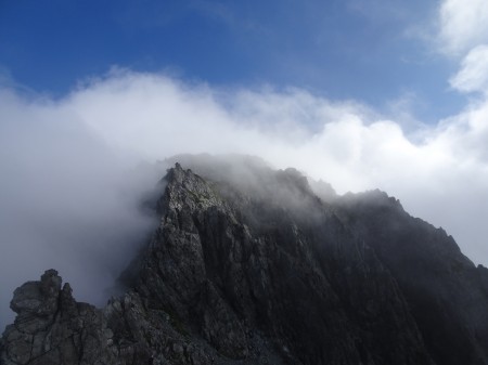
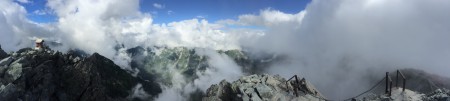
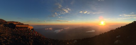
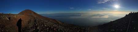
Heading south the next morning, I made my way up several peaks and then up Mt Tate-yama’s main peak (Onanji-yama 9,891 feet/3,015 meters) and a peak with a shrine at the top (O-yama 9,852 feet/3,003 meters). This is also where the crowds started to appear. Since it’s a day hike from Murodo to reach Tate-yama’s peaks, there were a lot of people on this side of the mountain.
It was a little overcast, so the view wasn’t that good but it was still a nice hike and the shrine was interesting to see. The priest gave a little ceremony to the hikers. Not anywhere near as difficult as Mt Tsurugi-dake. Maybe only a couple chains to pull myself up the northern side and a pretty easy trail down the southern side to the mountain hut I stayed at. The trail on this side was a bit crowded from all the day hikers coming up from Murodo).
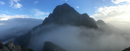
The next morning it was crystal clear, so despite my body’s protests, I decided to go back and climb back up to the shrine and main peak. It was well worth it to see the spectacular 360 degree views.
Making my way back down, I had to decide on my next move. I had planned to go south from here and make my way along the ridge line of the northern Japan Alps towards Kamikochi.
But thanks to several Typhoons hitting Japan in rapid succession, the weather in the Japan Alps for the next 2-3 days looked VERY bad. Since i was already at least 1.5 days behind my original schedule already, I decided to go back down to Murodo.
I had always had a backup plan to skip the section of trail between Mt Tate-yama and Mt Yari-ga-take and do two loops (one around Murodo and one around Kamikochi) to climb the primary peaks I wanted to climb, so I put that backup plan into action.
GPS tracks said it was 18 miles and 11,400 feet climbed/descended. Seemed much longer.
I made my way back to the east via the Alpine Route (with a little better weather this time to enjoy the views as I went) and then decided to head to Tokyo for 2-3 days of rest.
Did I mention the Typhoons?
The first day back in Tokyo, was a torrential downpour due to the typhoon. It made me wish I had headed south where it was a little dryer instead of going to Tokyo, but I didn’t have anything to do to the south and I did have several Tokyo activities on my list.
So keeping my eye on the weather reports for the Kamikochi area and the mountain peaks, I waited out the weather. Fortunately, the weather reports started to look better as the days went on.
Crossing my fingers, I jumped on a train and got to Kamikochi with nice weather to hike to the first mountain hotel in Kamikochi that I was staying the first night at.
The next day was nice and I started the climb from Kamikochi (4,950 feet/1,509 meters) to Mt Yari-ga-dake (10,433 feet/3,180 meters). This was the climb that I was trying to avoid by hiking down from Murodo/Tateyama. In the end, it was a pretty nice—if grueling—hike. Yes, that is possible.
Making it to the Yari-ga-dake mountain hut I was staying at (10,130 feet/3087 meters), I did a afternoon hike up to the peak of Mt Yari-ga-dake (10,433 feet/3,180 meters).
300 feet, no problem, right? Remember those chains and ladders going up to Mt Tsrugi-dake’s peak? They’re back!!
Fortunately, these chains and ladders were not nearly as challenging. Although the final ladders to climb up and down from the summit were a bit nerve-wracking. Perfectly vertical with very little on the sides of them, above them, or below them to grab onto if you fell or the ladder broke off the rock wall. The concrete patches holding them to the mountain were also a bit scary (since that means they broke off the mountain rock at some point, requiring repairs).
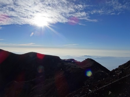
But the view from the top was glorious. Clear, perfect, and awesome!! <insert any other acronyms here that you can, but it still won’t fully describe the view>
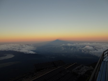
Spent a good hour or two up there and even caught a glimpse of Mt Fuji’s outline in the distance.
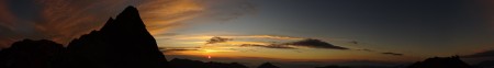
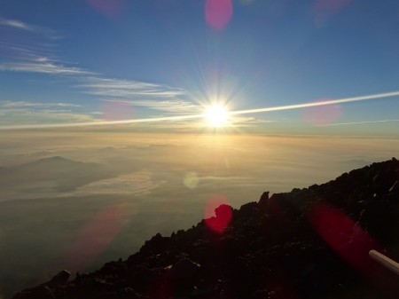
The next mooring I enjoyed the sun rising to the right of Mt Yari-ga-dake’s peak. Kind of wish I’d had the guts to go to the peak for the sunrise, but climbing those chains and ladders in the dark didn’t seem like a good idea. The view of the sunrise from the mountain hut was spectacular, so I’m probably okay with that choice.
Then the day from hell lay ahead of me.
Didn’t know it at the the time, off course.
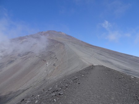
I headed south towards Mt Kita-hotaka-dake (10,190 feet/3,106 meters). They call this stretch of the ridge line trail the ‘Daikiretto’. Daikiretto means "the big cut." It is a knife edge ridge with chains and ladders.
Yes, even more chains and ladders like the ones I so much enjoyed’ using when I went up and down Mt Tsurugi-dake.
Fortunately, they didn’t seem to be quite as challenging as those I had encountered on Mt Tsrugi-dake. But there were more of them and over a longer distance. Maybe I was just getting used to them.
Around this point I saw a helicopter doing some low passes over the area. Unlike the other helicopters I’d seen that were obviously delivering supplies to the mountain huts, this one seemed to be on a search and rescue mission since it was weaving back and forth alongside the ridge. Hopefully, there was a happy ending. Didn’t see any news about this, but them my inability to learn Japanese always makes it hard for me to find current news and follow the news programs on TV anyway. Yes, I did think about hailing the helicopter to take me off the mountain… I was getting very sore by this point.
As the day went on, the clouds moved in and limited my visibility. Just enough so you codlin’t exactly see where the end of the trail would be. My GPS on my iPhone helped let me know where I was in the hike, but it was still a very long and arduous climb up to Mt Kita-hotaka-dake (10,190 feet/3,106 meters). Just a little further from there I made it to the mountain hut I was staying at, which was just shy of the peak of Mt Oku-hotaka-dake (10,465 feet/3,190 meters).
Since it was overcast, there wasn’t much to see at this point and I was dead tired. And at the same time I was amazed that I had made it. Can't use lack of oxygen as an excuse for my exhaustion here, the Japan Alps were all under 10,500 feet.
While Mt Tsrugi-dake was a very demanding climb and descent, this was much longer and challenging. If there was an easy route to abort and go back to Kamikochi, I might have taken it. By the time I thought about that, there wasn’t much point in aborting the hike because all routes would be pretty long and difficult at that point.
Can't use lack of oxygen as an excuse, the Japan Alps were all under 10,500 feet.
So I plopped into my futon for the night and prayed for good weather (but the weather report wasn’t that encouraging).
Morning came, but the sun didn’t. Pretty clouded in. After breakfast, I decided to start my hike up to the summit of Oku-hotaka-dake (10,465 feet/3,190 meters), the third highest point in Japan.
After taking in a very faint view through the clouds at the summit, I made my way back to Kamikochi. Weather report for the afternoon looked better, but didn’t feel that waiting around the mountain hut for most of the morning was something I wanted to do. Guess the strain of the previous day’s long crawl had me thinking of pizza back in Tokyo for dinner.
And after the short climb up Mt Oku-hotaka-dake’s summit, it was all downhill. Easy, right?
WRONG.
After going across to Mt Mae-hotaka-dake (10,137/3,090 meters), I started down to Kamikochi.
That’s when the rain started in ernest. Although not constant, it was frequent enough that it was a very wet slog down a very steep trail (5,000 feet to descend) down to Kamikochi. More chains and ladders awaited me along this ‘trail’.
But I did make it down safely and only felt relieved when I got a cold coke and ice cream cone back in Kamikochi.
And a bunch of souvenirs to celebrate my accomplishment of surviving, of course.
As sore and pained that I felt at the time, I did feel a great sense of accomplishment in being able to do this very long and difficult hike and climb.
Didn’t get my pizza that night, since I had a 3 hour train trip I settled for a nice boxed bento meal to eat along the way.
GPS tracks said it was 29 miles with 13,600 feet climbed and then descended.
Don’t know if I’d have been able to do the full long hike from Murodo to Kamikochi after experiencing the two loops that I did. They were more than challenging with a few days of rest between them. Trying to do the whole hike would have been very hard, especially with the rain.
I dragged myself back to Tokyo for another short rest before I attempted to climb a little mountain called Mt Fuji-san. You may have heard about it.
I don’t consider Mt Fuji-san the highlight of this trip, that honor goes to my two Japan Alps hikes, but it was still fun to go up Mt Fuji again.
Two years ago, I started my Mt Fuji hike from the Fuji Subaru Line 5th station (7562 feet/2305 meters). This time, i wanted to start from the base and do the full Yoshida trail to re-trace the traditional path the pilgrims took when ascending Mt Fuji-san. So I started from Sengen Shrine at the base (2,700 feet/822 meters). Since this isn’t as heavily used by hikers, I had the trial to myself until Umagaeshi. This is the traditional point that horses could goto, but had to turn around. Now it’s also the furthest cars can drive to on this lower part of the trail. There was a nice couple manning the hut at Umagaeshi and gave me some info and some green tea.
After that there was a lot of traffic on the trail due to busses of day hikers and school children, most didn’t look like they were headed to the summit. This lower half of the trail mostly had old mountain huts and shrines, most in disrepair. Umagaeshi as the only hut providing water/tea until the huts at the 5th station. It was late in the hiking season, so maybe there would have been some more activity and supplies on this trail earlier in the season, but there was only one hut that looked intact enough to actually still be usable.
It was also mostly forest until I reached the original 5th station and had a bowl of ramen for lunch. I decided not to take the detour over to the Fuji Subaru Line 5th station, since that would be an extra one and a half miles of hiking. I saw it last time, so there wasn’t anything in particular to see or do there.
So it was onward and upward. Past the 6th station where most of the other hikers joined the trail and to the 7th station. This is where it started to get really steep. I had the option to stop here and stay a hut for the night, but still felt pretty good. So I pressed forward to the original 8th station (11,000 feet/4452 meters) where I had a reservation at a mountain hut.
I have to say, I barely made it all the way there. Without the reservation, I’m sure I would have stopped somewhere lower.
Still 8,300 feet elevation gain in one day was a new record for me, so can’t sneeze at that accomplishment.
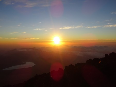
After a much needed rest, I headed to the summit 2 hours before dawn to see the sunrise from the summit. Unlike last time, the skies were clear and it was a spectacular light show across the eastern skies.
Then it was time for a slow hike around the summit crater. I took in the two main shrines at the top, climbed 5 of the “8 summits of Mt Fuji”, and generally enjoyed the day at 12,388 feet/3,776 meters.
My original plan was to go back down to the nearest hut to the summit at the 8.5 station (11,300 feet/3,444 meters) and go up to the summit the next morning to double my chances of seeing a spectacular sunrise (the first time I went up Mt Fuji it as very cloudy, so I only had brief glimpses of the sun at sunrise). But with that morning already clear and spectacular, I debated heading down the Gotemba Trail and back to Tokyo a day early.
But since I had a non-refundable deposit on the 8.5 station mountain hut and nothing in particular to do back in Tokyo, I decided spending another night on the mountain and seeing a mother sunrise from the summit was still a good idea.
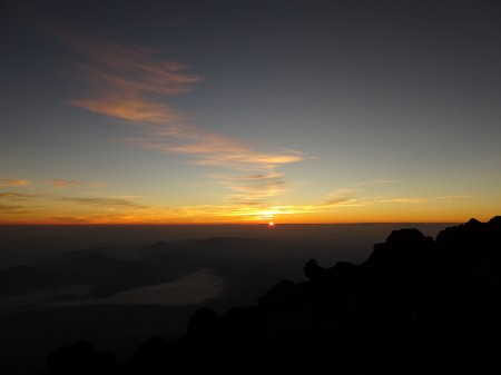
Don’t know if i can claim to have summited Mt Fuji-san three times or if two is more accurate, but I had fun. And the sunrise was a little more specular the second morning due to some low lying clouds to liven up the light.
After enjoying the sunrise and taking even more pictures, I headed down via the Gotemba Trail on the south side of the mountain. I decided on this trail since it would be a new trail for me, new sights, and had an interesting feature called Osunabashiri (great sand run).
So I made my way down, visiting some of the mountain huts on the way and also a short side trip to Mt Hoai (8,835 feet/2,693 meters),which was a volcanic summit on the side of Mt Fuji.
Then I started running down Mt Fuji.
Yes running.
The Osunabashiri is a large area on the side of Mt Fuji consisting of fine volcanic sand. When descending it, you can take large steps and bound down a third of the height of the mountain. You can even RUN down. The loose sand cushions the blow to your knees and really cuts the time to descend drastically. While I didn’t run all the way down this section, I did do quite a bit of sprinting.
It was quite fun.
I almost fell a couple of times, but didn’t wipe out once during this final ‘hike’ of my trip. Definitely a nice thrill to finish the hike on.
GPS tracks said it was 26 miles and 15,300 feet climbed/13,300 feet descended.
Unlike my first time up and down Mt Fuji back in 2014 where I felt absolutely dead and stumbled several times as a I made my way back to the 5th Station, I felt pretty good at the end of this hike. Not sure if it was the rush of the ‘run’ or just that i’ve gotten in better shape than I was two years ago (probably a bit of both), but I headed back to Tokyo feeling pretty good about all that I managed to accomplish during this trip.
I did finally get my pizza (from Pizza Hut) to celebrate and began the impossible task of repacking my suitcase and backpack with all the t-shirts, souvenirs, and other stuff I bought during this trip.
Most importantly I had to get my Japan Alps and Mt Fuji hiking sticks back to the USA. Last time, I had to scramble since Delta wouldn’t let me carry it on the plane. Ended up paying a lot for a third piece of baggage. This time i made sure to have some long cardboard tubes to pack the hiking sticks into along with some of my other many souvenirs. Careful packing and taking my backpack as a carry-on allowed me not to pay any additional fees.
The Mt Fuji hiking stick was particularly special, since the mountain huts each have unique ‘brands’ they burn into the hiking stick as you climb and descend the mountain. The shrines at the bottom and top of the mountain also have a stamp they can apply. It became quite the unique souvenir of my climb. The Japan Alps hiking stick was a little plainer since they don’t have brands at the mountain huts there, but it’s still reminder of my hikes there, plus I attached some pins I bought along the way that symbolize the mountain peaks I scaled.
All in all, it was a great 3 weeks in Japan that I’m sure it’ll take me weeks to recover from (and months for my wallet to recover from).
So at least 73 miles hiked up and down various Japanese mountains. Add all the walking elsewhere, and I probably put 100 plus miles on my old legs. I hope the 170 miles my Apple Watch insists I walked is wrong, because that would put me out of warranty.
Quick list of peaks scaled during this trip:
Tsurugi-san (Shikoku) 6,413 feet/1954 meters
Started hike from Murodo Station 8,038 feet/2450 meters
Tsurugi-gozen 9,110 feet/2,777 meters
Ippuku-tsurugi 8,589 feet/2,618 meters
Mae-tsurugi 9,229 feet/2,813 meters
Tsurugi-dake 9,839 feet/2,999 meters
Bes-san 9,429 feet/2,874 meters
Masago-dake 9,386 feet/2,861 meters
Fujinoori-take 9,839 feet/2,999 meters
Tateyama Peaks (hiked up to each twice):
Onanji-yama 9,891 feet/3,015 meters
O-yama (Shrine) 9,852 feet/3,003 meters
Return to Murodo Station
Started hike from Kamikochi 4,950 feet/1,509 meters
Yari-ga-take (10,433 feet/3,180 meters)
Obami-dake (10,173 feet/3,101 meters)
Naka-dake (10,118 feet/3,084 meters)
Minami-dake (9,950 feet/3,033 matters)
Survived the Daikiretto
Kita-hotaka-dake (10,190 feet/3,106 meters)
Karasawa-daka (10,203 feet/3,110 meters)
Oku-hotaka-dake (10,465 feet/3,190 meters) Third highest point in Japan
Mae-hotaka-dake (10,137/3,090 meters)
Return to Kamikochi
Mt Fuji-san (12,388 feet/3,776 meters)
I reached the top of 5 of the 8 summits on Mt Fuji (the other three were either off limits (Hakusandake and Sengendake) or I couldn’t figure out a way to climb it (Izugatake):
- Kengamine (elev. 12,388 feet/3776 meters, Japan's highpoint)
- Kusushidake (12,204 feet/3,720 meters)
- Joujugatake (12,250 feet/3,734 meters)
- Asahidake (12,247/3,733 meters)
- Mishimagatake (12,250 feet/3,734 meters)
Other high points I hit on Mt Fuji:
Ikazuchigaiwa (12,240 feet/3731 meters) I’m not sure why this isn’t considered one of the eight (nine?) summits of Mt Fuji, since it’s a high point around the crater.
Hoai-san (8,835 feet/2,693 meters) this is a peak rising from the southern side of Mt Fuji that I visited on the way down the Gotemba trail)
Mt Tsurugi-san, Iya Valley, and Oboke Gorge Highlights:
https://flic.kr/s/aHskJgbJF5Just the BEST of the highlights:
https://flic.kr/s/aHskGV62P8Matsumoto and Alpine Route Highlights:
https://flic.kr/s/aHskGGGzvoMurodo, Mt Tsurgi-dake, and Mt Tate-yama Highlights:
https://flic.kr/s/aHskDpVn9wJust the BEST of the highlights:
https://flic.kr/s/aHskGUVGkMKamikochi, Mt -Yara-ga-dake, and Mt Oku-hotaka-dake Highlights:
https://flic.kr/s/aHskGzHUWAJust the BEST of the highlights:
https://flic.kr/s/aHskGTNTeaMt Fuji-san Highlights:
https://flic.kr/s/aHskGLq6J8Just the BEST of the highlights:
https://flic.kr/s/aHskDz2BTK