|
1 members (mahboud),
437
guests, and
11
robots. |
|
Key:
Admin,
Global Mod,
Mod
|
|
 lost hiker -- Found
|
Joined: Jun 2017
Posts: 11
|
OP

Joined: Jun 2017
Posts: 11 |
Edit: He's been found safe! Our trip organizer to Mt Whitney, Marv Cope, is missing after the one day hike we did yesterday, June 28th. He was last seen in the rocky area on the eastern side of Whitney. He might have been heading down to the valley. Marv is 6'2'', 62 yo, has blue eyes and greyish hair. Here is a picture of him taken yesterday at the summit. If you have any information about him, please call Bryan Howard from the Inyo County Search and Rescue at 760-937-3234. 
Last edited by Steve C; 06/29/17 10:32 PM.
|
|
|
Re: lost hiker
|
Joined: Jun 2017
Posts: 11
|
|
OP
Joined: Jun 2017
Posts: 11 |
We were three people who went down by mistake on the eastern side of the mountain and got lost in the large field of boulders.
After we lost Marv, we met several groups of people who also got lost by making the same mistake.
|
|
|
Re: lost hiker
|
Joined: Feb 2011
Posts: 1,572
|
|
Joined: Feb 2011
Posts: 1,572 |
Heading down to what valley? Guitar Lake? Crabtree? YOu might want to post on PCT, John Muir Trail and Whitney Facebook Pages: lots more coverage
Last edited by saltydog; 06/29/17 03:08 PM.
Wherever you go, there you are. SPOTMe!
|
|
|
Re: lost hiker
|
Joined: Jun 2017
Posts: 11
|
|
OP
Joined: Jun 2017
Posts: 11 |
Thanks, we'll post it there, too.
We were on the eastern side, I think we could see what I found later is Pinnacle.
|
|
|
Re: lost hiker
|
Joined: Jun 2017
Posts: 11
|
|
OP
Joined: Jun 2017
Posts: 11 |
After talking to the SAR, I think we were facing somewhat towards the Mountaineering Route. We saw a snow chute below us.
|
|
|
Re: lost hiker
|
Joined: Feb 2013
Posts: 126
|
|
Joined: Feb 2013
Posts: 126 |
Have posted this on our site(HST), Yosemite Forum, Yosemite News and Info, Summitpost, Supertopo, Mountain Project, Backpacker, Rock Creek Message Board, and Eastern Sierra Forum too.
|
|
|
Re: lost hiker
|
Joined: Feb 2013
Posts: 126
|
|
Joined: Feb 2013
Posts: 126 |
|
|
|
Re: lost hiker
|
Joined: Feb 2013
Posts: 126
|
|
Joined: Feb 2013
Posts: 126 |
Inyo Co Sheriff's Dept:
UPDATE: Missing hiker Marv Cope has been located alive and well near the Arctic Lake drainage area in Sequoia-Kings National Park. A big THANK YOU to Sequoia and Kings Canyon National Parks and CHP - Inland Division Air Operations!
Last edited by Maverick; 06/29/17 06:53 PM.
|
|
|
Re: lost hiker
|
Joined: Jun 2017
Posts: 11
|
|
OP
Joined: Jun 2017
Posts: 11 |
Yes, he made it to the Guitar Lake area and met the rangers who were looking for him. Thank God, it was a happy ending.
And he is indeed the author of that book.
|
|
|
Re: lost hiker
|
Joined: Sep 2009
Posts: 8,538 Likes: 107
|
|
Joined: Sep 2009
Posts: 8,538 Likes: 107 |
I really want to hear the story how all of this unfolded!!
Sure glad he is safe.
|
|
|
Re: lost hiker
|
Joined: Jun 2017
Posts: 11
|
|
OP
Joined: Jun 2017
Posts: 11 |
After becoming separated from Marv, I and the third hiker started to go back up the mountain. After a few minutes we met several other groups of people who also realized they were lost and followed them. I looked at the gpx trail of my route (I've been getting accustomed to gpx only in the last couple of days) and it seems that we went on a trail that made a big detour farther west before getting back to the trail that leads to Trail Crest.
Marv kept going down by himself and he reached Arctic Lake. He suffered from cold during the night, but he managed to maintain some body heat using the Mylar blanket he had with him. Today, while the search & rescue operation was in progress, he saw a helicopter hovering in the sky. He tried to use his mirror to get their attention, but he was not noticed. He kept walking towards Guitar Lake where a group of hikers directed him to the rangers station. On his way there, he met the rescue team from Sequoia National Park. He was later flown by helicopter to Lone Pine.
I also want to say that all of us were impressed by how professional and well organized the search & rescue teams are. We were also very impressed by how many people in Lone Pine were offering their help, such as by printing the flyers that were distributed at the Portal. Everybody at the Portal was also extremely helpful and were volunteering their time to spread the information about Marv.
|
|
|
Re: lost hiker -- found
|
Joined: Sep 2009
Posts: 8,538 Likes: 107
|
|
Joined: Sep 2009
Posts: 8,538 Likes: 107 |
Nico, thanks for the reply. I hope you will continue to answer some questions. Your writing could help other hikers on Whitney.
Did your group go up the Main Trail, or up the Mountaineers Route?
Would also like to know... when did the group split apart?
I am having difficulty understanding the N-S-E-W directions. Lone Pine is East of Mt Whitney, so being on the east side means you were descending in the right direction. Arctic Lake is on the north side, Guitar Lake and the ranger station area is west of Mt Whitney.
|
|
|
Re: lost hiker -- found
|
Joined: Jun 2017
Posts: 11
|
|
OP
Joined: Jun 2017
Posts: 11 |
Hi, Steve I was completely wrong about being on the Eastern side, I will explain the whole thing. We went up the main trail. None of us really had mountaineering experience. Only three of us made it to the crest. The others gave up because of the snow. For me, the snowed area did not feel dangerous, just slow, but for people who never lived in a place that has winter it might seem scary. I had the Hillsound traction devices which are very similar to micro-spikes, an ice axe and gaiters. None of the people who were in my usual hiking mini-group for training hikes made it to the crest. So I was with two people who were more focused on accomplishing the summit, whereas I am more of the kind who sticks to a team. Most of the time, on the crest, each hiked on his own, since we had different speeds. But the three of us were together at the summit and took a few pictures. On the way down, I was initially just following them. I did not have enough confidence in my experience with GPS (but I got better as the day progressed). The other two were convinced we were going the right away, but they did not agree on which way to go. I was more and more convinced that we were not on the same side we came, because the crest looked different and the rocks below looked different. I think this is the part of the crest we were seeing. Here is my GPS track of that day. (Please ignore the big spike, it was probably a software error, we did not go to Thor Peak.) As you can see, we were too far West. We could see a trail in the distance, but it did not look like the trail we came on. We could see some lakes down below, probably Arctic Lake or Guitar Lake. At some point, I lost track of Marv, but I was still able to go to the third hiker, who was the fastest of us three. After we realized we cannot find Marv anymore, she started to panic and it took me a while to calm her and to convince her to go back up the mountain. We did not need to go very far, because we met two large groups of hikers who were also looking for the trail. They figured out a way to get to the trail which was visible in the distance, we followed them, and after a while that trail merged back into the main trail, which took us back to the Chute. It would be nice to have some trail signs going from the main trail up to the summit and down back, at least for people who are not familiar with the mountain. I was told there is usually a visible trail there, but parts of it are now covered by snow.
Last edited by Nico1234; 07/01/17 01:46 PM.
|
|
|
Re: lost hiker -- found
|
Joined: Jul 2016
Posts: 4
|
|
Joined: Jul 2016
Posts: 4 |
Thank you for posting this information and the GPS track. I'm curious to know why you didn't use the GPS to find your way back to the trial?
Last edited by CEric G; 07/01/17 03:44 PM.
|
|
|
Re: lost hiker
|
Joined: Jan 2015
Posts: 5
|
|
Joined: Jan 2015
Posts: 5 |
Yes, he made it to the Guitar Lake area and met the rangers who were looking for him. Thank God, it was a happy ending.
And he is indeed the author of that book. When did they find him? Did he spent an uplanned night on the mountain?
|
|
|
Re: lost hiker -- found
|
Joined: Jun 2017
Posts: 11
|
|
OP
Joined: Jun 2017
Posts: 11 |
I was a bit confused by all the squiggly lines in the GPS app. And I was relying too much on the two other people to know the way and to use their GPSs. I think that now I would be more confident and more comfortable with the gpx, since I used it to navigate back down later in the day.
Another thing is if you go the wrong way too far it becomes quite hard to go back. That area is made up of rocks of various sizes, so instead of walking you are jumping from rock to rock. We were lucky there was trail nearby. The maps I saw at REI only show one trail going to the summit, they don't show all the variants.
|
|
|
Re: lost hiker
|
Joined: Jun 2017
Posts: 11
|
|
OP
Joined: Jun 2017
Posts: 11 |
He spent one cold night on the mountain and he used a Mylar blanket.
|
|
|
Re: lost hiker -- found
|
Joined: Aug 2011
Posts: 464 Likes: 1
|
|
Joined: Aug 2011
Posts: 464 Likes: 1 |
It looks to me like on the way up near the summit you took a well traveled short cut to the east of the last snow field. But on the way down you went on the opposite side of that snowfield maybe closer to the regular Main Trail. After circling the snow you found your way back to the trail you came up.
|
|
|
Re: lost hiker -- found
|
Joined: Sep 2009
Posts: 8,538 Likes: 107
|
|
Joined: Sep 2009
Posts: 8,538 Likes: 107 |
Nico, The Summit Post picture you referenced is exactly what you needed to see on the way down. The high points are the Whitney "needles", and the low spots are the "Windows". If you click on the picture and enlarge it, you can see hikers in the lower left, and also near the first window. That is the trail you came up on, and the same trail you returned on. You were RIGHT ON TRACK! If you don't stop and turn around once in a while, the return trip often looks really different that the climb. Your GPS track shows sort of a loop on the left side near the top end of your hike. The part to the left is the current trail route. The more direct short-cut on the right is an old trail, but you can't find it in summer unless you know exactly where to look. But right now, it is a snow field there, so you and your group likely followed all the tracks and climbed up to the summit using that route. On your return, you followed the obvious trail, and it took you on the round-about way. The lakes you saw on the return were the same you could have seen on the way up -- Guitar Lake and Hitchcock Lakes. The spike in your track is just an anomalous coordinate that gps units often record when you are in a canyon, where it can't pick up enough satellites to get a reliable location. Again, you were on the trail, you just took a different variation on the way down. It is extremely curious how Marv got so far off course. It is possible that he took a right turn off that little spike on your loop at the top -- If there is snow there, he could have followed tracks from hikers climbing and descending the "easy walk-off" route of the Mountaineers Route. Since there is likely a full snow field all the way down to Arctic lake, he probably could have descended on it safely to that valley. He would then need to circumnavigate around from Arctic Lk. (A man his age died there over a year ago thinking it was a shortcut down to where the Crabtree ranger station is. Marv had snow. The deceased tried it on bare granite.) Here's a copy of your map: 
|
|
|
Re: lost hiker -- found
|
Joined: Apr 2012
Posts: 579 Likes: 3
|
|
Joined: Apr 2012
Posts: 579 Likes: 3 |
I've zoomed in on Nico's route using two different maps within View Ranger, and you can see how far Nico wandered from the trail. First is using Google Physical Map 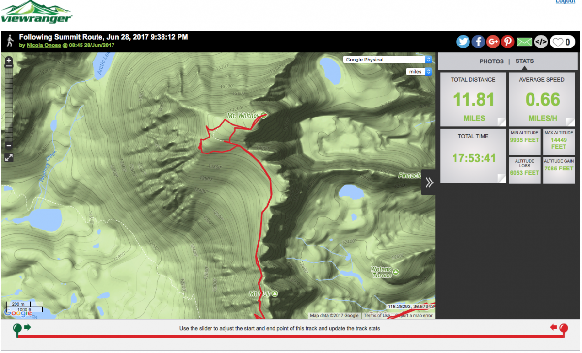 Second is using Open Cycle Map 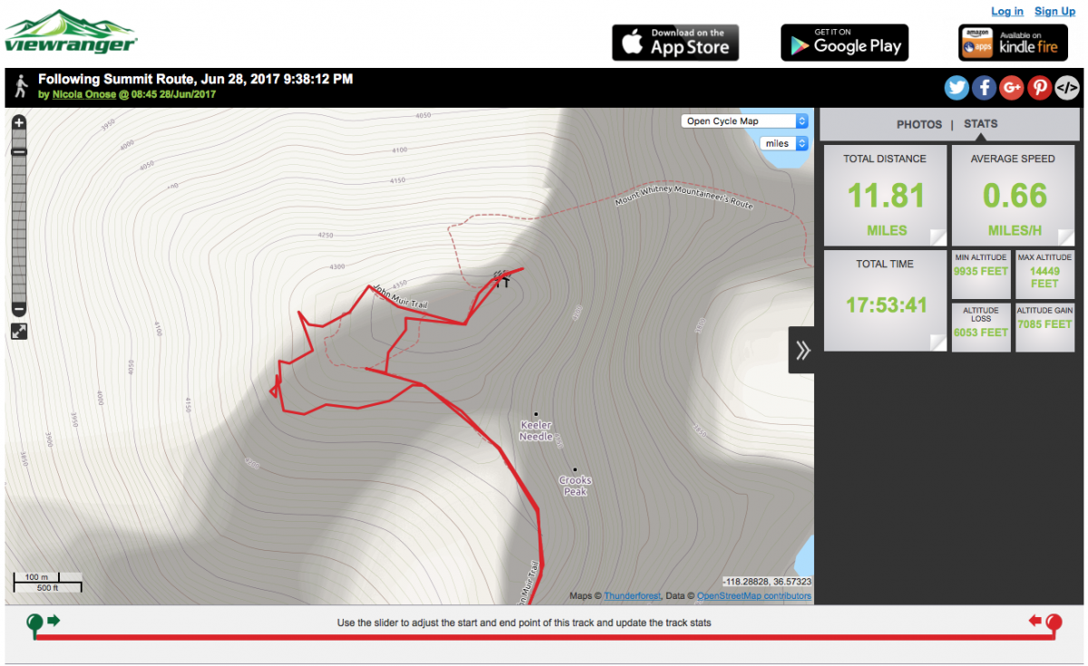 You can also verify that these two maps fairly represent the trail by using Google Satellite Map. The trail is visible if zoomed fully in. No wonder that Nico commented on the boulder field.
|
|
|
Re: lost hiker -- found
|
Joined: Sep 2009
Posts: 8,538 Likes: 107
|
|
Joined: Sep 2009
Posts: 8,538 Likes: 107 |
I've zoomed in on Nico's route using two different maps within View Ranger, and you can see how far Nico wandered from the trail. First is using Google Physical Map Second is using Open Cycle Map You can also verify that these two maps fairly represent the trail by using Google Satellite Map. The trail is visible if zoomed fully in. No wonder that Nico commented on the boulder field. Oh wow!!! They really were off route!!! Thanks, John, for the images.
Last edited by Steve C; 07/02/17 11:03 AM.
|
|
|
Re: lost hiker -- found
|
Joined: Jul 2017
Posts: 9
|
|
Joined: Jul 2017
Posts: 9 |
yea we shouldn't follow that route man that spike is really weird 
|
|
|
Re: lost hiker -- found
|
Joined: Jul 2017
Posts: 2
|
|
Joined: Jul 2017
Posts: 2 |
I really appreciate everyone's help in getting me back to Lone Pine. Nico did a fantastic job explaining things. I am the one who went down the rocks looking for the trail. I want to offer up my GPS track if you're interested to match up with Nico's and see where I started down looking for the trail and why I ended up at Guitar Lake. The GPS map is at Mount Whitney Hike 2017 I'm hoping adding this bit of information and offering to answer questions may help others.
Last edited by Marv; 07/02/17 01:25 PM.
|
|
|
Re: lost hiker -- found
|
Joined: Sep 2009
Posts: 8,538 Likes: 107
|
|
Joined: Sep 2009
Posts: 8,538 Likes: 107 |
Marv: Thanks SO MUCH for posting your track. Where it ends at the 13,600 elevation, did you just continue on down from there? It has got to be really steep, but maybe with crampons, you could manage it. So glad your trip ended ok!!! Last July, this hiker's life ended in the same general area as your descent -- near Guitar Lake, above the JMT. But he tried descending through the rocks, I believe. Link: Missing man on MR -- RecoveredI am posting the image of your track here (click to enlarge) 
|
|
|
Re: lost hiker -- found
|
Joined: Jul 2017
Posts: 2
|
|
Joined: Jul 2017
Posts: 2 |
Thanks for posting the map, Steve. I think it helps to better understand where I veered off from Nico. The GPX track stops at that point because I turned it off to save the battery (10% left on the external phone battery).
This point was the last slightly level spots I could lay down without sliding. After spending the night, I began sliding down again on my butt, taking paths that did not require large drop-downs to the next levels. This worked until I could go no further except with larger boulders or in the snow. I used crampons for the last 1,600 to 2,000 feet to the valley floor. I came out between Arctic Lake and Guitar Lake.
|
|
|
Re: lost hiker -- found
|
Joined: Jul 2016
Posts: 4
|
|
Joined: Jul 2016
Posts: 4 |
I was a bit confused by all the squiggly lines in the GPS app. And I was relying too much on the two other people to know the way and to use their GPSs. Thank you Nico for replying. I'm so glad that you and your group made it out okay. It sounds so simple but I think the big takeaway here is to know how to use your GPS. At leat two out of the three in this group had a device. Marv said he turned his off to save his phone battery. Something to consider if you find yourself in a similar situation is to text your GPX coordinates to someone who knows about your trip. I've been able to text when it appears that there's not enough signal to make a call. Again, I'm so glad everyone is okay.
|
|
|
Re: lost hiker -- found
|
Joined: Feb 2010
Posts: 657 Likes: 58
|
|
Joined: Feb 2010
Posts: 657 Likes: 58 |
I think the big takeaway here is to know how to use your GPS. Nope. The key is to pay attention to your surroundings and learn basic navigation skills. You should always know what direction the summit is, what direction your camp is, and what direction your car is. If you simply head in the general direction of down, will you end up near your camp, your car, or both? Or will you end up in Fresno? 99% of the time, you don’t even need a map and compass, let alone a GPS, to know this. Pay attention! Identify landmarks you can recognize on the way back. Don’t rely on your partners or a battery-dependent electronic gizmo to save your butt. Here is an extreme example: 21 years ago, my partner and I reached the summit of Mt. Williamson (14,370+) at 4:30 in the afternoon. It was February, it would be dark in half an hour, there was no moon, and it was starting to snow. And we had to descend some third class rock that now had snow on it without a rope. Four hours later, we were walking in 6” of fresh snow, and our old pre-LED headlamps had been off for 15-20 minutes to save batteries. We hadn’t looked at the map in a long time, if at all. We decided that we must be near camp. We turned on our headlamps and camp was thirty feet away. There is a lot more to navigation than knowing how to use your GPS.
|
|
|
Re: lost hiker -- found
|
Joined: Nov 2009
Posts: 1,037 Likes: 6
|
|
Joined: Nov 2009
Posts: 1,037 Likes: 6 |
I think the big takeaway here is to know how to use your GPS. Nope. The key is to pay attention to your surroundings and learn basic navigation skills. DITTO DITTO DITTO
|
|
|
Re: lost hiker -- found
|
Joined: Jul 2016
Posts: 4
|
|
Joined: Jul 2016
Posts: 4 |
I think the big takeaway here is to know how to use your GPS. Nope. The key is to pay attention to your surroundings and learn basic navigation skills. You should always know what direction the summit is, what direction your camp is, and what direction your car is. If you simply head in the general direction of down, will you end up near your camp, your car, or both? Or will you end up in Fresno? 99% of the time, you don’t even need a map and compass, let alone a GPS, to know this. Pay attention! Identify landmarks you can recognize on the way back. Don’t rely on your partners or a battery-dependent electronic gizmo to save your butt. Here is an extreme example: 21 years ago, my partner and I reached the summit of Mt. Williamson (14,370+) at 4:30 in the afternoon. It was February, it would be dark in half an hour, there was no moon, and it was starting to snow. And we had to descend some third class rock that now had snow on it without a rope. Four hours later, we were walking in 6” of fresh snow, and our old pre-LED headlamps had been off for 15-20 minutes to save batteries. We hadn’t looked at the map in a long time, if at all. We decided that we must be near camp. We turned on our headlamps and camp was thirty feet away. There is a lot more to navigation than knowing how to use your GPS. I bet that I’m as old school as you when it comes to navigating. Your advice, “pay attention to your surrounding and learn basic navigation skills” sounds good but maybe you are not aware that some people don’t have the same cognitive mapping skills that you and I have. In other words they have no sense of direction. My wife is that way. We’ve hiked hundreds of miles together and for years I’ve pointed out all the surroundings landmarks and features and yet she still can get lost walking through Taos square. For her and many others it is not something that can simply be learned. Regardless of how Marv and Nico got lost what I can’t wrap my mind around is how Marv continued down the wrong valley and turned off his GPS. I don’t want to criticize Marv. I wasn’t there. But why didn’t he use it to reacquire his bearings? Sorry Marv – no disrespect. I’m so grateful you are okay! Regarding “There is a lot more to navigation that knowing how to use your GPS”. Thank you, I had no idea (rolling my eyes), but I think you missed my point. I wasn’t making an argument that a GPS is the end all to navigation. Nor should any hiker be dependent on that technology. That would be stupid and I think you know it. What you missed is that in this thread we learned that Marv and Nico each had a working “battery-dependent” GPS device when they went the wrong way and got lost. I doubt they were using it when they got lost. So it doesn’t look like they were dependent on it. It looks more like they didn’t use it to get back on the trail. Do you think Marv tried to text his latitude longitude coordinates that night? He didn’t mention if he had a ‘track back’ or ‘go to’ feature on his GPS. Nico didn’t say anything about finding Marv using a location sharing app. I can’t say whether or not any of these would have worked but you can’t say that they would NOT have worked. And maybe help someone in the future. This is real simple. If you have the GPS gizmo, and the gizmo has 10% battery-dependent life left, and you are lost, maybe you should know how to use the gizmo to find the trail or send your location, etc.
|
|
|
Re: lost hiker -- found
|
Joined: Sep 2009
Posts: 8,538 Likes: 107
|
|
Joined: Sep 2009
Posts: 8,538 Likes: 107 |
CEric G: There is NO cellular reception in the areas where Marv was or where they lost their way. NO texts would get out, and it would further drain the cellular device's battery searching for service.
People are lucky to get a connection at t he summit. The only units that can report locations where they were are either SPOT or InReach units.
I have a Garmin gps unit, and I can assure you, figuring out where you are on those tiny maps with a tiny triangle visible makes it really hard to figure out where you are. We don't even know if their gps units even had a decent map loaded.
|
|
|
|
|


