This is a poster-sized drawing of Mount Whitney that I drew. The first image shows the poster inside an inexpensive 22 inch by 28 inch picture frame.
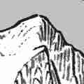
The second image shows the heart of the region, with a hand in the foreground (for scale).
The third image shows an abbreviation key, which is located in the lower right corner; it lists the features you can expect to find on the artmap. My camera skills are not as good as my drawing skills, and the so colors are a little off on these three photographs.
The fourth image is a 4 inch square sample from the actual data file (the one sent to the printers). This image has the greatest color fidelity; this is what it looks like in real life. The printers did a good job.
The last image is a fun picture -- to encourage sales! -- which showcases the utility of the artmap. On the left side is a sample snapshot from a local webcam. Below it is a duplicate copy, daubed with colorful tints, for the sake of isolating and identifying the landforms. On the right side is an elliptical vignette taken from my poster; the color saturation is dialed w-a-a-ay down, so that''s almost a grayscale image. Onto this I added the same tinted colors that I used on the secondary webcam image. The peaks and ridgelines are thus easy to recognize. It's not a perfect match, of course, because my drawing style is light and playful. Still, I tried to capture the shape of the land. The Whitney region has some stunning topography, and I tried to convey that.
If you are interested in purchasing a copy of this artmap, please check out the following link:
https://pencilstrength.thedribble.com/l/whitneyposterThank you for checking out my art, and have a great day!
Sincerely,
Carl Raillard