Short version: A 500 pound rock fell on me, but I came out OK. Didn't make it to the summit.
Last weekend (June 26), my friend Buddy and I headed to the Eastern Sierras to climb Split Mountain. Split stands at 14058 ft on the Sierra Crest, and is reportedly one of the easier California fourteeners. According to Summit Post, the approach from Red Lake via the North Slope is only class 2. There's a ton of elevation gain though - about 7500 ft up from the trailhead to the summit.
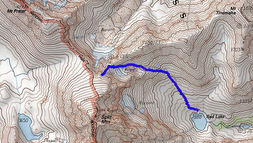
Getting to the Red Lake trailhead is half the challenge.
A nice page at climber.org describes an official route via McMurray Meadows Rd, and a shorter unofficial route through Tinemaha Campground and across private land near a pit mine. When we picked up our permit in Bishop, one ranger told us to take the Tinemaha road, but he was overruled by a second ranger. The leaflet they give you for the Red Lake trailhead specifically asks you not to take the Tinemaha road, so we followed the McMurray Meadows Rd route.
I'd heard the road was bad. But let me tell you, the road is REALLY BAD. It starts out well enough on a decent dirt road, but eventually it degrades into a boulder field hemmed in by thick brush on both sides. Huge pointy chunks of rock sticking up everywhere. I took a 4WD Subaru Outback with 8.5 inches of ground clearance, and while I didn't get hung up on any rocks, I did heavily scratch both sides of my car from the encroaching brush. I averaged less than 5 MPH over the last couple miles of the road, and even so the car bounced around violently like a carnival ride. I've driven some pretty bad roads in the past, but this one was by far the worst. By the end, my car looked like someone had keyed it a dozen times on each side:

Just as we arrived at the trailhead, we met a solo hiker who was leaving in frustration. He said he'd spent three hours bush-wacking, but the trail seemed to give out in the trees somewhere and he finally just gave up. In retrospect, he probably just started at the wrong spot. The trail begins a short distance north of the parking area, at a spring, and then proceeds up a dry hillside with no trees. There's a tempting trail-looking thing from the parking area into the trees right along the creek, but that's the wrong way to go.
The Red Lake trail is in pretty bad shape, and I didn't enjoy the hike up to the lake at all. The first several miles were in full sun with zero shade relief, with nothing but scrub brush for scenery, and it reminded me more of typical Los Angeles hillsides than the High Sierras. The trail is partly or completely overgrown in spots. Where it ascends a steep section, instead of having good switchbacks, it mostly just goes straight up a loose sand and gravel slope. I'd read about this ahead of time, but I was unprepared for how it affected me mentally. I wasn't too tired and the altitude didn't seem to bother me, but I was just grumpy and irritated over the poor hiking experience. After a few hours we reached a section with more trees and somewhat better trail conditions, which helped. We reached Red Lake mid-afternoon, after more than five hours of hiking, which seemed impossibly slow for what's supposed to be a 5 mile hike. The lake itself and the surrounding area was very nice, and we had it all to ourselves.
The next morning, we began our ascent about 7:15 AM. Just as we started, we bumped into two guys from San Diego who were doing the climb as a day hike, and had started from the trailhead at 3:30 AM. They stopped for a rest at the lake, while we began our slow hike up the boulder field above. It was slow going with lots of rock-hopping, but it wasn't especially steep or difficult. After an hour or so, we reached what we'd initially thought was the ridge bordering the North Slope, but it was just a saddle marking the entrance to a rocky moraine and a steep valley leading to the actual ridge.
Snow filled the bottom of the valley. At first we intentionally detoured around it on the rocks above, but we later hiked into the snow and found it was easier there. We didn't have any snow equipment, but the snow was soft and not too steep, so I wasn't worried about slipping and falling there. But as we climbed, the slope grew more and more steep, and we eventually exited the snowfield back onto the rocks.
At this point, we were uncertain how to best reach the ridge and the North Slope. The ridge stretched all across our path ahead, but it wasn't obvious which section of the ridge we should climb towards. From looking at the map, I believed that anywhere we reached the ridge, we'd pop over it onto the relatively more level and easy North Slope, from which point it would be a straightforward walk to the summit. We saw what looked to be a VERY steep and scary snow-filled chute, leading left up to a point high on the ridge, but assumed that couldn't possibly be the route. It turns out it was, but we didn't realize it. We hiked straight ahead towards a notch at the low point on the ridge.

I was still feeling pretty good, and while my friend wasn't moving very fast, he was doing OK too. As we climbed toward the notch, the slope grew ever steeper. Nearing the notch, I got excited and put on a small burst of speed to reach the top. I expected to scramble through the notch and stand on the North Slope with arms raised in victory. But just a few feet from the notch, I suddenly stopped short and saw that it didn't reveal the North Slope, but a yawning drop down a near cliff into some unknown valley thousands of feet below. I froze in place, terrified. I was lost, sitting in a notch on the ridge with vertigo-inducing drops on both sides. Many other people probably wouldn't have thought it was a big deal, but I'm a wimp and I was terrified, and my heart rate went through the roof. I was afraid to even move.
When my friend reached me, we took a breath, consulted the map again, and concluded that the correct route must have been the crazy steep snow-filled chute, now off to our left. I was pretty unhappy, and we discussed turning back, but after a while we decided to continue on and see how it went. We traversed across and up some loose rock until we were in the chute, at which point the San Diego guys re-appeared seemingly out of nowhere, just a short distance below us.
Now we get to the part of the story with the falling rock. The chute was steep, and I wasn't comfortable hiking up the snow in the center without crampons or an axe, so we skirted the snow on the rocks to the right. It started to get really steep. I stink at estimating angles, but from looking at the topo I'd say it was at least 45 degrees, and I saw one trip report that estimated it was 60 degrees. This was not class 2, but I didn't see any easier route up.
It was now hands and feet climbing on loose piles of junk, while my trekking poles dangled useless from their wrist straps. Everything was loose and good footholds were scarce - seemingly everything I stepped on slid out from under my feet. I grabbed ahold of larger boulders where I could, to stabilize myself, and pull myself up to the next rock step. Finally we were no more than 50-100 feet from the ridge. I reached up for a large rock slab just above my head, wrapped my hands around its edge, and tried to pull myself up. In horror, before my eyes I saw the whole chunk of granite pull out of the cliff face above me. Handhold gone, I flipped over backwards and fell as the granite tipped down onto me, and I had just an instant to think "this is going to be really bad."
Fortunately, it was not that bad. The rock and I slid and fell together for maybe 10-15 feet. It pinned my leg from the knee down, while my body twisted around backwards, causing some knee and ankle twisting. But then it slid off me, and came to a stop before reaching my friend, who was climbing directly below. I came to rest facing uphill, just above him. Both my trekking poles had collapsed, and I was scraped and scratched. For a moment I thought something in my leg was broken, but after a few minutes the pain receded and I was OK. My ankle and knee hurt, but otherwise I was mostly unscathed. After a few minutes to reflect on our near miss, we took this photo of "Death Rock":

After collecting our wits, we took the hint and began to descend to Red Lake. Thanks to adrenaline and ibuprofen, I was able to hike back down and out under my own power. I don't like to think what the rescue options might have been there if I'd broken the leg. It could have turned out very badly.
I'm a little disappointed I didn't reach Split's summit, but given the circumstances there wasn't any alternative. With the horrible road and poor trail to Red Lake, there's no way I'll be attempting Split again from that direction. Maybe someday I'll try Split coming from the John Muir Trail to the west, which is a much longer hike in, but is supposed to be a substantially easier climb.
For the curious, here's the route we took up from Red Lake. You can see where we climbed up the wrong way to the notch revealing a scary drop off into the canyon to the north: