|
0 members (),
111
guests, and
181
robots. |
|
Key:
Admin,
Global Mod,
Mod
|
|
 Mt Tyndall...is there a true class 2 route ???
|
Joined: Feb 2011
Posts: 46
|
OP

Joined: Feb 2011
Posts: 46 |
Hello to all out there, i just wanted some information regarding the various routes to the top of Mt Tyndall. I am thinking of taking the "North" route to Mt Whitney, from Shepherd pass. I have seen a number of hikers describe the different routes, and it is my understanding that the northwest route is considered a class 2 route. Can someone clarify if this is really true?? Let me explain (my) version of a class 2 route. Mt Dana, over all the broken rock, up to the summit , in the upper part of the mountain, on the north west side, is my interpretation of class 2. The last section of Pyramid Peak in desolation wilderness, is class 2,not the east route, but the south slope. I really do not want to have to deal with class 3 or 4 , where it involves rock climbing type terrain.
I plan on doing my trip, in either june or possibly early to mid August. If anyone can shed some light on this, and advise it would be greatly appreciated. I thought it would be great to summit Tyndall as well as Mt Whitney in the same backpack trip. Thanks to all who can provide a response. Eric.
"With each failure, you take another step towards success as long as you don't ever give up"
|
|
|
Re: Mt Tyndall...is there a true class 2 route ???
|
Joined: Sep 2009
Posts: 8,538 Likes: 107
|
|
Joined: Sep 2009
Posts: 8,538 Likes: 107 |
It has been a very long time since I summited Tyndall, but if I recall correctly, there was nothing difficult about it. We went up the north side, directly accessible from Shepherd Pass. At first, I thought comparing Mt Tyndall to Mt Dana is a pretty good estimate. But, when looking at both on the on-line maps, and converting the Tyndall map's meters to feet, it appears that the way up Tyndall is much more elevation change in the same distance. So from that standpoint, it might be more difficult. But... it was still NOT a difficult route. The only thing I remember about it is losing my nalgene water bottle down the steep north east snow slope. We spent a night at Shepherd Pass, climbed Tyndall in the morning, and then moved our packs down to Lake Helen of Troy (only a mile, but I recall it was rough). We then climbed Mt Williamson the same day -- it's short class 3 - 4 crack was memorable. We spent the night by Lake H of T, in the worst wind storm I have ever endured outdoors. We had planned on then moving south over the 13000' ridge to Mt Barnard, Mt Russell, and Whitney, but after that wind storm and other issues, we bailed. We sure set some pretty ambitious goals way back then!
|
|
|
Re: Mt Tyndall...is there a true class 2 route ???
|
Joined: Feb 2011
Posts: 46
|
|
OP
Joined: Feb 2011
Posts: 46 |
Wow Steve, that really is an ambitious goal!! I just can't help, wanting to hit as many peaks as I can while out there. I have failed twice already to reach the summit of mt whitney, and I am very determined to succeed this time. I just may give it a go for Tyndall on the way to Mt Whitney this time around. I summited pyramid peak over in desolation wilderness, right before christmas, and it was great. This year, it looks like it may be about the opposite as last winter as far as snow accumulation, but i guess we'll see. Thanks for the post,
"With each failure, you take another step towards success as long as you don't ever give up"
|
|
|
Re: Mt Tyndall...is there a true class 2 route ???
|
Joined: Jan 2010
Posts: 1,034
|
|
Joined: Jan 2010
Posts: 1,034 |
What does the south side of Tyndall look like? I'm in the middle of putting together a custom "high route" for the summer and after coming over Junction Pass, we'll be at Shepherd Pass below Tyndall. With the "easy" slope up in front of us we'd love to do a traverse to lake 3645 on the other side. Bob Burd has a trip report online that suggests that "in fact a climb from the Wright Lakes Basin to the south only rates class 2", but he was headed to Vermeer so there aren't any photos to show details of that south route. We'll be there with large packs having come from Yosemite and no real interest to do technical stuff. Reading his report, it seems that the route may be harder than class 2. Here's a map and his story from that trip: http://www.snwburd.com/bob/maps/tyndall_1.htmlI feel the easy route down probably drops down from the summit much earlier than he did, so the sketchy class 4 stuff he encountered may not be part of the normal route. Our plan is to head from Tyndall's summit south down to Wright Lakes, from where we'd head down to the JMT, but we'll only take on Tyndall if I we can get down the south flank without any major obstacles. This is the best image I have found so far showing the side of Tyndall we'd have to descend, but other than the slope angle, I can't really make out any details: http://www.snwburd.com/bob/trip_photos/barnard_1/DSC00030_w.html
|
|
|
Re: Mt Tyndall...is there a true class 2 route ???
|
Joined: Sep 2009
Posts: 8,538 Likes: 107
|
|
Joined: Sep 2009
Posts: 8,538 Likes: 107 |
If you can get up the north side of Tyndall with big packs, getting down the south side will be a piece of cake. Open these two maps in separate windows, and compare the two, both with the t4 contours, and Satellite. South side of Tyndall is similar to some of the west side part of the Whitney Trail. Rocky, but doable. Tyndall Map Whitney Map
|
|
|
Re: Mt Tyndall...is there a true class 2 route ???
|
Joined: Nov 2009
Posts: 582
|
|
Joined: Nov 2009
Posts: 582 |
I've heard the western (NW?) chute is Class 2, but that the route-finding at the top is a bit tricky, and can lead to Class 4+ terrain quickly. 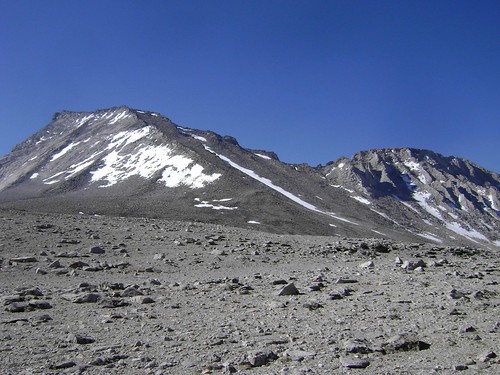 The North Ridge is mostly Class 2, with just a few Class 3 moves to get to the summit ridge. It's been a couple years for me, too, but here are pics of the route.
|
|
|
 Re: Mt Tyndall...is there a true class 2 route ???
|
Joined: Nov 2009
Posts: 161
|
|
Joined: Nov 2009
Posts: 161 |
Peter,
you might consider taking the Rockwell Pass from Tyndall Basin into the Upper Wright Lakes Basin. From there you go up Mt Tyndall. It has been over 50 yrs, but I climbed Tyndall from the upper Wright Lake and do not remember any serious problems as it was indeed a Class 2 climb. You mention climbing down Tyndall south ridge to Wright Lakes and then to JMT. By going over Rockwell Pass you could leave the heavy packs at your campsite and go up the SW ridge with only a day pack and return to your camp. From there you would continue down to JMT. This would avoid carrying heavy packs up Tyndall and still keep you on your intended route to JMT.
|
|
|
Re: Mt Tyndall...is there a true class 2 route ???
|
Joined: Jan 2010
Posts: 1,034
|
|
Joined: Jan 2010
Posts: 1,034 |
Peter,
you might consider taking the Rockwell Pass from Tyndall Basin into the Upper Wright Lakes Basin. From there you go up Mt Tyndall. It has been over 50 yrs, but I climbed Tyndall from the upper Wright Lake and do not remember any serious problems as it was indeed a Class 2 climb. You mention climbing down Tyndall south ridge to Wright Lakes and then to JMT. By going over Rockwell Pass you could leave the heavy packs at your campsite and go up the SW ridge with only a day pack and return to your camp. From there you would continue down to JMT. This would avoid carrying heavy packs up Tyndall and still keep you on your intended route to JMT. That certainly is an option. The camp site location will be a matter of when we get there. Tyndall is a bit rough for what I would want to do with two teenagers in tow, but at that point of the trip we should be pretty well aware of what our limits are, given we'll be traveling cross country for much of the Sierra crest before we get there. I need to start another thread for our route, since I need to pick some brains about some route segments I am contemplating.
|
|
|
|
|