|
0 members (),
259
guests, and
5
robots. |
|
Key:
Admin,
Global Mod,
Mod
|
|
 December wind storm: Trees on the JMT
|
Joined: Jul 2011
Posts: 36
|
OP

Joined: Jul 2011
Posts: 36 |
I was just at the summit this past fall and the door to the summit hut was still on (I think). Why is it off? We are heading back up this spring..
Last edited by Steve C; 05/31/12 03:50 PM. Reason: Change title
|
|
|
Re: December wind storm
|
Joined: Sep 2009
Posts: 8,538 Likes: 107
|
|
Joined: Sep 2009
Posts: 8,538 Likes: 107 |
> the door to the summit hut was still on (I think). Why is it off?The monster wind storm December 1 blew it off. Winds on Mammoth Mountain pegged the anemometer at 150 mph for six hours. View the graph in this post.Inyo National Forest reports major damage from downed trees all over the Sierra from that storm. See this post: Major Sierra tree troubles this year
|
|
|
Re: December wind storm
|
Joined: Jul 2011
Posts: 36
|
|
OP
Joined: Jul 2011
Posts: 36 |
|
|
|
Re: December wind storm
|
Joined: Sep 2009
Posts: 8,538 Likes: 107
|
|
Joined: Sep 2009
Posts: 8,538 Likes: 107 |
Here is a view of the Mammoth Mountain summit wind gauge from Dec. 1, 2011. It covers the 24 hours after 3 PM Nov 30 to 3 PM Dec. 1.  And the thread where DMatt reported: Major Wind Yesterday in the Eastern Sierra
|
|
|
Re: December wind storm
|
Joined: Sep 2009
Posts: 8,538 Likes: 107
|
|
Joined: Sep 2009
Posts: 8,538 Likes: 107 |
|
|
|
Re: December wind storm
|
Joined: Nov 2009
Posts: 56
|
|
Joined: Nov 2009
Posts: 56 |
Inyo National Forest has a web page showing some of the damage: . . . snip . . . 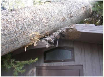 . . . snip . . . I don't imagine it's too often that they get their cement outhouses damaged like that! Think if it had been fiberglass or wood construction!?
|
|
|
Re: December wind storm
|
Joined: Sep 2009
Posts: 8,538 Likes: 107
|
|
Joined: Sep 2009
Posts: 8,538 Likes: 107 |
|
|
|
Re: December wind storm
|
Joined: Dec 2009
Posts: 558
|
|
Joined: Dec 2009
Posts: 558 |
It sucks the bath house was damaged because it was already closed last year and this will give them a reason to keep it closed this year also.
|
|
|
Re: December wind storm
|
Joined: Sep 2009
Posts: 8,538 Likes: 107
|
|
Joined: Sep 2009
Posts: 8,538 Likes: 107 |
Inyo has a web page on work progress for the cleanup.: Wind Storm of November 2011And here's a link to " Work Progress Details" A picture from the Work Progress details " This worker is actually standing on a trail" 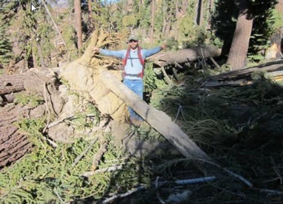
|
|
|
Re: December wind storm
|
Joined: Sep 2009
Posts: 8,538 Likes: 107
|
|
Joined: Sep 2009
Posts: 8,538 Likes: 107 |
I received this update a few days ago: Inyo National Forest Blowdown - Late Spring 2012
Key Messages and Talking Points
(Updated 5-25-2012) Current Situation- On November 30 a powerful windstorm hit the Eastern Sierra wreaking havoc in some areas of the Inyo National Forest, with estimates of over ten thousand trees being uprooted and downed. The Reds Meadow Valley, Devils Postpile National Monument, and trails leading into the surrounding Ansel Adams and John Muir Wildernesses were impacted the most.
- Good progress is being made in clearing downed trees from trails and campgrounds, and repairing damaged roads. Crews are working as fast as they safely can, but as of Memorial Day weekend there is still no projected opening date for public access to Reds Meadow Valley.
- Our goal remains the same as it has been - to open as much of Reds Meadow Valley, and the trails leading out of it, as soon as is feasible. Access to the Valley was gained over a month sooner than normal and crews have been working diligently to take advantage of the mild spring conditions.
- Despite the fact that this was a low snow year, there was approximately 200 inches of snowfall in Reds Meadow Valley. The ground is still very wet and this has impeded the work of crews and equipment that just cannot access certain areas.
- At this time no public access to Reds Meadow Valley is allowed, including pedestrian and bicycle traffic. The road has multiple potholes and breaks, and rocks and woody materials continue to fall on the road. Portions of area roads and trails are damaged to the point that they pose a hazard to the public until they can be repaired.
- The primary reason for the access closure is for public safety. There is a lot of heavy equipment working in the valley and on the road, and crews are working on the trails. Crews and heavy equipment operators are working in hazardous areas where knowing the location of every person is essential to maintaining safety. They are also able to work more quickly and efficiently when they do not have to worry about the safety of visitors who may be in the area. Allowing them to accomplish their work unimpeded by recreationists should facilitate the opening of the campgrounds and trails sooner, and reduce the risk of injury to public visitors.
- The Forest Service has suspended campground reservations in Reds Meadow Valley at this time. Wilderness reservations are still being taken for July and later in the summer, but we cannot predict the date that a specific trail will be clear. The temporary freeze on wilderness reservations for trails accessed by Reds Meadow Road will be lifted as soon as the road is open for public access.
- Even as trail obstructions are cleared, in some areas trail damage is significant. It may be many weeks until some trails are passable for all users, particularly for stock.
- It is anticipated that the first campgrounds to open will be Reds Meadow, Devils Postpile and Minaret Falls. The last to open will be Soda Springs and Agnew.
- In the Mammoth Lakes Basin, portions of which were also hit hard by the wind event, some trails still have minor obstacles. Duck Pass has not been cleared and the Mammoth Pass Trail, past McCloud Lake, is impassable at this time. Other less affected areas of the Forest, including Whitney Portal, and North Lake and the Paiute Pass trail out of the Bishop Creek drainage, have been cleared and there should be no impacts to summer access.
- Up to date information, with details on clean-up progress, maps and photos, is available on the Inyo NF website at : http://www.fs.usda.gov/goto/Inyo/Blowdown
Impacts - A December survey of 45 miles of trail out of Reds Meadow Valley revealed that all 9 trails were obstructed to some degree; at least ½ of the 45 miles of trail surveyed were densely covered with down trees.
- The Pacific Crest Trail (PCT) and the John Muir Trail were both obstructed north and south of Devils Postpile. Other affected trails include Upper Rush Creek on the PCT, Fish Creek, Mammoth Pass Trail into Reds Meadow, and the River, High and Shadow Creek trails near Agnew Meadows. Additionally some trails in the Mammoth Lakes Basin, including the Duck Pass trail, and the Piute Pass trail near North Lake in the Bishop Creek Drainage were also impacted.
- All developed sites in Reds Meadow Valley sustained some level of damage. Agnew Meadows Campground was the worst hit, with Reds Meadow Campground also being hit hard. Soda Springs, Minaret Falls and Pumice Flat Campgrounds had lots of down trees. Pumice Group Campground is not too bad. Starkweather Lake area is OK, while Sotcher Lake area had a large amount of down trees all around it, but very little damage to facilities was sustained.
- Devils Postpile National Monument had office buildings damaged. Throughout the valley the following were damaged:
- 20 picnic tables
- 14 bear boxes
- 4 fire rings
- 4 toilet buildings (2 seriously damaged)
- The work that needs to be done to clear developed sites and trails is multi-layered. Down trees must be removed. In the many cases where the whole rootwad was unearthed it must be dealt with and the hole left by the unearthed rootwad has to be filled in. It is estimated that there are around 400 rootwads that need to be removed and the holes filled within campgrounds and developed recreation sites in the Valley. Hazard trees (those that have not fallen, but have the potential to) are being identified and depending upon their location must be taken down. Damaged infrastructure is being repaired.
|
|
|
Re: December wind storm
|
Joined: Sep 2009
Posts: 8,538 Likes: 107
|
|
Joined: Sep 2009
Posts: 8,538 Likes: 107 |
This was published today from Inyo National Forest: We have an alternate route open for PCT hikers that need to resupply at Mammoth Lakes.
Please direct people to use the "Red Cones - Mammoth Pass" trails to get into town for supplies, and return to the PCT the same way. Attached is the trail sign that is posted on the PCT trail junction.
The saw team from Placerville did an amazing job of cutting through the some of the most complex piles. This area had 300 to 400 trees down in the section between McCloud Lake and the PCT junction! Here's the map showing Red Cones and Mammoth Pass. Full screen linkHere is the trail sign:
Attention PCT Travelers:
The Pacific Crest Trail from here to Red's Meadow as well as the trail to Horseshoe Lake from here has been cleared since the windstorm. The roaded portion of the Red's Meadow Valley including the road to Minaret Summit and Mammoth Lakes is closed to the public at this time until clean-up work has been completed. PCT travelers may stay on the trail through the valley but are not permitted to hike on the road out of the valley to get to Mammoth Lakes. The trail to Horseshoe Lake leads to a trailhead in the Mammoth Lakes Basin which is connected by paved road to the town of Mammoth Lakes. This is the best access point for PCT hikers to re-supply in Mammoth Lakes and return to the trail. Local bus service between Mammoth Lakes and Horseshoe Lake will begin on June 30th. Red's Meadow Resort is closed at this time as well as all Forest Service campgrounds. There are no services available in the Red's Meadow Valley. For more information contact the Mammoth Lakes Welcome Center at 760 924-5500. Thank you for your cooperation.
|
|
|
Re: December wind storm
|
Joined: Nov 2009
Posts: 908 Likes: 2
|
|
Joined: Nov 2009
Posts: 908 Likes: 2 |
|
|
|
Re: December wind storm
|
Joined: Oct 2009
Posts: 742
|
|
Joined: Oct 2009
Posts: 742 |
I will be in Red's Meadow Valley towards the end of this week, involved in a saw training class (guess there's no shortage of trees to cut!), and it will be interesting to see how things are looking.
|
|
|
Re: December wind storm
|
Joined: Sep 2009
Posts: 8,538 Likes: 107
|
|
Joined: Sep 2009
Posts: 8,538 Likes: 107 |
Here's an Inyo N.F. update, June 26, 2012 Hi everyone, Were getting ready to open the road soon. The shuttle will be ready to run starting on opening day. We are trying to open Friday June 29, HOWEVER… some emergency repairs to road equipment might still delay us, so don't promise anyone until you hear from a Forest Service source. - It is not guaranteed we will open on that date, or what time the bus will run.
- Parking is very limited in the valley, so backpackers need to use the bus.
Some of the trails are still in rough shape, please: - DO NOT direct people to Minaret, Beck or Fern Lake areas.
- Shadow Creek is clear to Ediza… But NOT clear on the JMT both north and south of Shadow Creek. (Do not issue loop trips using Shadow)
- Iva Bell -Fish Creek trail is not clear yet.. they are working on clearing it now.
- McGee Creek & JMT loop trips- the Tully Hole area has a big blowdown
Inyo N.F. Work Progress Report- June 25, 2012
|
|
|
Re: December wind storm
|
Joined: Sep 2009
Posts: 8,538 Likes: 107
|
|
Joined: Sep 2009
Posts: 8,538 Likes: 107 |
Pictures from Inyo N.F. Buried by Debris  Special thanks to all the work teams from other forests and partners that are helping with cleanup efforts to open Reds Meadow Valley in 2012. Hotshot crew walks to work  Hazardous Work  Sawing one will make the other logs roll  Stream restoration work will be needed  Flagging ribbon marks the trail location  Log stack blocks the trail  Traditional Handsaw Teamwork  Sawing team uncovers a trail...  Working deeper into the pile  Until they punch through.  Chainsaws are used where allowed  Leaning trees still hazardous after the sawing is done  Trails are being uncovered, section by section  Trail work is needed once the sawing is done  Opening Reds Meadow is a BIG JOB!  Thank You, Hotshots from Shasta-Trinity National Forest 
|
|
|
Re: December wind storm
|
Joined: Nov 2009
Posts: 582
|
|
Joined: Nov 2009
Posts: 582 |
Thanks so much to all of the crews for all of their hard work. The carnage across the Sierra is extensive, and conditions are pretty crazy. A word of caution to all those hiking: the trees are extremely dry and brittle, and branches -- even thick ones -- can snap without warning. Be careful climbing up or around these trees. Even on the westside this weekend, we were treated to hours of fun dodging the downfall: 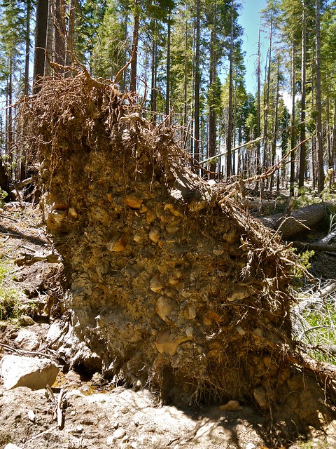 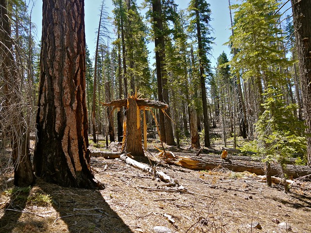  There's a trail under there somewhere: 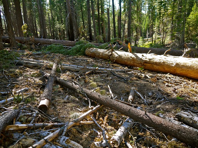 OUCH!!! 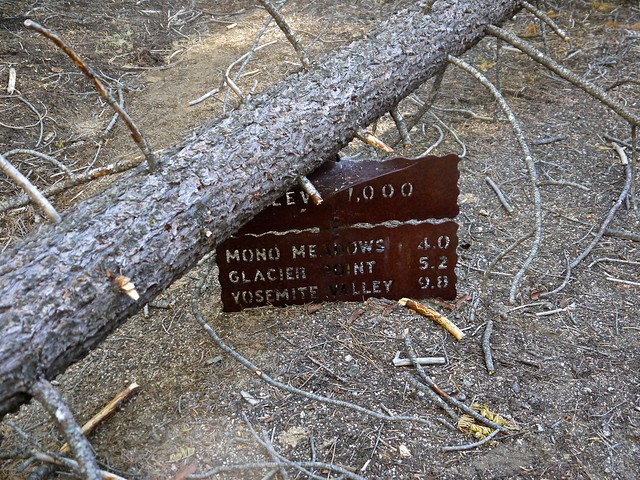 Take your time out there! -L
|
|
|
Re: December wind storm
|
Joined: Sep 2009
Posts: 8,538 Likes: 107
|
|
Joined: Sep 2009
Posts: 8,538 Likes: 107 |
I found this Ritter Range Circumambulation - blow downs!!!!!From Reds Meadow up to the crossing of King Creek there were four major blow down piles. From King Creek to Granite Creek, including the trail from Corral Meadow to Hemlock Crossing and down and west to Granite Creek there are at least 500 blow downs. I am trying not to exaggerate. The Sierra National Forest people have major work to do. For about 25 miles we spent as much time walking around and over blowdowns as on the trail. Once the trail jogged left in the middle of a 100 yard blowdown and we spent a half hour looking for it. From the 7500' to 8800' level blow downed tree piles are everywhere. No rhyme or reason - north slopes, south slopes, etc. Trees in this elevation band tend to be big, and when in piles, can be awesome - a giant's hand just knocked 20 of them down willy nilly. This route heads out of Devils Postpile (Reds Meadow), west over the crest between the San Joaquin's middle and north forks, entering Yosemite via Isberg Pass. They covered lots of little-used trail.
|
|
|
Re: December wind storm
|
Joined: Nov 2009
Posts: 595
|
|
Joined: Nov 2009
Posts: 595 |
This is a nit, but ... Am quite sure the high winds occurred on November 30th and continued into December 1st.
These dates are "burned" into my memory as the high winds (upwards of 90mph in the IWV) in the late afternoon of November 30th caused a power failure, which in turn caused my pellet stove to malfunction and cause substantial smoke damage in my home.
IIRC, there was another period of especially high winds in the Eastern Sierra about a week or so later, but they weren't as severe as the 11/30-12/1 storm.
Last edited by KevinR; 06/28/12 06:34 PM.
|
|
|
Re: December wind storm
|
Joined: Sep 2009
Posts: 8,538 Likes: 107
|
|
Joined: Sep 2009
Posts: 8,538 Likes: 107 |
This is a nit, but ... Am quite sure the high winds occurred on November 30th and continued into December 1st.
These dates are "burned" into my memory as the high winds (upwards of 90mph in the IWV) in the late afternoon of November 30th caused a power failure, which in turn caused my pellet stove to malfunction and cause substantial smoke damage in my home. You're right Kevin. I keyed "December" in the subject title based on the graph at the top from Mammoth Mountain. There, the storm began on Nov 30. But it peaked maybe midnight or sometime later. Too bad about the smoke damage. At least a pile of pine trees didn't crash through your roof! :| ....And more news from Inyo N.F. Hi everyone, Good news- the Reds Meadow Road is scheduled to open Friday, June 29 We are hearing from hikers about more areas with trees down: - 100+ trees down in Tully Hole area
- 50+ trees down on Mono Creek trail, west of Second Recess
- large number of trees down in Ansel Adams -Sierra NF-Reported as very difficult from Isberg Pass to Clover Meadow and the trail crossing to Reds Meadow via Summit Meadow.
- trees across the trail on JMT- Lyell Creek to Tuolumne Meadow.
|
|
|
|
|