Mt Whitney Webcam
Mt Williamson Webcam
Who's Online Now
0 members (), 207 guests, and 16 robots.
Key: Admin, Global Mod, Mod
Previous Thread
Next Thread
Print Thread
Whitney Trip Report 8/24/12
#27267 08/26/12 08:04 PM
Joined: Aug 2012
Posts: 3
K
Kerry Offline OP
OP Offline
K
Joined: Aug 2012
Posts: 3
Hello everyone, before I get started I want to thank everyone who has taken the time to share their strategies and wisdom with the group. I read through just about all of the topics and advice and I have to say it really helped out. That being said, I want to share my experience, covering all of the topics that I found so helpful in my research and preparation for this incredible hike. If anyone has any specific questions about my report or if I missed covering something just let me know.

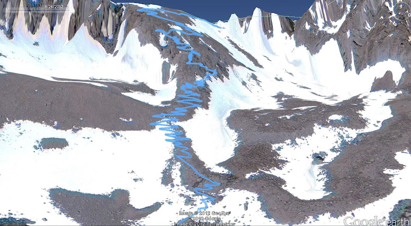
I dayhiked via the main trail on 8/24/12. I am 35/male, and am fairly new to hiking. My first hike was 22 months ago, although since that time I have done many 15-20 mile, 5,000 foot elevation gain dayhikes. Nothing above 4,500 feet until last month, however. (I live near the Bay Area, and had not gone to the Sierra until last month).

Altitude Training

In July, I progressively started upping my elevation, first up to 8,800 on Half Dome, two weeks later up to 9,900 on Cloud's Rest, then the following week up to 13,000 on Mt. Dana. No problems except for some difficulty catching my breath but it would always return after a minute or two of rest. All of those hikes were day hikes, drive up to Yosemite in the AM, drive home after the hike was over. My last time at high elevation was 2 weeks ago at Mt. Dana, where a hailstorm turned me around at 12,250 ft.


Permit


I secured my Whitney day permit about two weeks ago by continually monitoring the permit website, and finally got lucky when a permit was suddenly available.

Acclimation Plan


So for the week of the hike (Friday was the hike) - Wednesday I drove up to Yosemite, and hiked to the summit of Tioga Peak, at 11,500 ft. From the trailhead it is only a 1,700 foot climb over a little less than a couple of miles. Nothing too hard to wear me down, but high enough to get some acclimation. I brought a book up to the summit and read for a couple of hours, then hiked down and drove on to Mammoth Lakes where I spent the night at 8,100 feet (motels for me, I need to be comfortable to sleep).....

Thursday I drove the rest of the way south to Lone Pine, got my permit around 10 AM, and then drove straight up to Horseshoe Meadows at 10,000 feet. I made sure to not do anything too stressful, so I stayed between 10,000 - 10,500 feet, covering 7.5 miles. I kept up a decent pace with my pack on - a little faster than 3 mph and felt really good. I then read for another several hours before heading down to my motel in Independence, which is only 15 minutes away from Lone Pine. It is an easy drive between Lone Pine and Independence, just be aware that Independence does not have as many shopping options (e.g. no grocery store)as Lone Pine. No problem, they did have a Subway so I just bought a couple sandwiches rather than some food from a grocery store.

The hike:

This was a solo hike. I probably go solo 75% of the time, and I carry a lot of safety items (locator beacon being the most important in case of emergency). I was on the trail by 4:30 AM, summit at 11:15 AM, and was on the road back home before 5:30

Water


Drank 2 liters of Powerade zero in my car before heading off, carried an additional 3 liters with me, along with 2 empty liter bottles to hold more for the last fillup at the switchbacks. I drink a lot so I am not saying everyone needs this much, this is just what I have always found works for me. I also brought a UV filter (maybe unnecessary) and electrolyte packets to mix in with the water. I wound up filling one liter at the water source number 4 (http://www.ridgenet.net/~rockwell/Whitney_water_trail.pdf), the north slope of Candlelight Peak, then filled 3 more liters at switchback 23. On the way down I filled 2 more at switchback 23. This was enough to get me back down. I probably carried more than I needed most of the trip. All told, I drank 2 liters in the car, then 8 more on the hike.

Problems

No trail problems, no water problems, brought a couple thousand calories so I was okay there. Only slight altitude problems, but not until I was on the descent. I was feeling pretty tired, which wasn't all that surprising, but once I got back down to about 11,500 feet I had a huge burst of energy that had me flying back down so there was something there. No wild animal problems, no trail work problems. The only weather problem was I forgot my sunglasses and did sunburn one of my eyes a little bit. Nothing too serious and its fine now but was really sensitive to light for about 24 hours.

Conclusion

I had the time of my life, and can't wait to come back again next year. Thanks again to everyone who helped an anonymous board lurker put together what turned out to be a fun, safe, and successful summit bid. Tons of pictures if you are so inclined at https://picasaweb.google.com/107173209992743952243/MtWhitneyAugust242012

Re: Whitney Trip Report 8/24/12
Kerry #27270 08/26/12 08:35 PM
Joined: Sep 2009
Posts: 130
V
Offline
V
Joined: Sep 2009
Posts: 130
Thanks for your report. Aside from the sunglasses, it looks like you planned your trip well and got good acclimation.

Re: Whitney Trip Report 8/24/12
Kerry #27271 08/26/12 08:47 PM
Joined: Sep 2009
Posts: 8,507
Likes: 103
S
Offline
S
Joined: Sep 2009
Posts: 8,507
Likes: 103
Nice job, Kerry! Especially the trip report.

Your pictures of the hike profile and those from Google Earth are great. Including them here along with your captions for people to see:

So my Garmin GPS only has a 12 hour battery life - it died about 400 vertical feet from the end. So it looks like I did about 1 more mile than is shown here, I'll say it was 21.5 miles. Trail Crest is the slight downhill at mile 8.25, and Keeler Needle is the upward spike at mile 11.5.


Google Earth view 1 - the trail is so long that you can't really see any detail above the Trail Camp, so I did separate shots for those sections.


These are the 97 switchbacks above Trail Camp leading to Trail Crest.


And finally, the view from the western side showing the path along the western side of the mountain. You can see my side trip up Keeler Needle, with a different path down as well. All in all, a trip with enough memories to last a lifetime, or until I go back next year!

Re: Whitney Trip Report 8/24/12
Kerry #27277 08/26/12 11:54 PM
Joined: Aug 2010
Posts: 632
Offline
Joined: Aug 2010
Posts: 632
Kerry...congratulations on your summit. I am happy you mentioned your age in your trip report. I was younger than you by four years the first time I summited MW. My first summit consisted of spending two nights and three days along the main trail. I don't remember hikers going up and down the trail in one day back then...30 years ago...but maybe hikets did and I wasn't aware. Sometimes it saddens me to read how hikers zip through the wilderness like they're on a freeway. Your generation of trekkers make me think this sport of hiking mountains is going to change even more than it has...it is as if a new generation wants to move along the trails at the speed of a computer. I find it fascinating that you acclimated in what would normally be three beautiful destinations and not just a place to read a book for a few hours to become accustomed to a new elevation. I'm not knocking your trip report.....I'm noting that I see hiking taking on a new path....I hope you smelled the pines...saw some wildlife and heard water trickle through the streams on your journey. Thank you for sharing...bottom-line I think you are in much better physical and mental condition than I ever have been....I'm jealous...I hope to read more trip reports by you....


Lynnaroo
Re: Whitney Trip Report 8/24/12
lynn-a-roo #27281 08/27/12 08:16 AM
Joined: Aug 2012
Posts: 3
K
Kerry Offline OP
OP Offline
K
Joined: Aug 2012
Posts: 3
Thanks guys for your feedback. I wrote my trip report as more of an example of how to reach the top than an report of the actual journey - I do separate journals/photo albums for each trip (including Horseshoe Meadows at https://picasaweb.google.com/107173209992743952243/HikingHorseshoeMeadowsAugust232012 and Tioga Peak at https://picasaweb.google.com/107173209992743952243/TiogaPeakAugust222012), but your perspective is good to hear.

The outdoors is such a beautiful place and to only focus on the destination rather than the journey would be sad. I know I struggle to balance the two - I have always had a predetermined distance or summit to reach. Horseshoe Meadows was my first hike where I let myself choose whichever path I wanted, whatever distance felt right, and had no worries about what time it was or how much further I needed to get.

Not to get too far off topic, but my love of the outdoors is very new - as I mentioned in my report, I have been hiking less than 2 years, and that is because 3 years ago this was my condition https://picasaweb.google.com/10717320999...373078328063554 - I lost the weight the old fashioned way with diet and exercise. After dropping enough to where I could be somewhat active, I found hiking and fell in love with it. It was all about the physical challenge and the health benefits I desperately needed. Now that I have achieved a measure of better health, it is a constant struggle to balance the need to "get my exercise" with the pure fun and enjoyment of the journey. That drive allowed me to get stronger much faster, but it comes at the expense of missing some of the enjoyment of the journey. Anyway, thanks again for the feedback, it is much appreciated and a great reminder.

Re: Whitney Trip Report 8/24/12
lynn-a-roo #27286 08/27/12 09:24 AM
Joined: Aug 2012
Posts: 5
T
Offline
T
Joined: Aug 2012
Posts: 5
Lynn,
I also hiked to the summit on 8/16. This was my second time in two years and my first solo trip. I think I enjoyed being alone on the trail and I was more observant of my surroundings. I noticed the bear watching me in my head lamp at Lone Pine Lake and I didn't miss any of the wildflowers or cloud formations or the lakes or waterfalls. I am glad I made the trip alone and hope to do it again next year.


Link Copied to Clipboard
Powered by UBB.threads™ PHP Forum Software 7.7.4
(Release build 20200307)
Responsive Width:

PHP: 7.4.33 Page Time: 0.025s Queries: 26 (0.021s) Memory: 0.6055 MB (Peak: 0.6824 MB) Data Comp: Off Server Time: 2024-03-29 12:10:15 UTC
Valid HTML 5 and Valid CSS