I finished the JMT a week ago Wednesday, 49 years give or take a day or two after being snowed out at Trail Camp. That 1964 storm ended what was to be a two-week trip into the upper Kern and Kern Canyon and I have been trying intermittently to get back to that side of Whitney ever since. Two years ago, my family and I backed off of the HST below Kaweah Gap due to a really hairy snow bridge above Hamilton and undercut snow much of the rest of the way to the Gap.
This year, after 200 miles from Happy Isles, the weather was shaping up for another run at me. I had already hit a four-day system of t-storms just below Muir Pass, which kept me off of Mather for a day, and afternoon lightning and evening rain persisted until I had cleared Pinchot and Glen. After a couple more days of clear sailing, as I approached Bighorn Plateau going for Guitar Lake, a second system closed in before 9 AM. This one did not follow the pattern of the earlier system - earlier arrival, no electrical activity during the day - making it uncertain whether it would clear at night and early morning or just remain socked in for days to come.
As I approached Timberline Lake, the show was really starting. Intermittent rain was accented by occasional bursts of full sun, chilling wind, more and darker clouds, a rainbow and another spell of rain. At one point, a couple descending from guitar stopped and chatted as another squall moved in, compelling me finally to suit up with full rain gear. “Watch this”, I said, “I’ll make it stop raining”. They laughed and moved on, but within a minute after I was all buttoned up and battened down, the squall stopped, the sun shone briefly in the roiling clouds to the west and all was quiet again.
Not for long, of course; the temperature was dropping and more dirty-bottomed clouds moved up from the south over Hitchcock as I moved on toward Guitar. I arrived at Guitar during another pause between squalls, to find a couple dozen tents spread around the basin, and several groups and solo hikers setting up, fishing, heating water and just standing around chatting. This rolling, temporary community was spread over about a half square mile from down-canyon of the lake to the tarns just above.
Not immediately recognizing any of the most recent version of my trail family, I set about finding myself a really decent ledge, level and clear, near enough the lake and far enough from neighbors. As I was setting up, the next shower started; a fly caster ran from the lake, and in about 30 seconds, tents were zipped and not a soul was to be seen moving in the whole basin. That squall blew through in about 10 minutes, and I finished setting up in the interval before the next one rolled down from the ridge of Hitchcock and drove us all inside again.
Back at the Tyndall Frog Ponds that morning, as we saw the weather already building to the south, there was much discussion about how and even whether it would be possible to get over the Crest safely with another set of T-Storms moving in. I supposed that it would follow the same pattern as the system a few days before: afternoon t-storms and electrical light show, with hail of course, settling down to a steady evening drizzle, ending by midnight, rinse and repeat.
Meaning of course, that our best window would be between about 2 and 8 AM to get up and over the Crest, summiting only if it looked safe. At least that was Plan A. Plan B, of course, was that Plan A works perfectly.
Up to about 8 PM on Tuesday, however, this new system was not following the previous pattern: rain started too early in the morning, kept up too steadily all day, and was showing no signs of clearing by 8 PM. Looked like it would be safe, if unpleasant, to go over the Crest: no electrical activity, but not exactly an ideal summit day either. Oh, well, at least it would be safe. Kind of like the weather that Steve C summited in after his Pants Pass transit last year.
Just about the time that thought gelled, there was one single flash of lightning and a tremendous boom of thunder, very close. So much for the safe but miserable crossing of the Crest. Oh well, I hit the sack resolved that I would just go with the flow, even if it meant waiting out another 4 day system at Guitar Lake. There are worse places to be pinned down.
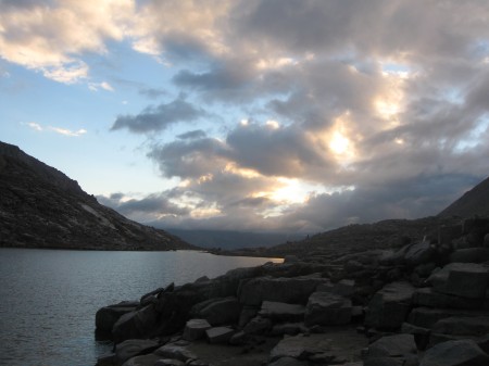
The light show at Guitar Lake
So I set my internal alarm clock for 2 AM, hit the Tylenol PM and dozed off, vaguely noticing there seemed to be no more rain after darkness finally fell.
Sure enough, I awoke about 2:20, carefully unzipped the tent, and looked up at one of those clear, cold, moonless skies full of the Milky Way that you only see in the high places. The moon (waning quarter) was not up yet, but even in the starlight I could see that the sky was not only moonless, but cloudless
Plan A was working perfectly.
Well, aside from the fact that it was also 25 degrees and blowing about 20.
As headlights came on all over the basin, they slowly formed a line of perhaps 20, strung out over a couple of miles up and down the approach and the switchers up to the Crest. The trail Family was on the move, more or less as one, but now connected only by the attenuated string of a few faint points of light, fractions, and halves and whole miles separating and joining them at once.
I hike slower that at least 90 percent of the people I meet on the trail. After three weeks, I developed endurance and wind beyond my expectations, but no speed to speak of. As a result, over the next couple of hours, most of the lights behind me passed me up somewhere on the switchers. Nearly every one of them was someone I had met , talked with, eaten with over the previous several days – my trail family. The thin, almost magical connection of the string of lights was confirmed by a brief greeting at each such passing, and then dissolved into a point of light ahead in the night. Each passing also left me a little warmer, stronger and more assured about the eventual success of this Alpine start we were all otherwise silently sharing.
It was the best morning of the trip.
I reached the MWMT junction just as the first rays of sun were peeking through the windows, and dropped my pack, marmot-ready, among a dozen or so that were already lined up there. I had a packable day pack with me, water, camera, snacks, essentials all set for the summit. One final check around confirmed only fair-weather clouds in sight: it was now 22 degrees and blowing about 30-35 steady with gusts certainly to 50, but it was clear, and the sun was up and coming: summit time.
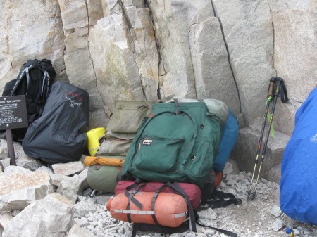
Old School packs at the junction. Those are my poles with the WHA Freak Flag, but my pack is to left center, the 1973 Kelty Tioga, not the 1978 Aplenlite nearer the foreground
Without my full pack (now around 34 lbs) I did put on some speed, and made the summit in under an hour. Or so it seemed. I wasn’t watching the time, just the weather, and I haven’t checked my SPOT track, but with the summit in sight, I felt like I was flying. The wind continued to build as I climbed the final 1.9 to the summit, and By the time I summited, it was knocking us all around pretty well. Not a leisurely rest at the summit rocks: even the resident Marmot King was nowhere to be seen. Most, including me, were taking a few hasty summit shots, making unrewarded attempts to get a cell signal from Lone Pine and heading back down. By the time I left the summit, the clouds flying over the Crest were getting bigger, darker and lower. The window was definitely closing.
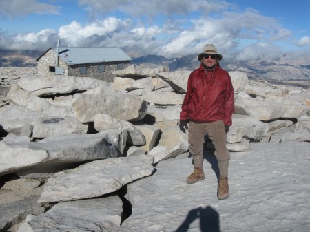
Summit shot, blowing like hell, the day's weather already building over the Kaweahs, time to get out of Dodge.
Got back to the JMT junction in record time (for me) as well. Not too much remarkable about that section. Took a few pictures, but nothing we haven’t all seen many times before. The one phenomenon worth noting, which I was not able to capture, was the incredible rate at which the clouds were no crossing the Crest: looking like a time lapse video of weather moving through the area on most days I recall, these clouds were probably moving at speeds approaching 100 MPH, just a few hundred feet above the summit. Winds were definitely gusting to about half that at 14,5 and steady at at least 30-40.
As I descended the 97, I began to notice that a larger and larger proportion of the hikers coming up seemed ill-equipped, some aware that they were in a little deep, and others not. People carrying no pack at all, no water in evidence, lightly dressed (boy were they in for a surprise at the Crest), no sun protection. Later, others in the trail family remarked on the same phenomenon. Although many were equipped to the gunwales, with the newest (and most) high tech stuff, many more seemed completely out of touch with where they were and what they were headed for.
Well, you can’t help everybody you think is in some kind of difficulty, but there are certain cases . . . . At about switcher 15, I encountered one of the more compelling types. A relatively young man (early 30’s: I am 63) was sitting by the trail, simply staring at his pack next to him, in what I recognized as something like shock. I set down a few feet away, and went through my trail rest routine: a little water, a little squirrel food, a little conversation: how’s the hike going etc. First words out of his mouth: “My pack is too heavy. I can’t believe it; my pack is too heavy. I can’t carry this”.
Long story short: JMT through hike, had started at the Portal at 4 AM on a 20 day itinerary, no resupply, he was carrying 20 days of food, trying to get to the summit and over to Guitar the first day. 16 miles, 6000+ and 3000 -. At 1 PM he just collapsed, a fraction of a mile past TC, mile 6. He couldn’t understand it, he said, he was in shape. Hiked every weekend, had done fourteeners on weekends, couldn’t understand why he couldn’t carry this pack.
How long have you been up here? Since this morning. No I mean, how long in the mountains, what did you do to acclimate?
(Get ready for it)
“What’s that?” he said. Direct quote.
“Acclimation”, I said. “Or acclimatization, you know, getting conditioned to the elevation”. He just repeated what he said about hiking on weekends, getting some fourteeners in, being in shape.
No I mean on this trip, when did you start, where have you spent the past few days.
“Oh, I drove up from Orange County last night: started at the Portal this morning”.
Aha. He actually had no idea what I was talking about and had a hard time grasping the concept: I was apparently introducing the idea of acclimation to him.
I didn’t advise him to do anything: just told him what I would do in his situation. Go back down to Trail Camp and enjoy it for a couple days, maybe run back down to LPL or Outpost for a little exploration, then see how the pack felt in a couple days.
Food and time were a consideration. Not a problem, says I. If I could do it in 20 days, I could find a way to do it in 18. Also made a couple of suggestions about resupply, also a new idea for the guy.
Don’t know what became of him, but about 20 minutes later, as I was talking to some new trail family at TC, down he comes to set up, apparently for that couple of days. “I tried to go up, but I think I like your idea”. So he set up and unpacked, revealing a very full BearVault and two almost equally large poly bags of additional food. Which he left out while he found a spot behind a rock. Needless to say, when he came back, there was another introductory discussion, Marmotry 101. Turned out that another hiker I met n Lone Pine had stopped to confer with him and hour before I did. gave him Pack Weight 101. I hope things turned out better for him than they started off.
The guys I was talking to at TC turned out to be a film crew from CalTrout doing a documentary on the elusive pure strain of golden, looking everywhere for it. One of their pro anglers, George, was the one I had seen at Guitar the night before, running for cover (“I almost passed out from that!”) as a squall moved in the night before. Craig the gang leader, who looked to me like the Old Man of The Mountains, had me hold for a couple of pictures, because, he said, I looked like the Old Man of the Mountains. Hmm, no wonder Kendall, the solo female hiker back at Forester told me, on the several occasions when our paths crossed, that her friends were catching up to her. I told her later in Lone Pine that I thought hers was a good strategy. (After I got to the hostel in Lone Pine, I showered, shaved and did some laundry, and so managed to spend a day there without getting arrested for stalking, general public nuisance, or anything else).
So after becoming fast friends with the film crew, I pounded down the rest of the main trail, again passing a disturbing number of apparent shock and misinformation victims. I did happen to notice no evidence of the horror stories I have read here of conditions at Trail Camp and elsewhere. I did not see one WagBag out of place nor see or smell any evidence of sanitary or other abuse of the trail. Nor did I see any evidence of official patrol or enforcement although some did later tell me they got carded by the trail crew chief we all saw down below LPL.
Was this just the odd lucky day, or have things improved?
Portal/Store
I had forgotten in 20 years that the 97 is not the only challenging set of switchers on the trail. For some reason –selective memory – I had the idea that the log crossing was just up the trail a fraction from the North Fork crossing. Descending from the logs, however, was areal challenge to my patience with myself and the Zen of switchbacks I had developed over the previous 221.9999 miles. For the entire time warp (probably of less than an hour) the Portal was like the background in one of those Spike Lee zoom shots where the foreground is whizzing past all around and the background seems to actually get farther away. You know?
Suffice it to say, the time warp was finite and served to make that bacon cheeseburger, and the company, at the Portal Store, the finest dining experience imaginable.
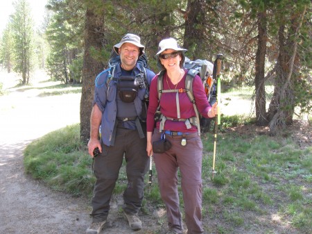
Trail Family and others
I want to mention here a few really special people I spent the last few days running into and hanging out with.
Carl and Natalie. Natalie had hiked the 221.9999 miles without incident, but turned an ankle somethere on the final descent below Outpost. Ouch, but hiked on out and both were at the Portal Store when I came in. Simply overhearing a conversation I had there, they offered me a ride to town before I could even put my thumb out, so I enjoyed their highly enjoyable company all the way down to the Hostel where they not only dropped me off, but carried by pack in for me. Leaving my poles in the back of their truck seems a small price to pay for the privilege. Maybe if they read this, I’ll get them back on my next trip out there. I think they are from the Bay Area.
Nick & Marissa. What a day they had. Met them in the Laundromat, the center of social activity in downtown Lone Pine, the day after my summit. First place they went while waiting to check into the Dow Villa, across the street from the Hostel. They had started their day by arriving at the summit about 3 am to find a day hiker from the day before, huddled, shivering, hypothermic, in the hut. The hiker apparently was only in the early stages of hypothermia, because they wrapped and revived him and he was apparently able to walk down a little later, but it being 3 am he had probably not been long from serious trouble when they found him.
Oh, yeah: A little later, as the sun broke over the Inyos, Nick proposed to Marissa, and presented her with the ring he had been carrying for 210 miles. Accepted.
After they descended, about the time I met them, Nick and Marissa learned that their hike was not over. Their car was in Yosemite Valley and unreachable by the bus route they were counting on. Tioga Road was closed due to the Rim Fire, and they were looking at taking the bus to Tuolomne and hiking down 24 miles to their car. They didn’t have the Tom Harrison maps, however, to see whether there was another way of the JMT itself.
All this before breakfast.
A little later, I looked at mine and found that the hike to the valley from Olmstead is only 12 miles, without the climb out of Tuolomne (1500 ft) much more direct and downhill, and relatively easy day hike. So I dropped my maps and notes at the Dow Villa, with the beta that the Tuolomne shuttle was still running as far as Olmstead.
Learned yesterday that they had made it by that route back to their car in fine shape.

Nick and Marissa.
Andy. Roommate at the Hostel, research grad student at Berkeley, into purifying pathogens, had a lot to talk about in common.
Alex. New Harvard lawyer on his way to Phoenix to start first law firm job. I first met Andy, Alex and Aaron below Forrester, looking up at what we thought was the pass, but was only an intermediate ridge. That is one big mother bear of a pass. I suggested casually to Aaron, who was hiking a lot off-piste, that the direct route might go. Five minutes later, Aaron was off on that approach, and sure enough, the route went. The Forrester Direttissima, if you ever want to try it, goes from the meadow at about 11,5, about due south, and meets the last traverse to the final switchers just to the west of the big round buttress. Alex is going to do the Camino de Santiago before actually reporting for work. I can see the intake interview. “So what have you been doing for 6 months to prepare for your career here at Dewey Cheatham?” “Walking.”
Yani, the clerk at the Hostel. She had been a PCT through-hiker in June, had come over Trail Crest to resupply, and took the job at the Hostel instead. Working her way back to Argentina. Now that’s a class act.
Charlie. Another roomie at the Hostel. Finished the PCT, returned to do the JMT again SoBo, and went back up back a final time to day-hike Whitney. A hiking animal, started the JMT by day-hiking from the Valley to Tuolomne. That’s 24 miles with a 6000 ft climb, net, and two descents of about 1000 and 1500. Tough 3 days for me, but then again Charlie’s base weight is 6, count em, 6 lbs. Less than my summit day pack.
Bulldozer, Steam Roller and Tequila Sunrise. 3 young ladies who kicked my ass at mileage, endurance, and pizza consumption.
Slate “Old Milwaukee”. Hasn’t been everywhere, but its definitely on his list.
Akichow. This was special. As I made my way up Lyle Canyon on day 4, I heard behind me "Hey, are you flying your Freak Flag?" Second time in 3 days I had heard a recognitioin of my green ribbon (the first time, just above Nevada Fall, somebody was moving down so fast I didn;t have time to react and make contact: I wonder who that was.) what a delight it was to meet Akichow and her hiking buddy! And to give her a length of Freak Flag to fly on her own.
Akichow and friend, flying her new Freak Flag
Lone Pine
I really like the town. Thursday morning I became a citizen. Went to the post office to pick up my bounce box from Yos. (It was there, intact) Asked Veronica where the best breakfast was. “You going to breakfast? Listen, you go over to the Alabama Hills [Café], and while you’re there, you tell Gilbert that Veronica is still waiting on her dam burrito, ok? He’s my ex-boyfriend, but we’re just friends now, and he owes me that burrito.”
Message delivered (but not the burrito: Gilbert was off). Great breakfast. Best Mexican food recommended by Yanni (pronounced zhannie, btw) is definitely the Taco Truck, parked on a corner lot a couple blocks east of the light (there are street names in LP, but it’s a lot easier to give directions in terms of the light) . Great food and company, real Mexican Coca-Cola (sugar, no HFCS) and open till 11.
So Friday, ESTA to Reno, Amtrak all the way to Boston.
What a ride!