Mt Whitney Webcam
Mt Williamson Webcam
Who's Online Now
0 members (), 121 guests, and 3 robots.
Key: Admin, Global Mod, Mod
Previous Thread
Next Thread
Print Thread
Tulainyo Lake to Arctic Lake
#34945 01/19/14 11:37 AM
Joined: Jan 2014
Posts: 1
D
DylanK Offline OP
OP Offline
D
Joined: Jan 2014
Posts: 1
Looking to make a detour to end my JMT hike this summer. Question: if I follow Wallace Creek from the JMT to Tulainyo Lake, is it possible to cross the west ridge of Mt. Russell and drop down to Arctic Lake, and to Guitar Lake and Trail Crest? Unclear from topos if there is a route there, or if I would have to take the Russell-Carillon col and the mountaineers route or backtrack to the JMT.

Re: Tulainyo Lake to Arctic Lake
DylanK #34947 01/19/14 12:57 PM
Joined: Sep 2009
Posts: 8,505
Likes: 103
S
Offline
S
Joined: Sep 2009
Posts: 8,505
Likes: 103
Interesting that you would ask that, Dylan, since I was thinking about trying that summer before last. I hiked part of the High Sierra Trail route with a Pants Pass detour, and wanted to try fishing Wallace Lake, since I'd heard there could be some good fishing there. Someone also told me he was sure Arctic Lake would have good sized fish, so I wanted to fish that one, too. I spent a lot of time staring at the contours of that ridge crossing trying to convince myself it was possible. It is a big clue, though, that RJ Secor does not mention a route across that pass. (He also says the north side of Whitney is climbable, which I was hoping to try, but then I realized the only reports I'd seen were of climbs made in snow -- Crampons and ice axe make really steep slopes climable, that otherwise are not.)

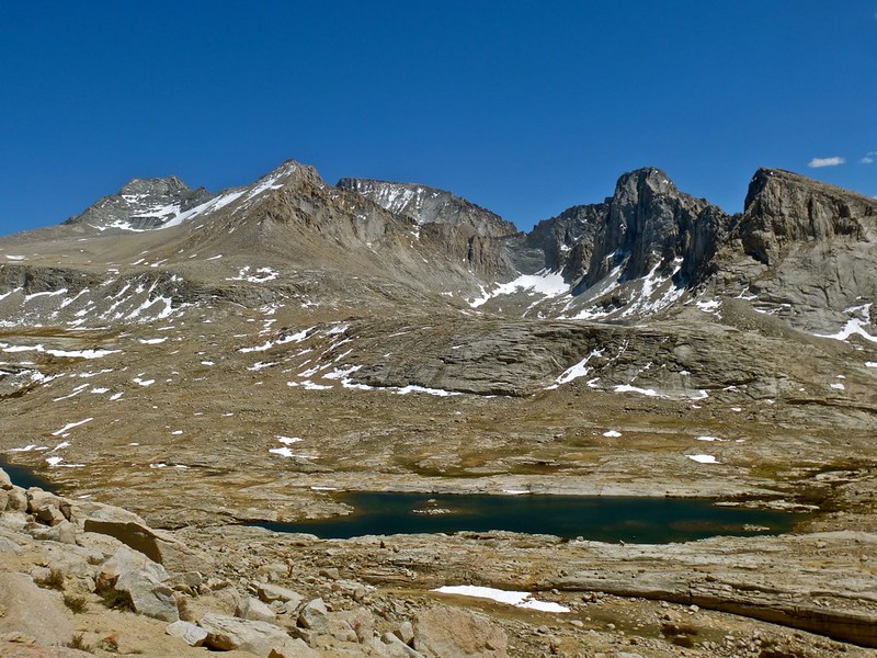
Well, somewhere along the way, I realized I might be delayed on my exit time, so I took the JMT almost to Guitar Lake, and then headed up to Arctic Lake. Looking up at the ridge between Wales and Arctic lakes, I was really glad I'd decided to skip it. It was too-steep-to climb granite; descending would be impossible without rappelling. As for fish in Arctic Lake: zero, zilch, none! The lake appeared void of anything but green moss covering all the rocks under murky water. No sign of fish at all. I tried a few casts, but of course, nothing.

I then continued on up to the Whitney Russell pass (skipping the north slope of Whitney), making it down to Iceberg lake at 4:30. There I filled up zip lock bags with 3 quarts of water, and went up the Mountaineers Route to stay overnight in the summit hut. I need to finish my HST trip report with this info.

If you're wanting to visit Wallace Lake, I'd just plan on heading up the creek from the JMT, and returning via the same route. You could spend at least a day up there -- Rogue Photonic posted a video sometime back catching voracious (but not huge) trout there.

If you went on up to Mt Russell, it is tough route -- finding the right descent might be tricky if you hadn't climbed it. I believe it is more technical than the Whitney MR. Doing all that with a full JMT backpack would be difficult.

Heres a Gmap4 map of the area: Arctic Lake

Re: Tulainyo Lake to Arctic Lake
DylanK #34948 01/19/14 01:11 PM
Joined: Sep 2009
Posts: 8,505
Likes: 103
S
Offline
S
Joined: Sep 2009
Posts: 8,505
Likes: 103
> is it possible to cross the west ridge of Mt. Russell and drop down to Arctic Lake

Shoot, I was so focused on the "drop down to Arctic Lake" part, I missed the Mt Russell part. Actually, one of the main routes up Mt Russell is the south slope, just west of the Whitney-Russell crest. So if you descended that, it would be quite easy to then head down to Arctic Lake. That Mt. R slope is a major talus slope. The west ridge looks way too steep, but that south slope will work, although tougher with a backpack. Make sure you study the climbing guide books to make sure you find the correct descent route (near the summit).

Re: Tulainyo Lake to Arctic Lake
Steve C #34951 01/19/14 03:00 PM
Joined: Nov 2009
Posts: 582
Offline
Joined: Nov 2009
Posts: 582
Only there's no "just" up Russell from that side. The north face, from the plateau above Wales Lake, is at least Class 3, moving into 4-5 along climber's right. The moves down the initial south face involves a bit of a chimney, which could be quite awkward while wearing a pack.

North face of Russell (from last June):


The back end of Wales Lake also didn't look entirely promising, either (from left: Rusell, Morgenson, Whitney, Hale):


At the easiest, you'll head up to Russell-Carillon Col, then up the east ridge of Russell, and down the south face to get to Arctic. I think you'll simply find the travel through the Wallace Creek drainage to be far more lovely, starting in the forest at the junction, following the gorge, walking the slabs and meadows above treeline, then exploring the high lakes. The scramble up to R-C Col is easy, even with a large pack, and the descent to Clyde Meadows is a blast in the scree.

A fabulous drainage, away from the crowds. Just make sure you get your Whitney Zone exit permit in advance.

Best,
L


Facebook

Flickr Pics

Think outside the Zone.
Re: Tulainyo Lake to Arctic Lake
DylanK #34954 01/20/14 12:27 AM
Joined: Dec 2009
Posts: 558
Offline
Joined: Dec 2009
Posts: 558
I personally would not like to climb up Russell - Carillion Pass / Col with a full pack and then to the summit of Russell. It can be done sure but I hope you have experience on all levels of class 3 with a pack on.

That's exactly the sort of crazy thing I normally plan and do but in this case I would not do it.

If it helps you at all I have a write up on Russell / Carillon Pass here

Last edited by RoguePhotonic; 01/20/14 12:28 AM.
Re: Tulainyo Lake to Arctic Lake
DylanK #34962 01/20/14 08:43 PM
Joined: Jan 2014
Posts: 18
J
Offline
J
Joined: Jan 2014
Posts: 18
There are two options. First is to follow user trails over Russell/Carillon Col to Upper Boy Scout Lk. then up to Iceberg Lk., over Whitney/Russell Col and down to Arctic Lk.
The second, more intrepid option, is to climb the north route on the West Pk of Russell (Pk 13,920/4245M) to the ridge and drop down the south side route to the Arctic Lk. drainage. The South side route has a short 20' class 4 section. Both routes are detailed in Secor's third edition to The High Sierra; Peaks-Passes-Trails.
Either would be an interesting way to finish your trip.
Happy trails.


Link Copied to Clipboard
Powered by UBB.threads™ PHP Forum Software 7.7.4
(Release build 20200307)
Responsive Width:

PHP: 7.4.33 Page Time: 0.042s Queries: 26 (0.037s) Memory: 0.5983 MB (Peak: 0.6673 MB) Data Comp: Off Server Time: 2024-03-28 14:39:15 UTC
Valid HTML 5 and Valid CSS