|
0 members (),
217
guests, and
326
robots. |
|
Key:
Admin,
Global Mod,
Mod
|
|
 Cirque Peak via Cottonwood Pass, May 17 & 18
|
Joined: Aug 2012
Posts: 671
|
OP

Joined: Aug 2012
Posts: 671 |
yet another idea for my mid-May trip (hoping to spend some time above 12k)... Just looking for opinions on whether or not this is a realistic/safe idea or not. I ran across some info involving a x-country route from the PCT to Cirque. Cottonwood Pass is the safest route when snow is clogging the other passes. Going over Cottonwood will allow you to summit Cirque Peak before doing Langley. Just exit the PCT when you see Cirque and head straight for it. When you leave Cirque stay as close to the edge as you feel safe till your reach the New Army Pass area then head for Langley I mapped out a possible route. Is this something that could safely be done with micros and trekking poles this early in the year? I realize that no one knows what the weather is going to be between now and then, but what is the likelihood of us NOT summiting due to snow/ice? Here's the route that I mapped out: Cottonwood Pass Trip, May 2014.
|
|
|
Re: Cirque Peak via Cottonwood Pass, May 17 & 18
|
Joined: Sep 2009
Posts: 1,253
|
|
Joined: Sep 2009
Posts: 1,253 |
Figuring this mid-May is the equal of early June after the biggest winters on record, you should be able to cross the pass with little to no problems. If there is a block, go back down trail and take the backdoor...consult your map. This back door is easy to see, if you look for it.
There might be some soft snow going up from Chicken Spring Lake until it tops out, nothing that need more than a pair of gaiters and poles.
You need to be able to recognize the cut up to Cirque. Before you get to point on your right you will see nothing forward. When it opens up, angle for the high point.
I have done this twice in early June. I took the most direct route possible, which took me through some large snow field, once with very little postholing, the other with a lot. These field can be by passed.
The summit requires you to pick your way through the boulders. Nothing really technical, you just need an eye for picking the easiest and safest route.
|
|
|
Re: Cirque Peak via Cottonwood Pass, May 17 & 18
|
Joined: Aug 2012
Posts: 671
|
|
OP
Joined: Aug 2012
Posts: 671 |
Thanks wbtravis. I really appreciate the input.
I was looking at Recreation.gov for Cottonwood Pass permits. It says 'W,' which I believe means that permits can't be reserved and only walk-ins are available. Do you know if CWPass permits are limited this time of year? Is there anyway to get them ahead of time? I may be arriving in Lone Pine outside of the Ranger's Stations business hours.
|
|
|
Re: Cirque Peak via Cottonwood Pass, May 17 & 18
|
Joined: Sep 2009
Posts: 8,538 Likes: 107
|
|
Joined: Sep 2009
Posts: 8,538 Likes: 107 |
There are plenty of Cottonwood pass permits available. I think the "W" indicates there is no quota at this time and all you do is walk in and request one. Later in the summer (Fri, June 27) they have reservable permits. But of the reservable days, the first fully reserved date is July 24. And that is only the 60% reservable. 40% (16 permits) area held back and available for walk-in requests starting the day before the entry date.
|
|
|
Re: Cirque Peak via Cottonwood Pass, May 17 & 18
|
Joined: Aug 2012
Posts: 671
|
|
OP
Joined: Aug 2012
Posts: 671 |
Thanks Steve.
Do you know if there is a way to get the permits ahead of time? There's a good chance that I will be arriving late Friday night or early Saturday, outside of the Rangers Station's operating hours.
I would call the Ranger Station, but based on how glitchy the recreation.gov website is today, I bet they're busy!
|
|
|
Re: Cirque Peak via Cottonwood Pass, May 17 & 18
|
Joined: Sep 2009
Posts: 8,538 Likes: 107
|
|
Joined: Sep 2009
Posts: 8,538 Likes: 107 |
In the past, they have tried to accommodate people with plans like yours. Whitney permits have been made available in the night box kiosk by the road in front of the Visitor Center. If you have a reservation already, and for other permits, if they are available, I think they will accommodate.
First thing to do is call the Wilderness Permit office and discuss the possibility. They're the ones who would know.
760-873-2843
|
|
|
Re: Cirque Peak via Cottonwood Pass, May 17 & 18
|
Joined: Sep 2009
Posts: 8,538 Likes: 107
|
|
Joined: Sep 2009
Posts: 8,538 Likes: 107 |
63: I found this picture from Davey McCoy on that social media site, posted yesterday. It is from their recent New Army Pass climb to Langley: Not sure whether they used crampons, but they had ice axes. I think from the picture, though that crampons would help here. This is a view looking toward the top of New Army Pass: 
|
|
|
Re: Cirque Peak via Cottonwood Pass, May 17 & 18
|
Joined: Sep 2009
Posts: 1,261
|
|
Joined: Sep 2009
Posts: 1,261 |
Is that a cornice I see curling up above?
The body betrays and the weather conspires, hopefully, not on the same day. 
|
|
|
Re: Cirque Peak via Cottonwood Pass, May 17 & 18
|
Joined: Aug 2012
Posts: 671
|
|
OP
Joined: Aug 2012
Posts: 671 |
Thanks Steve. I posted to a thread on the other Whitney forum to ask for details about their hike.
|
|
|
Re: Cirque Peak via Cottonwood Pass, May 17 & 18
|
Joined: Sep 2009
Posts: 1,253
|
|
Joined: Sep 2009
Posts: 1,253 |
I would not want to pass that without tools. It ain't the up that gets ya...
|
|
|
Re: Cirque Peak via Cottonwood Pass, May 17 & 18
|
Joined: Jul 2012
Posts: 219
|
|
Joined: Jul 2012
Posts: 219 |
I was up to Cottonwood Pass yesterday. The trail is virtually snow free right up to the Pass. There are some patches here and there but nothing dramatic that needs traction.
However, today I was going to do Cirque Peak from Cottonwood Lakes-South Fork lakes trail. While the trail from Cottonwood Lakes is clear to the 3.3 mile trail junction, there is quite a lot of snow once you turn off on the branch off to South Fork lakes. I think you could get there fine in the morning because the snow is firm but if you're returning in the afternoon you will post hole pretty deep as some of the snow banks were 3-5ft easy. I did not turn right up to Cottonwood Lakes (to new army pass) but at least from what I saw there was no snow on the initial portion of that section near the junction.
I also saw several sets of bear tracks on both trails, including a big print at 11,000 feet just before Cottonwood Pass. So, assume that bears are active in the area.
|
|
|
Re: Cirque Peak via Cottonwood Pass, May 17 & 18
|
Joined: Aug 2012
Posts: 671
|
|
OP
Joined: Aug 2012
Posts: 671 |
I was up to Cottonwood Pass yesterday. The trail is virtually snow free right up to the Pass. There are some patches here and there but nothing dramatic that needs traction.
Thanks for the info nyker, that's very helpful and encouraging! Did you happen to hike towards Chicken Spring Lake from Cottonwood Pass? I wonder how much snow is on the trail there.
|
|
|
Re: Cirque Peak via Cottonwood Pass, May 17 & 18
|
Joined: Jul 2012
Posts: 219
|
|
Joined: Jul 2012
Posts: 219 |
I did actually! Long story...but, in short, there is very little snow to Chicken Spring Lake coming from Cottonwood Pass via the PCT. There are patches here and there and more at the lake itself, but nothing on the trail to the lake requiring snowshoes. I did see a lot of bear tracks though from 11,000ft on the Cottonwood Pass Trail along to the PCT. I have a few pics of them. SO make noise when you hike there...
I actually attempted Cirque Peak from Chicken Spring Lake on Saturday. Of course, I underestimated the distance, and I left too late knowing that I needed to drive back to LA for a flight that night...
Nonetheless, once I got to the Lake, I headed due west making an ascending traverse (ie following no route) towards what I *thought* was the summit of Cirque Peak. After getting over the hill to the west/southwest of the lake and on top of the ridge, I kept climbing up to the west/NW, clear of the cornice that was on the peak and towards the top, only to realize there was another summit further to the NW 12.5k or so, then another small pile of rocks, then the peak which seemed to be Cirque Peak further out another 0.5 mile or so as the crow flies.
Realizing I needed to then downclimb to the saddle of sorts it was taking too much time and I figured I had to turn around given my early flight yesterday. But it was very doable to get Cirque peak from there if you don't mind some cross country travel. I will be back to do that again! Consequently, I think staying on the PCT another 1.5-2 miles would have precluded the need to go cross country so much and would have been more direct, but it was pretty fun going directly west from the lake in a truly stunning part of the mountains there.
|
|
|
Re: Cirque Peak via Cottonwood Pass, May 17 & 18
|
Joined: Aug 2012
Posts: 671
|
|
OP
Joined: Aug 2012
Posts: 671 |
Thanks again for the info! We plan to hike to Chicken Spring Lake and setup camp there. In the afternoon I'll hike the PCT northwest until I find a good spot to cut up the side of the mountain to the peak. I will mark the spot on my GPS as a waypoint. We are hoping to be on the peak for sunrise, although it's hard to estimate how much time we will need. I am guessing it will be about 3 miles from the lake to the peak and take us about 2 hrs. The last mile or so will be about a 30% grade: Cirque X-Country from PCTWhat part of NY are you from? I went to school in Saratoga Springs.
|
|
|
Re: Cirque Peak via Cottonwood Pass, May 17 & 18
|
Joined: Jul 2012
Posts: 219
|
|
Joined: Jul 2012
Posts: 219 |
The camping sites there look pretty nice and the meadow/basin you see from the top of the Pass when you start walking west on the PCT is such a nice view, a great place to plan to have lunch, but it was pretty windy. Have lunch behind that big rock (where you might also see some bear tracks if it hasn't rained).
On Sat, Chicken Spring lake was frozen fyi, and not much was flowing in that little effluent running down to the east.
Your mileage of ~3 mi sounds about right. I'd be interested to know where you will break off and turn for the peak. That southern slope that appeared to come off the trail seemed long, but not that steep.
The cross country route up due west from the lake was not a bad route and was very scenic, but a bit more cumbersome than the trail I imagine. Next time, perhaps I will do a loop - deadreckon up from the lake and down the trail on the way out.
I am a bit familiar with Saratoga...these days I am down state, though lived in the capital region for six yrs. Did you visit the Adirondacks when you were there?
|
|
|
Re: Cirque Peak via Cottonwood Pass, May 17 & 18
|
Joined: Aug 2012
Posts: 671
|
|
OP
Joined: Aug 2012
Posts: 671 |
I'd be interested to know where you will break off and turn for the peak. I will post a gpx file from the hike. Did you visit the Adirondacks when you were there?
Sadly, this was before I was into hiking. There's a good chance we'll be relocating to New England in the next year or so. If that happens, I'll be spending some time in the Adirondacks and White Mtns.
On Sat, Chicken Spring lake was frozen fyi, and not much was flowing in that little effluent running down to the east.
That's good to know. Thanks!
|
|
|
Re: Cirque Peak via Cottonwood Pass, May 17 & 18
|
Joined: Sep 2009
Posts: 1,253
|
|
Joined: Sep 2009
Posts: 1,253 |
Cirque X-Country from PCT
We cut up further back...before the ridge...according to our GPS track.
As soon as you see the peak, cut towards.
|
|
|
Re: Cirque Peak via Cottonwood Pass, May 17 & 18
|
Joined: Aug 2012
Posts: 671
|
|
OP
Joined: Aug 2012
Posts: 671 |
Cirque X-Country from PCT
We cut up further back...before the ridge...according to our GPS track.
As soon as you see the peak, cut towards. Thanks! Playing around with Google Earth, it looks like Cirque first comes into view about a 1/2 mile before the spot I've marked on the map. This link is centered on the spot: Gmap4Here's the view: 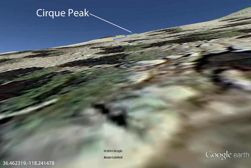 Does that seem right?
Last edited by 63ChevyII.com; 05/06/14 03:06 PM.
|
|
|
Re: Cirque Peak via Cottonwood Pass, May 17 & 18
|
Joined: Sep 2009
Posts: 1,253
|
|
Joined: Sep 2009
Posts: 1,253 |
It's real obvious because all you see on the right is boulders until it opens up.
You will know when to climb, believe me.
|
|
|
|
|