|
0 members (),
116
guests, and
6
robots. |
|
Key:
Admin,
Global Mod,
Mod
|
|
 Satellite Photos: Rough Fire
|
Joined: Aug 2011
Posts: 584 Likes: 13
|
OP

Joined: Aug 2011
Posts: 584 Likes: 13 |
I thought that these were pretty cool images. 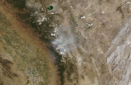 Original link here. Also I think you can descry the WZ! 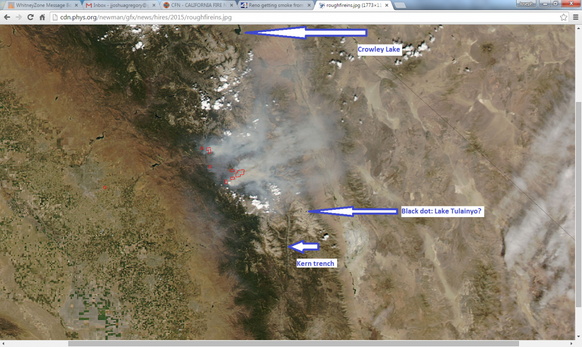
@jjoshuagregory (Instagram) for mainly landscape and mountain pics
|
|
|
Re: Satellite Photos: Rough Fire
|
Joined: Sep 2009
Posts: 8,538 Likes: 107
|
|
Joined: Sep 2009
Posts: 8,538 Likes: 107 |
I think you identified it. I don't know if you tried, but if you click on the map image on the link you gave, it brings up a very-much enlarged version. (link) ...edit: oh, from the pics in the picture gallery, I see you did. That fire area is huge! The Williamson webcam shows a really dirty brown cloud coming over the Sierra this afternoon.
Last edited by Steve C; 09/02/15 05:45 PM.
|
|
|
Re: Satellite Photos: Rough Fire
|
Joined: Aug 2011
Posts: 584 Likes: 13
|
|
OP
Joined: Aug 2011
Posts: 584 Likes: 13 |
I think you identified it. Yass! Today it looks as if a windshift pushed the smoke further south. Good news for the Labor Day crowd, such as meself. Here's hoping I can snag a couple FCFS sites tonight!
@jjoshuagregory (Instagram) for mainly landscape and mountain pics
|
|
|
Re: Satellite Photos: Rough Fire
|
Joined: Aug 2011
Posts: 584 Likes: 13
|
|
OP
Joined: Aug 2011
Posts: 584 Likes: 13 |
Also, I can pick out Lake Tulainyo and Wallace lakes, but what is the lake to the southwest of the WZ (the visible black dot) is it Crabtree?
@jjoshuagregory (Instagram) for mainly landscape and mountain pics
|
|
|
Re: Satellite Photos: Rough Fire
|
Joined: Sep 2009
Posts: 8,538 Likes: 107
|
|
Joined: Sep 2009
Posts: 8,538 Likes: 107 |
Yes, it's the middle Crabtree Lake. Here's what I use do identify and compare maps, best online mapping site ever: Gmap4, middle Crabtree Lk. (you can remove the "&symbol=pg" from the URL to remove the green pointer) Play with that map, and use the menu in the upper right corner. I use "t4 CalTopo hires" mostly, and then switch between satellite and google terrain as well. Note that with satellite, you can zoom in at least 4 clicks more than with t4, so when you switch back to t4, it can zoom back to its highest res view. A note, though: I use Firefox, and it views the maps ok, until you start zooming and panning all over the place. After a while, it begins stalling. I found that the Google Chrome browser does not have that trouble.
Last edited by Steve C; 09/03/15 11:28 AM.
|
|
|
Re: Satellite Photos: Rough Fire
|
Joined: Sep 2010
Posts: 46
|
|
Joined: Sep 2010
Posts: 46 |
Thanks to Steve C for the kind words. I am the Gmap4 developer. Here is an online fire map I produced centered on the Rough fire: http://www.mappingsupport.com/p/gmap4.ph...land_fire_3.txtIf you click the basemap button (next to the "Menu" button) then you can turn on/off and restack various layers of data that are delivered to your screen straight from the GIS servers where the data is hosted. You can click the 'top' layer and a popup will display with all the attribute data the GIS server has for the thing you clicked. When the map opens the crosshatch (burned area and fire perimeter) is on 'top'. To see the map legends and get more tips for using the map, please click "About this map" in the upper left corner. Wanna know how to make your own custom map link for this fire map? Click "About this map". Joseph, the Gmap4 guy
|
|
|
Re: Satellite Photos: Rough Fire
|
Joined: Sep 2009
Posts: 8,538 Likes: 107
|
|
Joined: Sep 2009
Posts: 8,538 Likes: 107 |
I tried the map link Joseph provided, and it is (again) the BEST place to view the status of the fire. Here's a "T4 Topo" link to the map. It sure beats the InciWeb map for the fire.
|
|
|
Re: Satellite Photos: Rough Fire
|
Joined: Sep 2011
Posts: 1,158
|
|
Joined: Sep 2011
Posts: 1,158 |
Gmap4 is awesome. The beauty of GIS really shines for tracking fires and floods. What a powerful tool for emergency response management, as well as follow up work after the incident - like revegetation work on steep burned slopes to prevent erosion and mudslides. A picture tells 1,000 words and each data layer adds another 1,000 words of info. But really, overlaid on top of each other can be more like 1,000 x 1,000. The ole saying needs to be updated, a picture may tell a 1,000 words but GIS tells a million.
|
|
|
Re: Satellite Photos: Rough Fire
|
Joined: Aug 2011
Posts: 584 Likes: 13
|
|
OP
Joined: Aug 2011
Posts: 584 Likes: 13 |
@jjoshuagregory (Instagram) for mainly landscape and mountain pics
|
|
|
Re: Satellite Photos: Rough Fire
|
Joined: Sep 2009
Posts: 8,538 Likes: 107
|
|
Joined: Sep 2009
Posts: 8,538 Likes: 107 |
Oh my goodness! Cat Haven is a non-profit place in the foothills on the Hwy 180 that heads up to SeKi, and they have been told they should evacuate! They have a number of pens with exotic wild cats from around the world. It appears the fire is heading toward them! Here's the Rough Fire map link, but with the center cross-hairs on Cat Haven. Zoom out about 6 clicks to see where the fire is.
|
|
|
Re: Satellite Photos: Rough Fire
|
Joined: Aug 2011
Posts: 584 Likes: 13
|
|
OP
Joined: Aug 2011
Posts: 584 Likes: 13 |
Yikes, according to news reports and their Twitter feed the owners are working to safely transport the animals to the nearest zoo. Thank goodness. I read a book on the Esperanza Fire of 2006. In the book a Firefighter recounts defending a remote house with several dog kennels and a horse corral. Though they defended the structures, (and saved the animals) they had to leave them in the cages. He once released some horses to fend for themselves, the horses went crazy romping around the defensible space almost taking out a few firefighters. Unfortunately big cats would unquestionably be left in their spaces. Looking at the GMAP and the images of the facility they have little defensible space. It's a kitty-roasting tinderbox.
@jjoshuagregory (Instagram) for mainly landscape and mountain pics
|
|
|
Re: Satellite Photos: Rough Fire
|
Joined: Oct 2009
Posts: 2,251 Likes: 1
|
|
Joined: Oct 2009
Posts: 2,251 Likes: 1 |
I've been following progress, as of 20 minutes ago they had all but 4 big cats crated up.
"Still working on crating our precious cats- big, hot ash falling around us. Big plumes of smoke just over our ridge. Making progress. Our staff, oh, you won't believe the wonder, our vet, our friends, so much to be thankful for."
If I was close I would volunteer to take the Clouded Leopard home.
Verum audaces non gerunt indusia alba. - Ipsi dixit MCMLXXII
|
|
|
Re: Satellite Photos: Rough Fire
|
Joined: Sep 2009
Posts: 8,538 Likes: 107
|
|
Joined: Sep 2009
Posts: 8,538 Likes: 107 |
It has been quite smoky on the west side the past two days. I could smell smoke in the air this morning. Here's a MODIS satellite picture taken Sept 7: (source)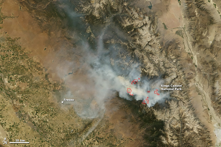 Here is a link to a current smoke map: smoke viewer
|
|
|
Re: Satellite Photos: Rough Fire
|
Joined: Sep 2009
Posts: 8,538 Likes: 107
|
|
Joined: Sep 2009
Posts: 8,538 Likes: 107 |
I've been following progress, as of 20 minutes ago they had all but 4 big cats crated up.
"Still working on crating our precious cats- big, hot ash falling around us. Big plumes of smoke just over our ridge. Making progress. Our staff, oh, you won't believe the wonder, our vet, our friends, so much to be thankful for."
If I was close I would volunteer to take the Clouded Leopard home. Here's how they got it done: Moving a Big Cat ( from pics from FB) 
|
|
|
Re: Satellite Photos: Rough Fire
|
Joined: Sep 2011
Posts: 1,158
|
|
Joined: Sep 2011
Posts: 1,158 |
Last edited by Steve C; 09/30/15 09:14 PM. Reason: Update
|
|
|
|
|


