|
0 members (),
413
guests, and
10
robots. |
|
Key:
Admin,
Global Mod,
Mod
|
|
 Aborted Trip Report MMWT 6/24 - 6/25
|
Joined: Aug 2010
Posts: 511
|
OP

Joined: Aug 2010
Posts: 511 |
I really didn't know for sure that I was going to do this hike until thursday 6/23. My wife and I were negotiating our schedules and it was pretty clear that this was the last weekend I would be able to go until August or September. So, I got the go ahead and did some shopping at 11pm thursday night and sparked up the BBQ at midnight to cook my chicken breasts for my famous (in my mind) backpacker's chicken soup/stew. Made it to the MW visitor's center having called ahead to find out that there were "plenty" of permits available. Got my permit, swung by the Subway for a sandwich and then on up to the portal. I stopped by the portal store to get directions to the old trail. I went back to the loop road behind the fishing pond and found the "big" rock and started up what I thought was the trail. I saw about 15 rocks lined up like they were lining a trail, so I felt confident I was on the right track. This was the last bit of confidence that I had. There was a trail of sorts. And there had been a lot of dead wood clearing in the area so I thought, "must be the right place, why would they clear dead/fallen trees if there wasn't a trail here. It seemed odd that the trail....and I am positive that it was a trail at one time, had so many pine needles on it. It didn't seem like it got much use at all. And steep too. These weren't switchbacks so much as a trail that swung back and forth on a very steep ascent. But I figured, "well, these guys are much more experienced than I am so this is probably no big deal for them" (that applies to pretty much everybody when compared to me). This trail kept pushing me to the left (south). Mainly because there was this giant granite face that would be formidable to pretty much anyone. Finally, I see a notch in the granit face. But it is a climb, not a hike...no question about it. So it couldn't be the right place....so I went left toward lone pine creek. And I was following a pretty clear trail. I was also looking for boot tracks. And I thought I saw several and started following them. I'm pretty sure that I was in a fog at this point, because i looked a little closer and they were pretty clearly double hoove prints...DOH!! I knew I was on the wrong track again, but I wasn't worried. If worse came to worse, I could just go back to the portal and start again tomorrow (today). But I knew that if I kept going up that I would have to hit the trail eventually. No joy. This nice clear trail went up next to the cliff and then stopped...or turned into an undergrowth animal use trail.#$#%#$@#$@#....I had to turn back. I can't tell you how much I hate and avoid going back downhill on an uphill hike. I head back to the notch that I described earlier. I know it isn't part of the old trail, but I am certain that this big granite face is the granite slab that parallels the southside of the lower switchbacks. If I can just get up and over, I should find the trail. So I climb up the notch. I had to take my pack off and throw it up ahead of me as it was a tight space and climbing rocks with a 35lb pack just didn't seem too bright for someone of my skill level. I get through the notch....#%@#$@#$...yeah sure it's clear, but there's another rock face. I'm doomed. I can see the trail along the north side of the valley that leads to the north fork crossing. I am considerably higher than it, so I figure that I can cross country down and to the north and I will have to hit the trail. I don't like this idea, but..... Then I see some movement above me out of the corner of my eye...up on that second rock face....it was golden brown and pretty large. Not a bear...no way...it was mid-afternoon and it was the wrong color. Mountain lion?....nah, they'd never let me see them.....then I see it again...OMG! it's a hat!!! I can just barely see someone's head over the ledge. Elation! But, I had to get up there. I see another notch in the rocks....only about a foot wide and not deep, I start climbing up to the tree at the top....back into the same situation, I can't get over the ledge with my pack (it also was getting blocked by the branches. I take my pack off again and throw it up on the rock...then throw my hiking poles up on the rock and climb over the ledge using the branches of the tree for suppport. And 40' away is a switchback. And a guy is walking up toward me. I ask him the time....3:45. I tell an abbreviated version of my story to this point and he says "oh yeah, I just came up the old trail". I asked how far back...he said "oh 10 minutes or so". I wasn't even that much further up the trail...dammit. I was pretty beat up. I had several blood streaks going down my legs from cuts when I was climbing the rocks and frankly, it was just damn hard work. The rest of the hike was uneventful. I was having a few issues with my knee (ACL surgey a few years ago, but it never got totally right). So I took it very slowly and took a fair number of rest....or as I like to call them "moments of reflection". Once you get to the wet parts of the trail, the mosquitos are relentless. I had bug repellent on...and it worked...for the most part. I missed one spot right along the sock line on my leg. I have about 15 bites all bunched up. It actually looks really disgusting. Recommend long sleeves, long pants. Got to Lone Pine Lake. I wasn't sure that I was going to stay there just yet. the whole area is very wet with lots of rivulets heading down to the lake. I figured that I would head up to Outpost at my leisure after I ate some food. Well.....I found a very nice dry spot and there was absolutely nobody there, so i decided to spend the night there. I could still make trail camp pretty easily when I got up i the morning. I got into the tent pretty shortly after eating. The mosquitos never let up. Got to sleep pretty easily...and then was woken up by something large checking out my camp. I made some noise and it went away. But I never checked to see if it was a bear. But by now, I was wide awake and stayed that way until about 5am. When I woke up, I was still pretty sore, but I hadn't decided to turn back yet. There is a lot of snow on the north facing slopes in the LPL area. I decided to break out the ice axe and practice glissading and self arrest. I walked up 5 times and had fun doing the exercises. (you can see my boot tracks on the left side of the snow slope). After that, i figured that I really had accomplished what I came for and since I was still hurting, I should just head down the hill. I did find the old trail on the way down. Two guys who were hiking in front of me went down just past the second sign. I followed. They were a little bit high and had to go about 20' left to catch the actual switchbacks. I have photos of most everything. Including the big rock that you should pay no attention to if you are looking for the old trail and the massive granite outcropping that you should..... now...I need to take a shower!
|
|
|
Re: Aborted Trip Report MMWT 6/24 - 6/25
|
Joined: Aug 2010
Posts: 511
|
|
OP
Joined: Aug 2010
Posts: 511 |
Other notes:
Snow: Like I said, there are ample amounts of snow in the LPL area. I did my glissading/self arrest practice around 9:30am. The sun was definitely on the slopes. But the snow was hard, not super slushy. I didn't have crampons, but I wasn't worried, it was my intent to slip on the snow...and I did. To get to the high point, I really had to kick in steps. Fortunately, someone had been there before and had made some steps for a decent portion of the ascent. When I looked back up the hill, I could barely make out my glissade track. I just wasn't moving that much snow.
Lone Pine Lake: It is beautiful and very full. I have always been able to walk along the north side of the lake to get to the ridge to get cell reception...no joy. You'll have to go up on the ridge above the lake for that. The south side of the lake has a mini glacier overhanging the lake....some people have made a trail across it. I think I'll avoid that one. There aren't a lot of dry campsites at the lake. The runoff has made for a great water source, but a really lousy camping area (except of the little spot that was perfect for my one-man tent).
Glissading: Was a blast
Self-Arrest: Was not that big of a deal. However, I noticed that I was letting my arm extend out so that my body weight was not over the head. This became significant on a steeper incline when I wasn't really stopping. When I pulled my body up over the head, I stopped very quickly.
SPOT: I think that the SPOT may have been as lost as me at times. There are tracks on there that don't make a lot of sense and where I am pretty sure I never ventured.
I finally had a ranger ask for my permit. A guy named Chris who was heading to outpost to prep the area for a volunteer group coming up to do trail maintenance next week.
Last edited by tdtz; 06/25/11 05:56 PM.
|
|
|
Re: Aborted Trip Report MMWT 6/24 - 6/25
|
Joined: Sep 2009
Posts: 8,538 Likes: 107
|
|
Joined: Sep 2009
Posts: 8,538 Likes: 107 |
Thanks for the report, Tom. Too bad you got so beaten up on account of the "old trail mis-adventure."
Looking forward to the pictures.
|
|
|
Re: Aborted Trip Report MMWT 6/24 - 6/25
|
Joined: Nov 2009
Posts: 595
|
|
Joined: Nov 2009
Posts: 595 |
A recommendation on the "new trail/old trail" - don't attempt to find the old trail in the dark on your first trip. By "old trail" I mean the first mile near the Portal as in reality there are other sections of "old trail" between the Portal and the summit. While it's right behind the very large rock at the "top" of the paved road (immediately above the fishing pond) it's still a little tricky to find. Or at least that's my experience, and I've done it at least a dozen times.
It's questionable whether it saves that much time, either. Maybe 5 minutes? 10?
Keep your eye on the ball. What's your goal, anyway? Make the summit? Or make the summit while saving 30 minutes (maybe?)?
My advice is- look for shortcuts after you've been on the MT maybe 25 or so times. Fine tune things then. Don't get sucked into all the "secret" paths or it will distract you from your goal.
|
|
|
Re: Aborted Trip Report MMWT 6/24 - 6/25
|
Joined: Aug 2010
Posts: 511
|
|
OP
Joined: Aug 2010
Posts: 511 |
Kevin,
fortunately my plans specifically didn't call for a trip to the summit.
Without crampons i know that I would never make it up the chute.
This was my 5th time on the mountain, so I have some familiarity with where the main trail actually is. And part of my stated goal for this trip was to use the old trail (and avoid the north fork crossing, though that could be fun in its own way).
In the future when going up with a full pack, I plan to use the standard new boring and much less steep trail. One thing that it does is to let your legs loosen up instead of immediately going into full exertion mode. But coming down, I probably won't ever use the new trail beyond the old trail cut off.
Anybody who knows me and my hiking style knows that I am not looking to shave time off of my hike times. I am about as leisurely as you can get.
I suspect that this trip may end up being one of my favorites simply because it was such a misadventure. And I do have a sense of accomplishment in that I was able to get to the trail eventually by a very challenging route.
Last edited by tdtz; 06/26/11 07:56 AM.
|
|
|
Re: Aborted Trip Report MMWT 6/24 - 6/25
|
Joined: Nov 2009
Posts: 595
|
|
Joined: Nov 2009
Posts: 595 |
tdtz -
Glad to hear that mis-adventure didn't wreck your trip, but I mostly made that post because many use the TR's to plan their own trip. Am glad you made the point about heavy packs/steepness of the trail, as the old trail is steep, and the footing a bit rough/loose. Nearly all my trips up Whitney are dayhikes, so I'm traveling a bit lighter.
Another questionable practice I'd add to the list of things not to do include doing a big hike at elevation a day or two before THE hike, up to and including White Mountain. Unless someone's got alot of time to spend in the mountains (and very few do unless you live here and are retired/semi-retired) it's crazy to do a big "acclimatization" hike unless they have 4 or 5 rest days before Whitney. There are exceptions of course, if people are extremely fit, but sometimes even elite marathon runners without altitude experience overdo and crash before the summit.
Anyway, glad your recent trip will be added to the 'memorable' trip category.
|
|
|
Re: Aborted Trip Report MMWT 6/24 - 6/25
|
Joined: Aug 2010
Posts: 511
|
|
OP
Joined: Aug 2010
Posts: 511 |
and speaking of heavy packs....
I always pack more food than I need. I am hypoglycemic and if my blood sugar drops too low I first go through a really obnoxious stage, but after that I become downright irrational.
I bring this up because when I am packing food I go through this mental pre-fear that I will get into a low blood sugar situation and not have enough food.
I cut down weight by eliminating a lot of extra clothing. but I probably had at least a pound of food, if not a pound and a half, that I simply didn't need. Somehow I am going to need to balance my hypoglycemic fear with the reality of how much food I will need. (I've never had a problem with eating at altitude).
And I certainly wouldn't use this particular trip report as a guide for planning trips. Hopefully though, through the honesty of the report, I have conveyed the boneheadedness in the way I went about identifying the start of the old trail.....and the consequences of that boneheadedness.
|
|
|
Re: Aborted Trip Report MMWT 6/24 - 6/25
|
Joined: Oct 2010
Posts: 453 Likes: 1
|
|
Joined: Oct 2010
Posts: 453 Likes: 1 |
Thanks for the report and pictures Tom. I wanted to use that old trail last time but couldn't even find it in the light. I ended up hiking up the waterfall and around that area for my acclimatization hike before Whitney. Thanks for taking one for the team.  Your report also reminds me of how awesome the mountaineers were back in the days. No trail, no Internet for directions, no people along the way for help or guidance...how awesome those guys and gals were!
|
|
|
Re: Aborted Trip Report MMWT 6/24 - 6/25
|
Joined: Nov 2009
Posts: 1,256 Likes: 2
|
|
Joined: Nov 2009
Posts: 1,256 Likes: 2 |
Tom, enjoyed the TR. Well, not "enjoyed", but you know what I mean. That which don't kill you makes you stronger (and wiser) - right? Sorry you had such a crappy experience from the outset, but if you hike long enough it's inevitable. We've all been through something similar. I completely missed the peak I was shooting for once, in perfect weather and with a topo map - talk about feeling like a knucklehead! Notch your belt with the experience and look forward to the many times you'll get to entertain people with that story around a campfire with some brews. I especially appreciate the fact you were so forthcoming with the story - it should help get the attention of others considering the same thing. This trail has not been maintained in many years, so it's a use trail. The thing about use trails is that they can be hard to follow going up, and generally have a spiderweb of other branching use trails attached. When you're descending a use trail, it's easy to see where you need to go (and not go), but it can sometimes be a mystery on the ascent, especially the first time. I definitely would not want to try this one the first time in the dark. And yeah, this one is steep. My affinity for it comes from the fact that it bypasses the North Fork water crossing. I generally don't have issues with rock-hop water crossings, but when the NF is raging with snowmelt and the hops are inundated, I'm very conscious of that cascading drop-off just a few feet away from the rocks. This coming trip in July it's really my wife and daughter carrying heavy packs for the first time that concerns me on this crossing. Besides, while I've descended the Old Trail, I've never gone up it. My wife, however, has been up and down it three times, so I'll follow her . . .  Thanks again for the TR. Aug/Sep should be much better!
|
|
|
Re: Aborted Trip Report MMWT 6/24 - 6/25
|
Joined: Aug 2010
Posts: 511
|
|
OP
Joined: Aug 2010
Posts: 511 |
Hey Atari,
now that I know where the trail starts, it seems so obvious. But clearly it isn't.
I've added some notes to the photos.
It's funny, now that I know this new path up, i'd be curious to see if it is faster to go up the old trail or my new more direct route. There's not a chance in hell that I would use my route at night.
Last edited by tdtz; 06/26/11 02:50 PM.
|
|
|
Re: Aborted Trip Report MMWT 6/24 - 6/25
|
Joined: Aug 2010
Posts: 511
|
|
OP
Joined: Aug 2010
Posts: 511 |
I've been on the MMWT in five different months now; June, July, August, September and November.
September is my favorite month. A bit cooler and I didn't see any skeeters.
With the north fork crossing, I'd be a bit apprehensive with a youngin. So i can see how the old trail would be of interest.
The old trail is actually in pretty good condition
|
|
|
Re: Aborted Trip Report MMWT 6/24 - 6/25
|
Joined: Nov 2009
Posts: 567
|
|
Joined: Nov 2009
Posts: 567 |
Tom....You are my long lost brother. I mean who else could get in a situation like that.....well, except me. If you remember my Baldy trip last year UP the Bowl in Summer, where I actually admitted how I thought I was going to die!!! So, really, I love your honesty, loved your SPOT, laughed like hell.
You are safe and hopefully clean. If you remember my motto: "You didn't hike if you didn't Bleed". (Bee doesn't like that motto..)
Hope to hike with you sometime. I did Icehouse with wazzu today. I asked the question about this board, Where else can you meet other people from all over the WORLD, and get together and hike a mountain?. So far for me, Gary from Atlanta, Barbara from Orange County, Bullet777 from Australia. Love this board, love the people and feel you guys are all friends. Tom, you are the best. THANK YOU so much for sharing your adventure(s).
 "Turtles, Frogs & other Environmental Sculpture" www.quillansculpturegallery.comtwitter: @josephquillan If less is more, imagine how much more, more is -Frasier
|
|
|
Re: Aborted Trip Report MMWT 6/24 - 6/25
|
Joined: Aug 2010
Posts: 511
|
|
OP
Joined: Aug 2010
Posts: 511 |
Joe,
I love that motto!
I imagine that anyone watching the SPOT had to be thinking "what the hell is he doing?"
I definitely want to get some hiking in with you and Gary and Bee and Lynn and Steve and.......
We will get together this summer sometime.
Tom
|
|
|
Re: Aborted Trip Report MMWT 6/24 - 6/25
|
Joined: Aug 2010
Posts: 511
|
|
OP
Joined: Aug 2010
Posts: 511 |
tdtz trail vs Old trail google earth style. 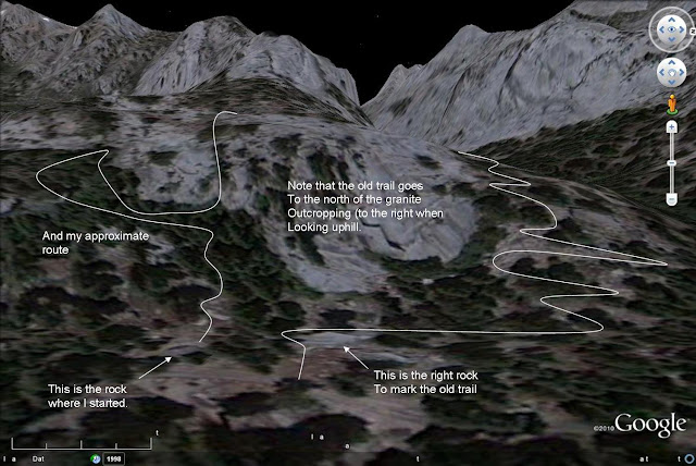
Last edited by tdtz; 06/26/11 06:58 PM.
|
|
|
Re: Aborted Trip Report MMWT 6/24 - 6/25
|
Joined: Sep 2009
Posts: 1,261
|
|
Joined: Sep 2009
Posts: 1,261 |
Google Earth is just the best; we used it to scope out potential kayak routes when there were complicated sloughs/deltas to navigate (great for aborting trips in the comfort of the home)
In reading your report, I can see how spoiled I have been in my intro to the Whitney Zone, as I have had the extreme luxury of following along with the likes of Doug, Sr., Bob R., Laura, & Steve C.
Based on my own solo extra-navigational "wanderings", I am sure that I would have a similar tale to tell.
The body betrays and the weather conspires, hopefully, not on the same day. 
|
|
|
Re: Aborted Trip Report MMWT 6/24 - 6/25
|
Joined: Aug 2010
Posts: 511
|
|
OP
Joined: Aug 2010
Posts: 511 |
Hi Bee, I love google earth. I actually use it in my professional life every day. Now this could be a guy thing...or just a Tom thing...not sure. I did ask for directions, but I don't really want to be guided on something like this. It's probably all based in ego. The first part being "I don't need to ask for help, I can do this on my own". The second part being that I hate it when people have to wait for me. I am definitely the turtle. I can go for very long distances and I can endure a lot of pain, but I'm going to do it at my pace. You do have quite the Whitney lumenaries on your list of hiking partners  Tom
|
|
|
Re: Aborted Trip Report MMWT 6/24 - 6/25
|
|
Burchey
Unregistered
|
|
Burchey
Unregistered
|
|
|
|
Re: Aborted Trip Report MMWT 6/24 - 6/25
|
Joined: Dec 2009
Posts: 225
|
|
Joined: Dec 2009
Posts: 225 |
and speaking of heavy packs....
I always pack more food than I need. I am hypoglycemic and if my blood sugar drops too low I first go through a really obnoxious stage, but after that I become downright irrational.
I bring this up because when I am packing food I go through this mental pre-fear that I will get into a low blood sugar situation and not have enough food. TDTZ.... small foods with good impacts. My son was hypoglycemic when he was younger and he went through similar stages to let us know he was going into an "episode of buttheadedness" as we called them.. I don't know how it works for you.. but peanut butter snacks, beef jerky and cheese sticks... the high protein snacks are what the doctors advised us to use for my son. Small snacks, easily stored, no refrigeration... his teachers always kept a stash in her desk...
|
|
|
Re: Aborted Trip Report MMWT 6/24 - 6/25
|
Joined: Aug 2010
Posts: 511
|
|
OP
Joined: Aug 2010
Posts: 511 |
Well, it looks like my little notch shortcut that I inadvertently took in June is well known. Bob Rockwell and fellow SAR dood, Mike, swept it on their way down this morning after the flash flood. Bob R describes it thusly: "78 This short cut has a delicate notch" looking up 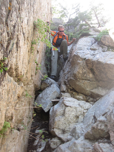 looking down 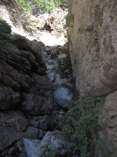 these photos are by Bob Rockwell. They can be found here. http://www.flickr.com/photos/rockwellb/sets/72157627194409465/with/5992608416/
|
|
|
|
|