|
0 members (),
404
guests, and
464
robots. |
|
Key:
Admin,
Global Mod,
Mod
|
|
 Re: Mt. Langley or White Mountain, May 17/18?
|
Joined: Sep 2009
Posts: 8,538 Likes: 107
|

Joined: Sep 2009
Posts: 8,538 Likes: 107 |
If you wanted to extend your hike you might want to consider heading up to
Cottonwood lake #6. This is actually another route to Langley, with a steep
chute to climb to the west of the lake. Hi John, is there a trail to lake #6, or a way you prefer to go? 63: It is wide-open almost moonscape-like there. You just pick a straight line and walk. Here is a link to the gmap4 map of the area, set on "t4 Topo High" (shows the best topo map). Switch the view to "s - Aerial Google Satellite" (in the upper right corner of the map), zoom in and move around. You can see how sparse the trees are. Here's So.BayMark's post climbing that chute: Shortcut to Langley 9-14-13If the snow is soft enough in the chute, that would make a fun climb to the Langley summit. Definitely need crampons and ice axe for it.
|
|
|
Re: Mt. Langley or White Mountain, May 17/18?
|
Joined: Apr 2012
Posts: 579 Likes: 3
|
|
Joined: Apr 2012
Posts: 579 Likes: 3 |
Hi 63, As Steve mentions it is really wide open in that area (at least in the summer, without snow). I have not actually been to Lake 6, but based on where I "think" you will be camping I suggest the route shown here: http://www.mappingsupport.com/p/gmap4.ph.../home/Lake6.gpxThis route takes you by the stream between Lake 4 and Lake 3 on a well established trail. You can turn right sooner if you are not going to camp at the north end of Lake 3 and cut some distance. Just stay left of Muir Lake, and "straight line" to Lake 6. Take lots of pictures:-) Really a beautiful place.
|
|
|
Re: Mt. Langley or White Mountain, May 17/18?
|
Joined: Aug 2012
Posts: 671
|
|
OP
Joined: Aug 2012
Posts: 671 |
If the snow is soft enough in the chute, that would make a fun climb to the Langley summit. Definitely need crampons and ice axe for it.
Dumb question/comment time.... That's probably not a slope you want to be on with an ice ax and crampons if you're a newb, correct? How do the slopes on NA, OA, and CL6 compare, assuming they're all covered with snow?
|
|
|
Re: Mt. Langley or White Mountain, May 17/18?
|
Joined: Oct 2010
Posts: 453 Likes: 1
|
|
Joined: Oct 2010
Posts: 453 Likes: 1 |
All are very steep, especially OA, and especially depending on where you exit at the top. It's not a place you want to learn how to self arrest.
From memory, the slope angle on OA is much steeper than the one leading from Trail Camp to Trail Crest on Whitney. If you cannot self arrest in time, you will get injured very badly at a minimum.
|
|
|
Re: Mt. Langley or White Mountain, May 17/18?
|
Joined: Aug 2012
Posts: 671
|
|
OP
Joined: Aug 2012
Posts: 671 |
All are very steep, especially OA, and especially depending on where you exit at the top. It's not a place you want to learn how to self arrest. That's what I figured! Thanks for the confirmation.
|
|
|
Re: Mt. Langley or White Mountain, May 17/18?
|
Joined: Aug 2012
Posts: 671
|
|
OP
Joined: Aug 2012
Posts: 671 |
I've wasted way too much time playing around with G4Map this morning! Cottonwood Lakes Map
|
|
|
Re: Mt. Langley or White Mountain, May 17/18?
|
Joined: Sep 2009
Posts: 8,538 Likes: 107
|
|
Joined: Sep 2009
Posts: 8,538 Likes: 107 |
Wow! Yes, you spent some time. Isn't Gmap4 the best?! Now wbtravis will tell you his alternate route to Cirque Lk. and you can put that on the map, too.
|
|
|
Re: Mt. Langley or White Mountain, May 17/18?
|
Joined: Aug 2012
Posts: 671
|
|
OP
Joined: Aug 2012
Posts: 671 |
If NA & OA aren't safe to hike without crampons/ice axe, should I assume that Cottonwood Pass and Trail Pass won't be safe either?
|
|
|
Re: Mt. Langley or White Mountain, May 17/18?
|
Joined: Sep 2009
Posts: 1,253
|
|
Joined: Sep 2009
Posts: 1,253 |
The "secret" route to the New Army is...
About 180' after you make the first creek crossing, on your left you will see small branches blocking a trail. Cross these branches. This will take up on a well established trail to South Fork Lakes. Go around the south shore of the lake, then it is cross country angling to the northwest. Eventually you will end back up on the NAP Trail just below Long Lake. This saves about a mile and eliminates the ups and downs and about 3 tons of horse droppings.
|
|
|
Re: Mt. Langley or White Mountain, May 17/18?
|
Joined: Sep 2009
Posts: 8,538 Likes: 107
|
|
Joined: Sep 2009
Posts: 8,538 Likes: 107 |
wbtravis: Thanks. I need to try that route someday.
63: It looks like you have added a Trail Peak loop to the map.
FYI: the topo maps showing the trail to Trail Pass is wrong. The dashed line goes straight up the canyon, but in reality the trail makes several nice switch backs between the spring and Trail Pass.
|
|
|
Re: Mt. Langley or White Mountain, May 17/18?
|
Joined: Aug 2012
Posts: 671
|
|
OP
Joined: Aug 2012
Posts: 671 |
the topo maps showing the trail to Trail Pass is wrong At your suggestion, I did Trail Peak a couple of years ago. I don't actually remember much of that hike though - a few hours later I had to rush home for the birth of my son, who decided to show up 2 weeks early  Do you think Cottonwood Pass could be (safely)hiked with micros & poles?
Last edited by 63ChevyII.com; 04/24/14 01:51 PM.
|
|
|
Re: Mt. Langley or White Mountain, May 17/18?
|
Joined: Oct 2009
Posts: 129
|
|
Joined: Oct 2009
Posts: 129 |
I will be climbing Langley and/or The Major General this weekend (May 3 - 4), probably by Navy Pass (you can look it up).
Will post pictures of the other passes and surroundings.
Paul, it would be good to see you. We'll park at the old trailhead to Cottonwood Lakes.
Bob
|
|
|
Re: Mt. Langley or White Mountain, May 17/18?
|
Joined: Aug 2012
Posts: 671
|
|
OP
Joined: Aug 2012
Posts: 671 |
Will post pictures of the other passes and surroundings.
Bob
Thanks, that'd be great if you could post some pics. I ran across a couple of gpx files of people hiking Langley via Cottonwood Pass. I also read that Cottonwood Pass is usually the first route to be clear of snow. I haven't seen much about this route, so I have a couple of questions: 1. It looks like the round trip mileage is about 29 miles. Is this correct? 2. If someone were doing this trip over two days, where would you suggest camping? 3. I assume I need the Cottonwood Pass permit, instead of the CWL Trail permit, correct? 4. If we hiked Cottonwood Pass, but then decided to not hike to Langley, what are some other peaks/things to see or visit in the area? I realize Cirque is there.
|
|
|
Re: Mt. Langley or White Mountain, May 17/18?
|
Joined: Sep 2009
Posts: 1,253
|
|
Joined: Sep 2009
Posts: 1,253 |
wbtravis: Thanks. I need to try that route someday. I've even used it to coming back from Army Pass. It does not eliminate the sand but it does eliminate the ups and downs and horse droppings. That CL/NAP trail is too heavily traveled for my tastes.
|
|
|
Re: Mt. Langley or White Mountain, May 17/18?
|
Joined: Oct 2009
Posts: 129
|
|
Joined: Oct 2009
Posts: 129 |
Thanks, that'd be great if you could post some pics.
Ask and ye shall receive: Pictures from the weekend I've climbed Langley et al from Cottonwood Pass a few times. But I struck directly up the ridge from the pass, heading north over Trailmaster, and camped either just beyond Trailmaster or at New Army Pass. Have to melt snow for water, of course. I have pictures posted on Flickr somewhere. For going up from the Cottonwood Lakes, camping in the trees at Third Lake is very nice. Fourth is more convenient to Army Pass, but less protected. Fifth is best for Navy Pass. View yesterday looking toward the Cottonwood Lakes and the Passes, from halfway up Woollyback (the obvious frozen lake is Muir Lake): 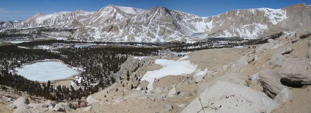
|
|
|
Re: Mt. Langley or White Mountain, May 17/18?
|
Joined: Apr 2012
Posts: 579 Likes: 3
|
|
Joined: Apr 2012
Posts: 579 Likes: 3 |
Thanks, that'd be great if you could post some pics.
Ask and ye shall receive: Pictures from the weekend Fifth is best for Navy Pass. Hi Bob, When the snow melts, is there any sort of a use trail on Navy Pass? How would you compare it to the chute west of Lake #6? Thanks, John
|
|
|
Re: Mt. Langley or White Mountain, May 17/18?
|
Joined: Aug 2012
Posts: 671
|
|
OP
Joined: Aug 2012
Posts: 671 |
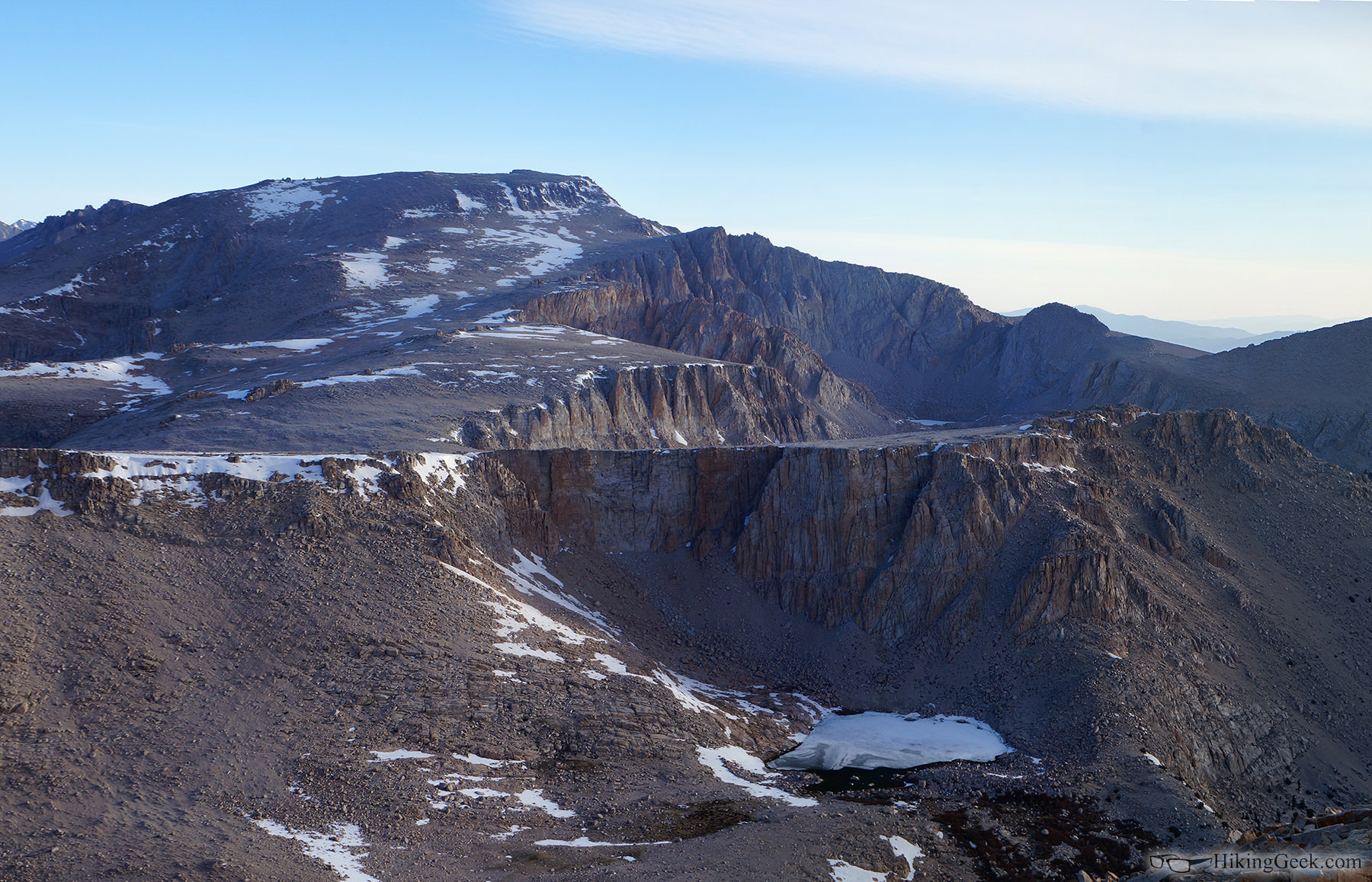
John, I believe this is CWL #6 (if not, please correct me), taken from Cirque Peak on 5/18: 
|
|
|
Re: Mt. Langley or White Mountain, May 17/18?
|
Joined: Sep 2009
Posts: 8,538 Likes: 107
|
|
Joined: Sep 2009
Posts: 8,538 Likes: 107 |
63, that's High Lake (Gmap4 map). NEW Army pass trail climbs the slope to the left of it. In fact, I can see two stretches of the trail on your full-size version of the picture. ...and it looks practically horizontal for a long way! (Old) Army Pass tops out just beyond the top of that vertical cliff in the picture center. Cottonwood Lake 6 is just on the other side of the plateau with the cliff. Edit: Looking at the map and then your picture, I think you tilted the camera just a little so the plateau looks horizontal. Actually, it climbs steadily to the right (east), as you can see from the contours on the map. And therefore, what appears to be a horizontal trail is actually ascending too. Here's a picture I took from Trail Peak of the same area. Slightly different angle and much farther away. 
Last edited by Steve C; 05/20/14 03:35 PM.
|
|
|
Re: Mt. Langley or White Mountain, May 17/18?
|
Joined: Aug 2012
Posts: 671
|
|
OP
Joined: Aug 2012
Posts: 671 |
63, that's High Lake ... cliff.
Thanks - that all makes sense. I can see you tilted the camera so the plateau looks horizontal... lol... this is a pano using 4 or 5 images. It's possible I tilted the camera or photoshop distorted it. I'll have too look at the originals to see.
|
|
|
Re: Mt. Langley or White Mountain, May 17/18?
|
Joined: Oct 2009
Posts: 129
|
|
Joined: Oct 2009
Posts: 129 |
John,
I believe this is CWL #6 (if not, please correct me) Looks like #6 to me.... 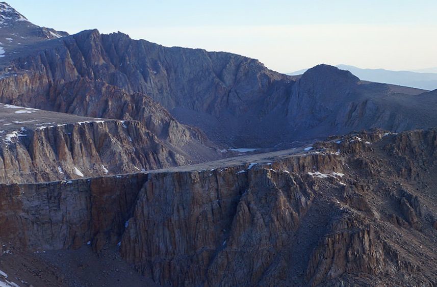
|
|
|
|
|